|
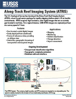
"Along-Track Reef Imaging System (ATRIS)" describes the U.S. Geological Survey's Along-Track Reef Imaging System, a boat-based sensor package for rapidly mapping shallow water benthic environments. ATRIS acquires high resolution, color digital images that are accurately geo-located in real-time.
Print version: fs-2006-3051.pdf (384 KB PDF)
Plain text version (open this file in any text editing program): fs-2006-3051.txt (2.6 KB TXT)
NOTE: You will need to have the free
Adobe Acrobat® Reader (v3.0 or higher) installed on your computer to view and print this publication. These two 11x17 inch pages can be scaled to 8.5x11 inch pages in the print dialog box.

|