Fact Sheet 2006-3120
Abstract
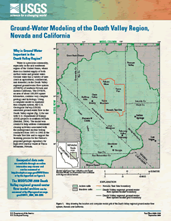
The Death Valley regional ground-water flow system (DVRFS) of southern Nevada and eastern California covers an area of about 100,000 square kilometers and contains very complex geology and hydrology. Using a computer model to represent the complex system, the U.S. Geological Survey simulated ground-water flow in the Death Valley region for use with U.S. Department of Energy projects in southern Nevada. The model was created to help address contaminant cleanup activities associated with the underground nuclear testing conducted from 1951 to 1992 at the Nevada Test Site and to support the licensing process for the proposed geologic repository for high-level nuclear waste at Yucca Mountain, Nevada. |
Version 1.0 Posted October 2006
|

![]() U.S. Department of the Interior | U.S. Geological Survey
U.S. Department of the Interior | U.S. Geological Survey
URL: http://pubsdata.usgs.gov/pubs/fs/2006/3120/index.html
Questions or Assistance: Contact USGS
Last modified: Thursday, 30-Apr-2026 13:42:44 EDT
