U.S. Geological Survey Fact Sheet 2006-3134
Published 2006
Online only
By Bradley W. Reed, Peter Larkins, and Gilpin R. Robinson, Jr.
| This Fact Sheet provides information on a digital data set that identifies orchard areas under cultivation between the 1920s and 1960s in Clarke and Frederick Counties, Virginia and Berkeley and Jefferson Counties, West Virginia. The apple orchards in these areas likely used arsenical pesticides during this time. The digital data set can be used in a geographic information system (GIS) to identify where elevated arsenic and lead concentrations may be present in soils. The digital data set, the associated metadata, and the related files are available on the World Wide Web at https://pubs.usgs.gov/of/2006/1330/shapefile/. |
This data set shows orchard locations in Clarke and Frederick Counties, Virginia and Berkeley and Jefferson Counties, West Virginia where arsenical pesticides have likely been used. The orchard locations were compiled from aerial photos and topographic maps for the time period of extensive use of arsenical pesticides between the 1920s and 1960s. An orchard's presence in this data set does not necessarily indicate the use of arsenical pesticides on that site or that elevated arsenic and metal concentrations are present. Arsenical pesticides may have been used on part, or none, of the land; furthermore, the land may have been remediated and may no longer contain elevated arsenic and metal concentrations in the soil.
The data set was created for use in an assessment of soil contamination related to past use of arsenical pesticides in orchards in the northern part of the Great Valley region, Virginia and West Virginia. Previous studies (Veneman and others, 1983; Jones and Hatch, 1937) have documented elevated concentrations of arsenic, lead, and sometimes copper occur in the soils of former apple orchards.
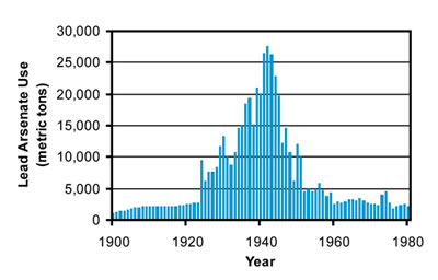
The application of arsenical pesticide was both extensive and widespread in agricultural applications from the 1920s to the late 1950s; however, agricultural use largely ceased by the early 1960s in the nation (Figure 1). During this time period, lead arsenate was the most extensively used arsenical pesticide (Peryea, 1998), particularly in apple orchards. Other metal-bearing pesticides, such as copper acetoarsenite (Paris Green), Bordeaux Blue (a mixture of copper sulfate and calcium hydroxide), and organic mercury fumigants were used to a lesser degree in orchards (Peryea, 1998; Shepard, 1939; Veneman and others, 1983).
 |
||
Figure 1. Estimated use of lead arsenate as an agricultural pesticide in the United States during the 20th century. Arsenical pesticide use was most extensive and widespread in agricultural applications from the 1920s to the late 1950s, and largely ceased its agricultural use by the early 1960s in the nation. Data compiled from information in Buckingham and Brooks (2001) and Peryea (1998). |
||
During the time period that arsenical pesticides were extensively used, federal and state pesticide laws did not require farmers to report the quantity, location, and type of arsenical pesticides used on their property, thus the quantity and distribution of past use are not known in the region. Based on estimates by D'Angelo and others (1996), cumulate application over the period of extensive arsenical pesticide use may have been as much as 22.4 g/m2 of arsenic and 100 g/m2 of lead in orchard areas. In minimally disturbed orchard soils, arsenic and lead are largely retained in the top few centimeters of the soil horizon; intra-soil redistribution of these metals has been known to occur, but appears to have been limited (Veneman and others, 1983; Peryea, 1998). Surface concentrations of arsenic and lead in undisturbed orchard soils where arsenical pesticides were used commonly exceed 20 mg/kg As and 100 mg/kg Pb (Veneman and others, 1983; Jones and Hatch, 1937).
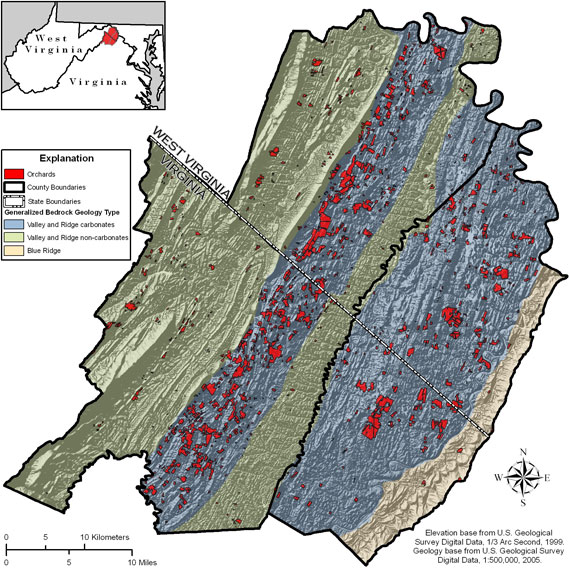
The digital data set of orchard locations (Figure 2) was used to aid in the assessment of the likely occurrence and distribution of arsenical pesticide residues in surface soils. The orchard locations in Figure 2 are shown in relation to bedrock geologic units in the region. Most areas of orchard cultivation were sited in areas overlying carbonate bedrock in the Valley and Ridge province.
 |
||
| Figure 2. Distribution of orchards in the Great Valley Region study area of Clarke and Frederick Counties Virginia, and Berkeley and Jefferson Counties, West Virginia believed to have been under cultivation between 1925 and 1960 when arsenical pesticides were likely used. The shaded relief was created using a digital elevation model with a 30 meter resolution. The azimuth of the relief is 315 degrees (NW) and the altitude angle is 45 degrees. | ||
The spatial database of orchard areas was compiled from USGS 7.5 minute series topographical maps covering the study area. Maps for each quad area were chosen based upon their publication date's proximity to the time period of extensive arsenical pesticide usage. The maps chosen were published between 1943 and 1972 and all have a scale of 1:24,000.
Orchard areas identified on the topographic maps were traced, scanned, and then geographically referenced using the 1983 North American Datum. The orchard areas were then digitized to create a spatial database of sites, which was projected into the Universal Transverse Mercator Zone 18 North projection. The final orchard data set includes several descriptive attributes that identify each orchard's polygon (Table 1).
| Attribute | Name of Field in Table | Description |
|---|---|---|
| USGS Quad | USGS Quad | This attribute identifies the U.S. Geological Survey 7.5’ quadrangle in which the orchard resides. |
| Quadrangle Publication Year | Quad_Year | This attribute identifies the publication year of the orchard’s quadrangle map used to define location. |
| State | State | This attribute identifies the State location of each orchard. |
| County | County | This attribute identifies the County location of each orchard. |
| Area | Area | This attribute represents the area of the orchard in square meters. |
A digital data set that contains the orchards for the Great Valley region study area is available on the World Wide Web at URL https://pubs.usgs.gov/of/2006/1330/shapefile/ as an ArcView shape file. The metadata (documentation) of the orchard data set is also available with the digital data set. The metadata provides detailed information on data quality, spatial-data organization, spatial reference, spatial entities and attributes, and other aspects of the data set. Any use of trade, product, or firm names is for descriptive purposes only and does not imply endorsement by the U.S. Government.
For more information on the orchard digital data set or its associated study, please contact:
Bradley W. Reed
U.S. Geological Survey
954 National Center
Reston, VA 20192
E-mail: breed@usgs.gov
Gilpin R. Robinson, Jr.
U.S. Geological Survey
954 National Center
Reston, VA 20192
E-mail: grobinso@usgs.gov
Buckingham, D.A., and Brooks, W.E., 2001, Arsenic statistics, in Kelly, T., Buckingham, D.A., DiFrancesco, C., Porter, K., Goonan, T., Sznopek, J., Berry, C., and Crane, M., Historical statistics for mineral and material commodities in the United States: U.S. Geological Survey Data Series 140. Available at http://minerals.usgs.gov/ds/2005/140/arsenic.pdf (Verified 11 Sept. 2006).
D'Angelo, D., Norton, S.A., and Loiselle, M.C., 1996, Historical uses and fate of arsenic in Maine: Water Research Institute Completion Report 1986. University of Maine, Orono, Maine.
Jones, J.S., and Hatch, M.B., 1937, The significance of inorganic spray residue accumulations in orchard soils: Soil Sciences, v. 44, p. 37-61.
Peryea, F.J, 1998, Historical use of lead arsenate insecticides, resulting soil contamination and implications for soil remediation [Online]: Proceedings of the 16th World Congress of Soil Science, 25th, Montpellier, France, 24-25 August 1998. Available at http://natres.psu.ac.th/Link/SoilCongress/en/symt25.htm (Verified 11 Sept. 2006).
Shepard, H.H., 1939, The chemistry and toxicology of insecticides: Burgess, Minneapolis, MN.
Veneman, P.L.M., Jr., Murray, J.R., and Baker, J.H., 1983, Spatial distribution of pesticide residues in a former apple orchard: Journal of Environmental Quality, v. 12, p. 101-104.

![]() U.S. Department of the Interior |
U.S. Geological Survey
U.S. Department of the Interior |
U.S. Geological Survey
URL: https://pubsdata.usgs.gov/pubs/fs/2006/3134/index.html
Page Contact Information: Publishing Services
Page Last Modified: 17:23:45 Tue 29 Nov 2016
