Fact Sheet 2006-3141
U.S. GEOLOGICAL SURVEY
Fact Sheet 2006-3141
By Ben W. Kennedy, Dennis C. Trabant, and Lawrence R. Mayo

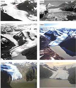
The Portage Glacier, in south-central Alaska, is viewed by thousands of visitors annually who come to the U.S. Forest Service Begich, Boggs Visitor Center located on the road system between Anchorage and Whittier, Alaska. During the past century, the terminus of the glacier has retreated nearly 5 kilometers to its present location (fig. 1). Like other glaciers that terminate in water, such as Columbia Glacier near Valdez or Mendenhall Glacier near Juneau, Portage Glacier has experienced accelerated retreats in recent decades that likely were initially triggered by climate change begun at the end of the Little Ice Age in the mid-1800s and subsequently controlled in recent history primarily by calving of the glacier terminus. Photographic records of the terminus covering 1914 until present day track the patterns of retreat. These data, coupled with USGS climate information collected from the southern end of the ice field, provide insight to the patterns of retreat that might be observed in the future.
During the late 1800s and early 1900s, Portage Glacier terminated on land at the western end of Portage Lake, filling Portage Lake with ice (Photo Plate 1914). Since the early 1900s, the glacier has receded, leaving Portage Lake in the scoured basin. The initial retreat of the glacier coincides with known climate warming associated with the end of the Little Ice Age (circa mid-19th century). As the glacier receded, its land-based terminus retreated into proglacial Portage Lake and changed from its relatively stable land-based environment to an unstable calving environment. The most rapid recession of some 140 to 160 meters per year occurred between 1939 (Photo Plate, 1939) and 1950, when water depth at the terminus was at its maximum—roughly 200 meters. Recession continued through the 1970s and 1980s (Photo Plate, 1972, 1984) until by late 1999, Portage Glacier had receded almost 5 kilometers, to a more stable position at the eastern end of Portage Lake (Photo Plate, 1999). The retreat was driven primarily by calving of unstable ice at the glacier terminus into Portage Lake. Ice loss resulting from increased melting of the glacier surface during the past century-long general warming trend contributed to glacier retreat, but to a lesser extent. Today, the terminus of Portage Glacier remains close to its 1999 location (Photo Plate, 2006).
Future changes of the terminus of Portage Glacier will depend on a variety of factors. However, present scientific theory (Meier and Post, 1987, Trabant and others, 2003) suggests that calving glaciers cycle between advance and retreat patterns; with rapid retreats, followed by stable retracted positions, slow advances, and then stable extended positions that are not directly related to climate change. Thus, based on its history to date, and if such a pattern holds for Portage Glacier, the glacier may now be in its stable retracted position and could eventually begin a slow advance. However, for a glacier to advance, annual net balance—the amount of new snow and ice added to the glacier minus the amount of glacier melt—must be positive. As a rule of thumb for valley glaciers, net balance is positive when annual snow and ice accumulation occurs over more than 60–70 percent of the entire glacier area. Such accumulation occurs on the glacier above the end-of-summer snow-line altitude, recently measured by USGS at 1,000 meters in altitude. Only 50 percent (not the rule-of-thumb 60–70 percent) of Portage Glacier is more than 1,000 meters in altitude, thus, Portage Glacier may slowly thin and recede rather than experience a slow advance.
Regardless of predictions, the position of the Portage Glacier terminus has remained relatively unchanged at the eastern end of Portage Lake for the last 7 years and continues to provide visitors with a spectacular view of glacier ice.
Barnes, F.F., 1943, Geology of the Portage Pass area, Alaska: U.S. Geological Survey Bulletin 926–D, p. 211–235.
Crossen, K.J., 1992, Guide to the Little Ice Age landforms and glacial dynamics in Portage Valley and Portage Pass: Alaska Geological Society, 46 p.
Mayo, L.R., Zenone, C., and Trabant, D.C., 1977, Reconnaissance hydrology of Portage Glacier basin, Alaska: U.S. Geological Survey Hydrologic Investigations Atlas HA–583, 2 sheets.
Meier, M.F., and Post, Austin, 1987, Fast tidewater glaciers: Journal of Geophysical Research, v. 92, No. B9, p. 9051-9058.
Schmidt, R.A.M., 1961, Recession of Portage Glacier, Alaska, in Geological Survey research 1961: U.S. Geological Survey Professional Paper 424–D, p. D202–D203.
Trabant, D.C., Krimmel, R.M., and Post, Austin, 1990, A preliminary forecast of the advance of Hubbard Glacier and its influence on Russell Fjord, Alaska: U.S. Geological Survey, Water-Resources Investigations Report 90-4172, 34 pp.
Trabant, D.C., Krimmel, R.M., Echelmeyer, K.A., Zirnheld, S.L., and Elsberg, D.H., 2003, The slow advance of a calving glacier: Hubbard Glacier, Alaska, U.S.A.: Annals of Glaciology, Volume 36, Number 1, pp. 45-50(6).
Director
U.S. Geological Survey
Alaska Science Center
4230 University Drive
Suite 201
Anchorage, AK 99508-4664
Or visit the USGS Alaska Science
Center homepage on the World
Wide Web at: http://alaska.usgs.gov/
This report is available online in Portable Document Format (PDF). If you do not have the Adobe Acrobat PDF Reader, it is available for free download from Adobe Systems Incorporated.
Document Accessibility: Adobe Systems Incorporated has information about PDFs and the visually impaired. This information provides tools to help make PDF files accessible. These tools convert Adobe PDF documents into HTML or ASCII text, which then can be read by a number of common screen-reading programs that synthesize text as audible speech. In addition, an accessible version of Acrobat Reader 7.0 for Windows (English only), which contains support for screen readers, is available. These tools and the accessible reader may be obtained free from Adobe at Adobe Access.

![]() U.S.
Department of the Interior | U.S. Geological
Survey
U.S.
Department of the Interior | U.S. Geological
Survey
Persistent URL: https://pubs.water.usgs.gov/fs20063141
Page Contact Information: USGS Publishing Network
Page Last Modified: Tuesday, 29-Nov-2016 17:24:10 EST
