Fact Sheet 2006–3145
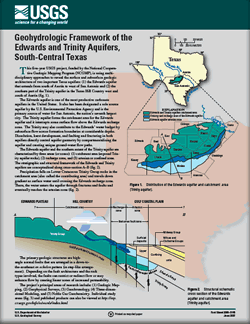 
This five-year USGS project, funded by the National Cooperative Geologic Mapping Program, is using multidisciplinary approaches to reveal the surface and subsurface geologic architecture of two important Texas aquifers: (1) the Edwards aquifer that extends from south of Austin to west of San Antonio and (2) the southern part of the Trinity aquifer in the Texas Hill Country west and south of Austin. The project’s principal areas of research include: Geologic Mapping, Geophysical Surveys, Geochronology, Three-dimensional Modeling, and Noble Gas Geochemistry. The Edwards aquifer is one of the most productive carbonate aquifers in the United States. It also has been designated a sole source aquifer by the U.S. Environmental Protection Agency and is the primary source of water for San Antonio, America’s eighth largest city. The Trinity aquifer forms the catchment area for the Edwards aquifer and it intercepts some surface flow above the Edwards recharge zone. The Trinity may also contribute to the Edwards’ water budget by subsurface flow across formation boundaries at considerable depths. Dissolution, karst development, and faulting and fracturing in both aquifers directly control aquifer geometry by compartmentalizing the aquifer and creating unique ground-water flow paths. |
Posted August 2007 |
Blome, C.D., Faith, J.R., and Ozuna, G.B., 2007, Geohydrologic Framework of the Edwards and Trinity aquifers, south-central Texas: U.S. Geological Survey Fact Sheet 2006-3145, 6 p.

![]() U.S. Department of the Interior | U.S. Geological Survey
U.S. Department of the Interior | U.S. Geological Survey
URL: http://pubsdata.usgs.gov/pubs/fs/2006/3145/index.html
Questions or Assistance: Contact USGS
Last modified: Tuesday, 29-Nov-2016 17:24:56 EST
