Fact Sheet 2008–3024
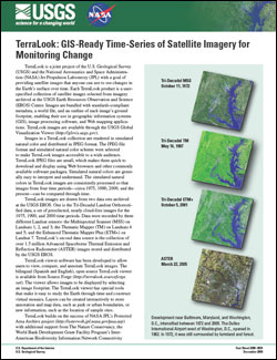
SummaryTerraLook is a joint project of the U.S. Geological Survey (USGS) and the National Aeronautics and Space Administration (NASA) Jet Propulsion Laboratory (JPL) with a goal of providing satellite images that anyone can use to see changes in the Earth’s surface over time. Each TerraLook product is a user-specified collection of satellite images selected from imagery archived at the USGS Earth Resources Observation and Science (EROS) Center. Images are bundled with standards-compliant metadata, a world file, and an outline of each image’s ground footprint, enabling their use in geographic information systems (GIS), image processing software, and Web mapping applications. TerraLook images are available through the USGS Global Visualization Viewer (http://glovis.usgs.gov). |
First posted December 16, 2008 For additional information contact: Part or all of this report is presented in Portable Document Format (PDF); the latest version of Adobe Reader or similar software is required to view it. Download the latest version of Adobe Reader, free of charge. |
U.S. Geological Survey, 2008, TerraLook: GIS-ready time-series of satellite imagery for monitoring change: U.S. Geological Survey Fact Sheet 2008-3024, 2 p.

![]() U.S. Department of the Interior | U.S. Geological Survey
U.S. Department of the Interior | U.S. Geological Survey
URL: http://pubsdata.usgs.gov/pubs/fs/2008/3024/index.html
Questions or Assistance: Contact USGS
Last modified: Tuesday, 29-Nov-2016 18:22:58 EST
