Fact Sheet 2008–3069
Abstract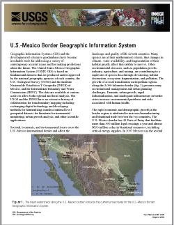
Geographic Information Systems (GIS) and the development of extensive geodatabases have become invaluable tools for addressing a variety of contemporary societal issues and for making predictions about the future. The United States-Mexico Geographic Information System (USMX-GIS) is based on fundamental datasets that are produced and/or approved by the national geography agencies of each country, the U.S. Geological Survey (USGS) and the Instituto Nacional de Estadística Y Geografía (INEGI) of Mexico, and the International Boundary and Water Commission (IBWC). The data are available at various scales to allow both regional and local analysis. The USGS and the INEGI have an extensive history of collaboration for transboundary mapping including exchanging digital technology and developing methods for harmonizing seamless national level geospatial datasets for binational environmental monitoring, urban growth analysis, and other scientific applications. |
Version 1.0 Posted October 2008 For additional information contact: Part or all of this report is presented in Portable Document Format (PDF); the latest version of Adobe Reader or similar software is required to view it. Download the latest version of Adobe Reader, free of charge. |
Parcher, J.W., 2008, U.S.-Mexico Border Geographic Information System: U.S. Geological Survey Fact Sheet 2008–3069, 4 p., also available in Spanish.
USGS and INEGI Collaborative Activities
Specific Examples
Summary

![]() U.S. Department of the Interior | U.S. Geological Survey
U.S. Department of the Interior | U.S. Geological Survey
URL: http://pubsdata.usgs.gov/pubs/fs/2008/3069/index.html
Questions or Assistance: Contact USGS
Last modified: Tuesday, 29-Nov-2016 18:21:45 EST
