Fact Sheet 2008-3071
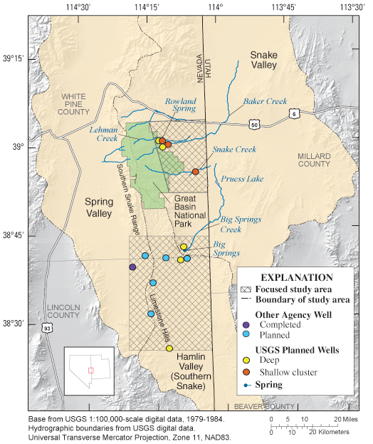
The Secretary of the Interior through the Southern Nevada Public Lands Management Act approved funding for research to improve understanding of hydrologic systems that sustain numerous water-dependent ecosystems on Federal lands in Snake Valley, Nevada. Some of the streams and spring-discharge areas in and adjacent to Great Basin National Park have been identified as susceptible to ground-water withdrawals (Elliott and others, 2006) and research has shown a high potential for ground-water flow from southern Spring Valley into southern Snake Valley through carbonate rocks that outcrop along a low topographic divide known as the Limestone Hills (Welch and others, 2007).
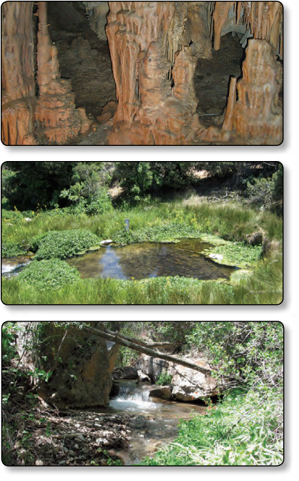
Comprehensive geologic, hydrologic, and chemical information will be collected and analyzed to assess the hydraulic connection between basin-fill aquifers and surface-water resources, water-dependent ecological features, and the regional carbonate-rock aquifer, the known source of many high-discharge springs. Understanding these connections is important because proposed projects to pump and export ground water from Spring and Snake Valleys in Nevada may result in unintended capture of water currently supplying springs, streams, wetlands, limestone caves, and other biologically sensitive areas (fig. 1). The methods that will be used in this study may be transferable to other areas in the Great Basin.
The National Park Service, Bureau of Land Management, U.S. Fish and Wildlife Service, and U.S. Forest Service submitted the proposal for funding this research to facilitate science-based land management. Scientists from the U.S. Geological Survey (USGS) Water Resources and Geologic Disciplines, and the University of Nevada, Reno, will accomplish four research elements through comprehensive data collection and analysis that are concentrated in two distinct areas on the eastern and southern flanks of the Snake Range (fig. 2). The projected time line for this research is from July 2008 through September 2011.
These properties influence the ground-water flow direction and magnitude, the potential for ground-water/surface-water interactions, and the locations and types of ground-water discharge. Element 1 will be accomplished by collecting new and compiling existing geologic and hydrologic data from wells, new geologic field mapping, correlating geologic maps with existing geophysical surveys, and developing hydrofacies maps.
The potential and rate of exchange of water between the flow systems are a function of the degree of hydraulic connection and difference between river stage and aquifer heads. Lehman, Baker, and Snake Creeks exhibit highly variable gain and loss conditions. Because these conditions occur largely in, or in close proximity to Great Basin National Park, a better understanding of the spatial and temporal ground-water/surface-water relations along these creeks are of interest. Element 2 will be accomplished by heat tracing, aquifer testing, and seepage runs.
The water chemistry of streams, springs, and wells can provide insight as to the sources of water to springs and, consequently, their susceptibility to changes in either the ground- or surface-water systems. Element 3 will be accomplished by
evaluating the sources of water to springs
using the chemical mixing model, NETPATH.
The magnitude and direction of subsurface flow through the Limestone Hills will be quantified by delineation of ground-water divides in the study area and reliable estimates of the hydraulic gradient, effective thickness of the permeable carbonate rocks, and effective hydraulic conductivity of these permeable rocks. Element 4 will be accomplished by applying the Darcy Equation to refined hydraulic property and gradient estimates.
The results of these research elements will be summarized in a multi-chapter USGS Scientific Investigations Report. The results of this study will benefit the National Park Service, Bureau of Land Management, U.S. Fish and Wildlife Service, U.S. Forest Service, Nevada and Utah State agencies, as well as interested stakeholders by providing relevant hydrologic data to better quantify the current hydrologic condition, and proactively assess potential effects on ground and surface-water systems from proposed large-scale ground-water withdrawals. This study is aligned with the USGS science strategy goal of informing the public and decision makers about the status of freshwater resources across America (U.S. Geological Survey, 2007).
Elliott, P.E., Beck, D.A., and Prudic, D.E., 2006, Characterization of surface-water resources in the Great Basin National Park and their susceptibility to ground-water withdrawals in adjacent valleys, White Pine County, Nevada: U.S. Geological Survey Scientific Investigations Report 2006-5099, 156 p.
U.S. Geological Survey, 2007, Facing tomorrow’s challenges—U.S. Geological Survey science in the decade 2007–2017: U.S. Geological Survey Circular 1309, 67 p.
Welch, A.H., Bright, D.J., and Knochenmus, L.A., eds., 2007, Water resources of the Basin and Range carbonate-rock aquifer system, White Pine County, Nevada, and adjacent areas in Nevada and Utah: U.S. Geological Survey Scientific Investigations Report 2007-5261, 96 p.
This report is available online in Portable Document Format (PDF). If you do not have the Adobe Reader, it is available for free download from Adobe Systems Incorporated.
Document Accessibility: Adobe Systems Incorporated has information about PDFs and the visually impaired. This information provides tools to help make PDF files accessible. These tools convert Adobe PDF documents into HTML or ASCII text, which then can be read by a number of common screen-reading programs that synthesize text as audible speech. In addition, an accessible version of Adobe Reader 8.0 for Windows (English only), which contains support for screen readers, is available. These tools and the accessible reader may be obtained free from Adobe at Adobe Access.
For more information about USGS activities in Nevada, visit the USGS Nevada Science Center home page.

![]() U.S. Department of the Interior | U.S. Geological Survey
U.S. Department of the Interior | U.S. Geological Survey
URL: https://pubs.usgs.gov/fs/2008/3071
Page Contact Information: Publications Team
Page Last Modified:
Tuesday, 29-Nov-2016 18:21:59 EST
