Fact Sheet 2008-3103
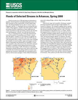
Floods can cause loss of life and extensive destruction to property. Monitoring floods and understanding the reasons for their occurrence are the responsibility of many Federal agencies. The National Weather Service, the U.S. Army Corps of Engineers, and the U.S. Geological Survey are among the most visible of these agencies. Together, these three agencies collect and analyze floodflow information to better understand the variety of mechanisms that cause floods, and how the characteristics and frequencies of floods vary with time and location. The U.S. Geological Survey (USGS) has monitored and assessed the quantity of streamflow in our Nation’s streams since the agency’s inception in 1879. Because of ongoing collection and assessment of streamflow data, the USGS can provide information about a range of surface-water issues including the suitability of water for public supply and irrigation, the effects of agriculture and urbanization on streamflow, and statistically analyze streamflow data for magnitude and frequency information for floods. In Arkansas, the major supporters of the streamflow-gaging network are the U.S. Army Corps of Engineers, Arkansas Natural Resources Commission, Arkansas Department of Environmental Quality, and Arkansas Geological Survey. As part of its streamflow-data collection activities, the USGS measured streamflow in multiple streams during extreme flood events in Arkansas in the spring of 2008. The fact sheet describes the floods that occurred in Arkansas during March and April 2008 and assigns recurrence intervals to floods at 19 different streamflow-gaging stations. |
First posted Febraury 9, 2009 Part or all of this report is presented in Portable Document Format (PDF); the latest version of Adobe Reader or similar software is required to view it. Download the latest version of Adobe Reader, free of charge. |
Funkhouser, J.E., and Eng, Ken, 2009, Floods of selected streams in Arkansas, spring 2008: U.S. Geological Survey Fact Sheet 2008-3103, 4 pages.

![]() U.S. Department of the Interior |
U.S. Geological Survey
U.S. Department of the Interior |
U.S. Geological Survey
URL: http://pubsdata.usgs.gov/pubs/fs/2008/3103/index.html
Page Contact Information: GS Pubs Web Contact
Page Last Modified: Tuesday, 29-Nov-2016 18:23:11 EST
