Fact Sheet 2009–3055
OrthoimageryOrthorectified digital aerial photographs and satellite images of 1-meter (m) pixel resolution or finer make up the orthoimagery component of The National Map. The process of orthorectification removes feature displacements and scale variations caused by terrain relief and sensor geometry. The result is a combination of the image characteristics of an aerial photograph or satellite image and the geometric qualities of a map. These attributes allow users to:
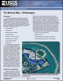
The standard digital orthoimage is a 1-m or finer resolution, natural color or color infra-red product. Most are now produced as GeoTIFFs and accompanied by a Federal Geographic Data Committee (FGDC)-compliant metadata file. The primary source for 1-m data is the National Agriculture Imagery Program (NAIP) leaf-on imagery. The U.S. Geological Survey (USGS) utilizes NAIP imagery as the image layer on its "Digital- Map"—a new generation of USGS topographic maps (http://nationalmap.gov/digital_map). However, many Federal, State, and local governments and organizations require finer resolutions to meet a myriad of needs. Most of these images are leaf-off, natural-color products at resolutions of 1-foot (ft) or finer. |
Reprinted April 2010 First Posted July 10, 2009 For additional information contact: Part or all of this report is presented in Portable Document Format (PDF); the latest version of Adobe Reader or similar software is required to view it. Download the latest version of Adobe Reader, free of charge. |
Mauck, J., Brown, K., Carswell Jr., W.J., 2009, The National Map—Orthoimagery: U.S. Geological Survey Fact Sheet 2009-3055, 4 p.

![]() U.S. Department of the Interior |
U.S. Geological Survey
U.S. Department of the Interior |
U.S. Geological Survey
URL: http://pubsdata.usgs.gov/pubs/fs/2009/3055/index.html
Page Contact Information: GS Pubs Web Contact
Page Last Modified: Tuesday, 29-Nov-2016 17:33:46 EST
