Fact Sheet 2009–3060
|
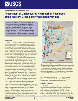
IntroductionThe U.S. Geological Survey (USGS) recently completed an assessment of the undiscovered, technically recoverable oil and gas resources of the Western Oregon and Washington Province. The province includes all of Oregon and Washington north of the Klamath Mountains and west of the crest of the Cascade Range. It extends offshore to the 3-mi limit of State waters on the west and to the International Boundary in the Straits of Juan de Fuca and Canada on the north. The province measures about 450 mi north-south and 50 to 160 mi east-west, encompassing more than 51,000 mi2.The assessment of the Western Oregon and Washington Province is geology based and used the total petroleum system (TPS) concept. The geologic elements of a TPS include hydrocarbon source rocks (source rock maturation and hydrocarbon generation and migration), reservoir rocks (quality and distribution), and traps for hydrocarbon accumulation. Using these geologic criteria, the USGS assessment team defined two conventional and one unconventional (continuous) total petroleum systems with one assessment unit (AU) in each TPS: (1) the Cretaceous-Tertiary Composite TPS and the Western Oregon and Washington Conventional Gas AU, (2) the Tertiary Marine TPS and the Tertiary Marine Gas AU, and (3) the Tertiary Coalbed Gas TPS and the Eocene Coalbed Gas AU, in which a cell-based methodology was used.
|
First posted August 24, 2009 For further information: Part or all of this report is presented in Portable Document Format (PDF); the latest version of Adobe Reader or similar software is required to view it. Download the latest version of Adobe Reader, free of charge. |
Brownfield, M.E., Cook, T.A., Klett, T.R., Pollastro, R.M., and Schenk, C.J., 2009, Assessment of undiscovered hydrocarbon resources of the Western Oregon and Washington province: U.S. Geological Survey Fact Sheet 2009-3060, 2 p.
Introduction
Resource Summary
For Additional Information
Western Oregon and Washington Province Assessment Team
References

![]() U.S. Department of the Interior |
U.S. Geological Survey
U.S. Department of the Interior |
U.S. Geological Survey
URL: http://pubsdata.usgs.gov/pubs/fs/2009/3060/index.html
Page Contact Information: GS Pubs Web Contact
Page Last Modified: Tuesday, 29-Nov-2016 17:34:24 EST