Skip Links

USGS - science for a changing world

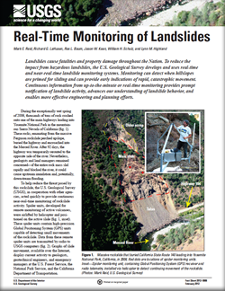
Fact Sheet 2012–3008

Real-Time Monitoring of Landslides

Mark E. Reid, Richard G. LaHusen, Rex L. Baum, Jason W. Kean, William H. Schulz, and Lynn M. Highland

Thumbnail of and link to Fact Sheet PDF (9 MB)

Landslides cause fatalities and property damage throughout the Nation. To reduce the impact from hazardous landslides, the U.S. Geological Survey develops and uses real-time and near-real-time landslide monitoring systems. Monitoring can detect when hillslopes are primed for sliding and can provide early indications of rapid, catastrophic movement. Continuous information from up-to-the-minute or real-time monitoring provides prompt notification of landslide activity, advances our understanding of landslide behavior, and enables more effective engineering and planning efforts.

First posted February 16, 2012

For additional information contact:
National Landslide Information Center
U.S. Geological Survey
Federal Center, Box 25046, MS 966
Denver, CO 80225
landslides.usgs.gov

This report is presented in Portable Document Format (PDF); the latest version of Adobe Reader or similar software is required to view it. Download the latest version of Adobe Reader, free of charge.


Suggested citation:

Reid, M.E., LaHusen, R.G., Baum, R.L., Kean, J.W., Schulz, W.H., and Highland, L.M., 2012, Real-time monitoring of landslides: U.S. Geological Survey Fact Sheet 2012-3008, 4 p.


Accessibility FOIA Privacy Policies and Notices

Take Pride in America logo USA.gov logo U.S. Department of the Interior | U.S. Geological Survey
URL: http://pubsdata.usgs.gov/pubs/fs/2012/3008/index.html
Page Contact Information: GS Pubs Web Contact
Page Last Modified: Tuesday, 29-Nov-2016 18:28:10 EST