Fact Sheet 2013–3005
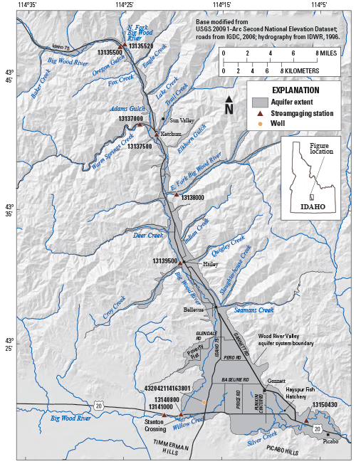
Figure 1. Locations of communities, selected U.S. Geological Survey streamgaging stations, and other features, Wood River Valley, south-central Idaho (modified from Bartolino and Adkins, 2012). The U.S. Geological Survey (USGS), in collaboration with the Idaho Department of Water Resources (IDWR), will use the current understanding of the Wood River Valley aquifer system to construct a MODFLOW numerical groundwater-flow model to simulate potential anthropogenic and climatic effects on groundwater and surface-water resources. This model will serve as a tool for water rights administration and water-resource management and planning. The study will be conducted over a 3-year period from late 2012 until model and report completion in 2015. The Wood River ValleyThe population of Blaine County in south-central Idaho has nearly quadrupled from 1970 to 2010; most of the growth has occurred in the Wood River Valley in the northern part of the county. Because the entire population of the valley depends on groundwater for domestic supply, from either domestic or municipal-supply wells, this growth has caused concern about the long-term sustainability of the groundwater resource (Bartolino and Adkins, 2012). The upper Wood River Valley is more developed than the lower valley and contains the incorporated communities of Sun Valley, Ketchum, Hailey, and Bellevue (fig. 1). The lower Wood River Valley is dominated by farms and ranches (irrigated by groundwater and diverted surface water), and contains the small communities of Gannett and Picabo. A number of tributary canyons to the main valley have been developed over the last 50 years (Bartolino and Adkins, 2012). The Aquifer SystemThe Wood River Valley aquifer system is composed primarily of Quaternary-age sediment and basalt. This material constitutes the three components of the aquifer system: a single unconfined aquifer underlying the entire valley, a deeper confined aquifer present to the south of Baseline Road (fig. 1), and a confining layer separating the two aquifers. The confining layer thickens toward the south and generally, as landsurface altitude decreases in the same direction, the water-level surface rises above land surface so that wells flow under artesian pressure. South and east of Gannett the confining unit thins and disappears over the basalt. 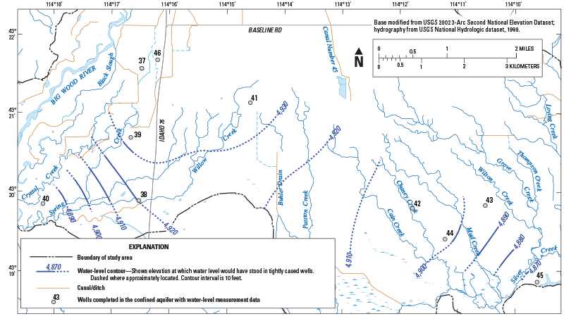
Figure 2. Groundwater levels in the confined aquifer, Wood River Valley aquifer system in October 2006 (modified from Skinner and others, 2007). The sediment and basalt can be divided into three hydrogeologic units: a coarse-grained sand and gravel unit, a fine-grained silt and clay unit, and a basalt unit. Although the three units exist throughout the aquifer system, the two aquifers are primarily composed of coarse-grained sediment and basalt and the confining unit is mostly composed of the fine-grained sediment. The sediments are largely derived from two episodes of glaciation in the surrounding mountains and upper reaches of tributary canyons. The basalt unit contains two flows of different ages, and is limited to the southeastern part of the Wood River Valley. In some areas, the underlying bedrock may be hydraulically connected to the sediment and basalt units; however, the bedrock likely contains a small percentage of available water in the aquifer system. These bedrock aquifers probably are separate from the Wood River Valley aquifer system. Generally, groundwater movement through the Wood River Valley aquifer system is relatively straightforward. Groundwater under unconfined conditions moves down-valley to the south, where it either enters the deeper confined aquifer or remains in the shallow unconfined aquifer; the two aquifers appear to hydraulically reconnect in the area south of Gannett. A groundwater budget by Bartolino (2009) indicates that recharge primarily is from precipitation or seepage from streams, and discharge primarily is through springs and seeps to streams, pumpage, or subsurface outflow from the aquifer system. The rerouting of surface water into a network of irrigation canals in the late 19th century, construction of groundwater wells, and increased demand have affected groundwater flow, but the overall direction of groundwater movement remains down the topographic gradient and toward the eastern outlet of the valley at Picabo and western outlet near Stanton Crossing (figs. 1 and 2). Depth to groundwater in the upper valley commonly is less than 10 ft, and increases southward to approximately 90 ft; water levels in wells completed in the unconfined aquifer in the lower valley range from less than 10 ft to approximately 150 ft below land surface. Wells completed in the confined aquifer are under artesian pressure and flow where the water-level surface is above land surface (Skinner and others, 2007). Hydrologic TrendsA USGS report by Skinner and others (2007) verified statistically significant declining trends in mean annual water levels in three wells that seem representative of general conditions in the aquifer system. Two of these wells are completed in the unconfined aquifer and one well is in the confined aquifer (fig. 3): all three have more than 50 years of measurement data. 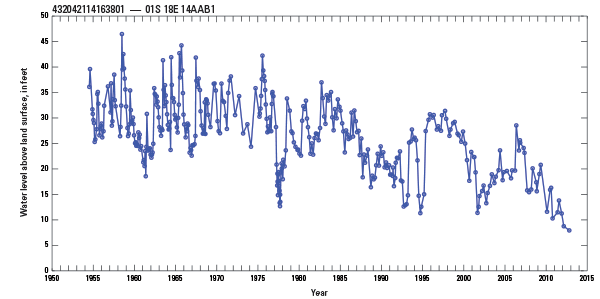
Figure 3. Depth to water for well 432042114163801 completed in the confined aquifer of the Wood River Valley aquifer system, July 1954–February 2012. A water level above land surface indicates a flowing well. Skinner and others (2007) also analyzed streamflow trends for three streamgaging stations in the Wood River Valley (fig. 1). The findings included:
Groundwater Modeling: A Tool for Understanding and Managing the ResourceIn the most general terms, a model is a simplified representation of the appearance or operation of a real object or system. Groundwater-flow models attempt to reproduce, or simulate, the processes of a real aquifer system by solving a series of mathematical equations. Groundwater-flow models are usually constructed by representing the geology of the groundwater system as a series of rectangular three-dimensional blocks or model cells surrounded by a boundary (figs. 4 and 5). 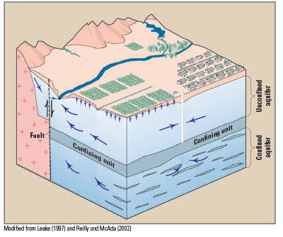
Figure 4. Block diagram of part of a hypothetical basin-fill groundwater system. The blue arrows show the direction of groundwater flow. Among the features shown are an unconfined aquifer overlying a confining unit and confined aquifer, a gaining stream, infiltration from irrigated agriculture, and mountain-front recharge. 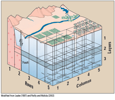
Figure 5. Block diagram of part of a hypothetical basin-fill groundwater system with some model cells shown superimposed. The model cells cover the entire simulated groundwater system. A numerical computer model, in this case MODFLOW, is a program containing a number of equations that represent groundwater flow between the model cells. As the equations are solved, the program accounts for the flow of water through the model domain and for each cell; a model calculates the volume of water flowing horizontally and vertically between the cells and any changes in the volume of water stored in each cell. By applying the basic laws of physics and reasonably representing the actual groundwater system in the model cells and boundaries, a groundwater-flow model can provide an accurate, quantitative depiction of the relations between groundwater flow-system stresses (such as pumpage) and responses (such as water-level declines). This understanding enables forecasts of future hydrologic conditions in response to changes in recharge, discharge, or varying management scenarios. Such forecasts inherently contain some uncertainty because of sparse or inaccurate data, errors in scientists’ understanding of the system, and poor estimates of future conditions. Despite such uncertainties, groundwater-flow models often represent the best available tool for management decisions (Alley and others, 1999). One of the keys to a successful groundwater-flow model that produces accurate forecasts is the appropriate representation of important aspects of the physical system. The selection of these aspects depends, in part, on the objectives of the modeling project. These modeling objectives also influence the extent and depth of the modeled area, the size and shape of the model cells and layers, the methods used to represent the boundary conditions of the system, and the use of any specialized techniques or equations to address specific flow conditions or processes. The Wood River Valley groundwater-flow model will be designed to further the basic understanding of the aquifer system, and ultimately to examine effects on the groundwater system and its interaction with the Big Wood River due to changes in water use, recharge, or discharge. Additionally, by virtue of the attempt to mathematically represent the groundwater-flow system, the model can be used to evaluate how well components of the system are understood and which components have the most effect on calculations. This analysis then can be used to guide the collection of additional data that will most improve the understanding of the Wood River Valley aquifer system. The Collaborative USGS-IDWR Groundwater-Flow Model Project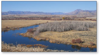
Silver Creek on the Nature Conservancy Silver Creek Preserve, Idaho. View is from the Picabo Hills looking north up the Wood River Valley. The low hills to the right (east) are the southeastern edge of the Pioneer Mountains, the snow covered peaks in the background are in the Smokey Mountains. The valley bottom visible in the medium to far is the Bellevue Fan. Photograph taken November 19, 2004. The USGS began cooperative groundwater studies in the Wood River Valley in 1928 with one of the precursor agencies to the IDWR (Stearns and others, 1936). Since then, the USGS and IDWR have cooperated with each other, numerous local governments, and other entities to understand the water resources of the valley. The latest effort began in 2004 when the USGS, in cooperation with Blaine County, City of Hailey, City of Ketchum, The Nature Conservancy, City of Sun Valley, Sun Valley Water and Sewer District, Blaine Soil Conservation District, City of Bellevue, and Citizens for Smart Growth undertook a four-phase, multiyear effort to better understand the groundwater system and provide information for scientifically-informed decisions. The USGS, in collaboration with the IDWR, will incorporate this improved understanding of the Wood River Valley aquifer system into a groundwater-flow model that will serve as a tool for water-rights administration and water-resource management and planning. The 3-year study will be from late 2012 through 2015. Additional data collection, including water-level monitoring and streamflow measurements, will be done in 2013. The numerical groundwater-flow model will be constructed using MODFLOW to simulate potential anthropogenic and climatic effects on groundwater and surface-water resources. A USGS report will be published to describe numerical model construction and limitations, as well as results from several simulations that represent a range of potential anthropogenic activities (formulated in consultation with stakeholders) and hydrologic conditions. The documented model will be published by the USGS and made publically available through a USGS website. A Technical Advisory Committee is planned to provide for transparency in model development and to serve as a vehicle for stakeholder input. Technical representation will include interested parties such as water-user groups and current USGS cooperating organizations in the Wood River Valley. References CitedAlley, W.M., Reilly, T.E., and Franke, O.L., 1999, Sustainability of ground-water resources: U.S. Geological Survey Circular 1186, 79 p. (Also available at http://pubs.er.usgs.gov/publication/cir1186.) Bartolino, J.R., 2009, Ground-water budget for the Wood River Valley aquifer system, south-central Idaho: U.S. Geological Survey Scientific Investigations Report 2009-5016, 36 p. (Also available at https://pubs.usgs.gov/sir/2009/5016/.) Bartolino, J.R., and Adkins, C.B., 2012, Hydrogeologic framework of the Wood River Valley aquifer system, south central Idaho: U.S. Geological Survey Scientific Investigations Report 2012–5053, 46 p., 1 plate in pocket. (Also available at https://pubs.usgs.gov/sir/2012/5053/.) Leake, S.A., 1997, Modeling ground-water flow with MODFLOW and related programs: U.S. Geological Survey Fact Sheet 121–97, 4 p. (Also available at https://pubs.usgs.gov/fs/FS-121-97/.) Reilly, T.E., and McAda, D.P., 2002, Ground-water-flow models and how they are used to study the basin, in Bartolino, J.R., and Cole, J.C., 2002, Ground-water resources of the middle Rio Grande Basin, New Mexico: U.S. Geological Survey Circular 1222, p. 102-103. (Also available at http://pubs.er.usgs.gov/usgspubs/cir/cir1222.) Skinner, K.D., Bartolino, J.R., and Tranmer, A.W., 2007, Water-resource trends and comparisons between partial development and October 2006 hydrologic conditions, Wood River Valley, south-central Idaho: U.S. Geological Survey Scientific Investigations Report 2007-5258, 31 p., 4 plates, 1 appendix. (Also available at http://pubs.er.usgs.gov/usgspubs/sir/sir20075258.) Stearns, H.T., Crandall, Lynn, and Steward, W.G., 1938, Geology and groundwater resources of the Snake River Plain in southeastern Idaho: U.S. Geological Survey Water-Supply Paper 774, 268 p., 6 plates in pocket. (Also available at http://pubs.er.usgs.gov/usgspubs/wsp/wsp774.) |
First posted February 19, 2013 For additional information contact: Part or all of this report is presented in Portable Document Format (PDF); the latest version of Adobe Reader or similar software is required to view it. Download the latest version of Adobe Reader, free of charge. |
Bartolino, J.R., and Vincent, Sean, 2013, Groundwater resources of the Wood River Valley, Idaho--A groundwater-flow model for resource management: U.S. Geological Survey Fact Sheet 2013-3005, 4 p.

![]() U.S. Department of the Interior |
U.S. Geological Survey
U.S. Department of the Interior |
U.S. Geological Survey
URL: http://pubsdata.usgs.gov/pubs/fs/2013/3005/index.html
Page Contact Information: GS Pubs Web Contact
Page Last Modified: Tuesday, 29-Nov-2016 17:47:49 EST
