Fact Sheet 2013–3042
|
First posted July 21, 2014 For additional information contact: Part or all of this report is presented in Portable Document Format (PDF). For best results viewing and printing PDF documents, it is recommended that you download the documents to your computer and open them with Adobe Reader. PDF documents opened from your browser may not display or print as intended. Download the latest version of Adobe Reader, free of charge. More information about viewing, downloading, and printing report files can be found here. |
Pugh, A.L., Jackson, B.T., and Miller, Roger, 2014, Arkansas Groundwater-Quality Network: U.S. Geological Survey Fact Sheet 2013–3042, 2 p., https://dx.doi.org/10.3133/fs20133042.
ISSN 2327-6932 (online)
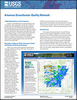
A Web Map Interface for Data Retrieval
Description of National Water Information System and Storage and Retrieval Databases
Data Retrieval
Data Management
Benefits Scientists and Managers
References

![]() U.S. Department of the Interior |
U.S. Geological Survey
U.S. Department of the Interior |
U.S. Geological Survey
URL: http://pubsdata.usgs.gov/pubs/fs/2013/3042/index.html
Page Contact Information: GS Pubs Web Contact
Page Last Modified: Tuesday, 29-Nov-2016 17:51:27 EST