Skip Links

USGS - science for a changing world

Fact Sheet 2014–3045

Prepared in cooperation with the U.S. Army Corps of Engineers

Hydrogeologic Aspects of the Knippa Gap Area in Eastern Uvalde and Western Medina Counties, Texas

By Rebecca B. Lambert, Allan K. Clark, Diana E. Pedraza, and Robert R. Morris

Thumbnail of and link to report PDF (2.66 MB)Abstract

The Edwards aquifer is the primary source of potable water for the San Antonio area in south-central Texas. The Knippa Gap area is a structural low (trough) postulated to channel or restrict flow in the Edwards aquifer in eastern Uvalde and western Medina Counties, Tex. To better understand the function of the Knippa Gap, the U.S. Geological Survey, in cooperation with the U.S. Army Corps of Engineers, developed the first detailed surficial geologic map of the Knippa Gap area with data and information obtained from previous investigations and field observations. A simplified version of the detailed geologic map depicting the hydrologic units, faulting, and structural dips of the Knippa Gap area is provided in this fact sheet. The map shows that groundwater flow in the Edwards aquifer is influenced by the Balcones Fault Zone, a structurally complex area of the aquifer that contains relay ramps that have formed in extensional fault systems and allowed for deformational changes along fault blocks. Faulting in southeast Uvalde and southwest Medina Counties has produced relay-ramp structures that dip downgradient to the structural low (trough) of the Knippa Gap.

First posted June 25, 2014

For additional information, contact:
Director, Texas Water Science Center
U.S. Geological Survey
1505 Ferguson Lane
Austin, Texas 78754–4501
http://tx.usgs.gov/

Part or all of this report is presented in Portable Document Format (PDF). For best results viewing and printing PDF documents, it is recommended that you download the documents to your computer and open them with Adobe Reader. PDF documents opened from your browser may not display or print as intended. Download the latest version of Adobe Reader, free of charge.


Suggested citation:

Lambert, R.B., Clark, A.K., Pedraza, D.E., and Morris, R.R., 2014, Hydrogeologic aspects of the Knippa Gap area in Eastern Uvalde and Western Medina Counties, Texas: U.S. Geological Survey Fact Sheet 2014–3045, 6 p., https://dx.doi.org/10.3133/fs20143045.

ISSN 2327-6916 (print)

ISSN 2327-6932 (online)
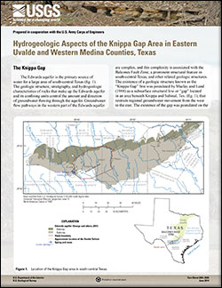


Contents

The Knippa Gap

Sources of Groundwater in the Knippa Gap Area

Complex Structure and Groundwater Flow Paths

References Cited


Accessibility FOIA Privacy Policies and Notices

Take Pride in America logo USA.gov logo U.S. Department of the Interior | U.S. Geological Survey
URL: http://pubsdata.usgs.gov/pubs/fs/2014/3045/index.html
Page Contact Information: GS Pubs Web Contact
Page Last Modified: Tuesday, 29-Nov-2016 17:25:41 EST