Fact Sheet 2014–3098
The Basin Characterization ModelOngoing changes in climate, particularly rises in air temperature, are influencing water resources throughout the world, with shifts in the timing of precipitation, reductions in snowpack (fig. 1), and earlier springtime snowmelt among the most important challenges to water availability (fig. 2). These changes are affecting landscapes, vegetation and animal species, and agriculture, with longer dry seasons, which also create more demand on water resources, more frequent extreme storms, fewer chilling hours, and higher snowlines. 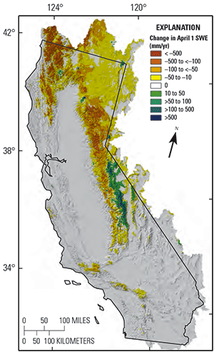 
Figure 1. Change in snow water equivalent (SWE) between 1951–1980 and
1981–2010 in California. These decreases in snowpack reflect world-wide
trends in all but the highest elevations over the last half-century.
Figure 2. Runoff in California, 1981–2010, estimated by using the Basin
Characterization Model, a regional water-balance model used throughout
the Western U.S. and internationally.
To plan for future water- and land-resource demands, resource managers have generally relied on data from globalclimate model projections of precipitation and air temperature trends that lack the detail needed for precision planning at regional and local scales. Recently, the U.S. Geological Survey (USGS) has developed modeling tools that integrate climate data with rigorously developed regional and local environmental data to understand the hydrologic response to climate change and the effects on regional and local watersheds and landscapes. New water-balance modeling tools can provide the types of information managers require to develop climate-change coping strategies: Watershed recharge and runoff quantification—to assess water availability, seasonality, and extremes at the land surface. Climatic water deficit estimation—to assess irrigation demand or landscape stress (climatic water deficit is the amount of water plants would use if it were available). Spatial distribution of hydrologic processes in watersheds— for resource planning and infrastructure development. To develop management strategies for coping with climate change, land and resource managers need hydrologic derivatives of climate, such as recharge and runoff quantities, to assess water availability or climatic water-deficit estimates to assess projected changes in irrigation demand or landscape stress. Regional water-balance modeling can be used effectively to estimate the spatial distribution of these hydrologic variables and can differentiate between recharge and runoff to provide valuable information for resource planning and infrastructure development. The Basin Characterization Model (BCM) is a mathematical computer model that calculates the hydrologic inputs and outputs of a specific landscape area (fig. 3) and is generally run at a monthly timestep for large regions (fig. 1), although daily models have been developed for small watersheds. Scientists divide the landscape into grid cells, each of which uses specific climate data inputs, such as precipitation and air temperature, to solve the water balance for each cell. Model calculations include potential evapotranspiration, calculated from solar radiation with topographic shading and cloudiness; snow, as it accumulates and melts; and excess water moving through the soil profile, which is used to calculate actual evapotranspiration and climatic water deficit—the difference between potential and actual evapotranspiration. Depending on soil properties and the permeability of underlying bedrock, surface water can be classified for each cell as either recharge or runoff. Post-processing calculations are made to estimate baseflow, streamflow, and potential recharge to the groundwater system for watersheds (fig. 4). The model output can define the water balance for any size polygon representing regions or watersheds, or can define the distribution of the various water-balance variables across the landscape. 
Figure 3. The Basin Characterization Model relies on climate input and the rigorous development of potential evapotranspiration to move water through the soil profile and into underlying bedrock to become recharge or runoff. [MPa, megapascal] Global-Climate Models and DownscalingDownscaling to 270-meters captures data with enough detail to reflect the deterministic factors influencing the water balance (energy loads, topographic shading) and enables the use of landscape-level mapping of soil properties, vegetation distributions, and land use to improve the characterization of watershed and landscape processes and climate (fig. 4). 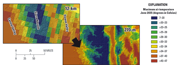
Figure 4. Global Climate Models that project changes in precipitation and air temperature for the 21st century are downscaled to fine spatial scales for application to process-based hydrologic models. Calibration and Uncertainty: What Does This Mean to Your Management Issue?In general, models are calibrated to optimize model output accuracy by minimizing the differences between simulated model outputs and observations. BCM calibrations have been done for basins throughout the western U.S. The BCM calculates unimpaired streamflow and compares it to streamflow in unregulated, upstream tributaries, such as Upper Dry Creek in the Russian River Basin (fig. 5A). Streamflow diversions and estimates of agricultural demand can be included in the calibration for comparison with impaired mainstem streamflow, such as those measured downstream at the Guerneville gage. A final mainstem calibration at a daily timestep is shown for the Russian River at Hopland, California (fig. 5B), which provides confidence in the model extrapolating streamflow into the future. 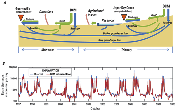
Figure 5. Basin Characterization Model (BCM) model calibration is based on streamflow measurements, shown as an example using A, a schematic of the flow processes in the Russian River basin, including unimpaired and impaired conditions considered in model calibration, and B, final flow calibration for Russian River at Hopland, California. Climate Change Affects Water Availability in Several WaysTiming and AmountThe timing of springtime snowmelt is controlled by air temperature and has been earlier in recent years (fig. 6A). Regardless of the amount of precipitation, less is likely to fall as snow, and snowpack will not maintain the water supply as long into the dry season as at present (fig. 6B). 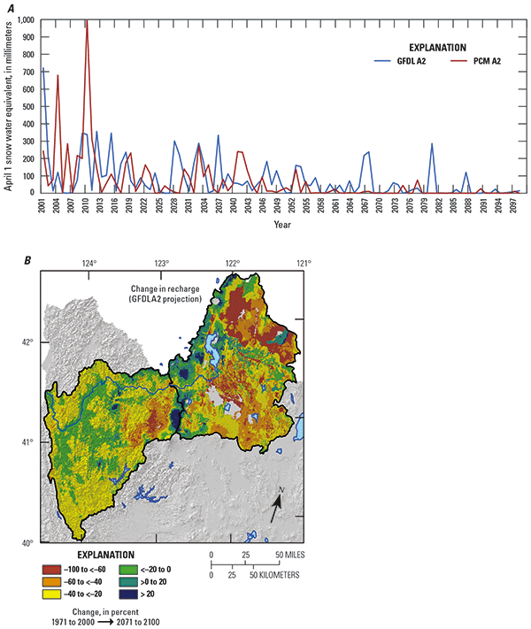
Figure 6. Change in April 1st snow water equivalent projected to the end of the 21st century is shown A, for the Indian Creek basin and B, change in recharge is shown for the entire Klamath River Basin. 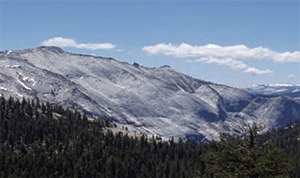 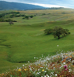
Photo taken by L.E. Flint.
Photo taken by S.B. Weiss.
ExtremesAtmospheric rivers bringing large winter storms, along with extended droughts, create conditions leading to flooding, to declines in water quality, to agricultural effects, and to threats to fisheries. Climate Change and Infrastructure NeedsThe dominant natural hydrologic process that brings water into a watershed influences the kind of infrastructure that has been developed to store and move water to users. With climate change, these natural hydrologic processes can shift, possibly causing a need for new infrastructure or water-supply management changes. These shifts reflect changes in the seasonal timing of precipitation and snowmelt, which, when combined with soil thickness, influence how much water recharges basin groundwater rather than runs off. Loss of snow cover, along with the presence of deep soils, can increase recharge during climate-related compressed wet seasons and the longer dry seasons. In contrast, where there are shallow soils, higher peak flows can increase runoff. For example, the Russian, Tuolumne, Merced, and American River Basins all rely heavily on reservoir storage to maintain the water supply and to sustain it through the dry season. In the American River Basin, there is a projected increase in recharge relative to runoff (fig. 7). The Russian River, Tuolumne, and Merced could be losing recharge. These changes can affect downstream reservoir operations to the extent that efforts to implement groundwater-storage management changes are warranted. 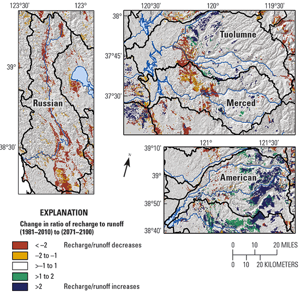
Figure 7. Change in ratio of recharge to runoff for the GFDL A2 projection. Cool colors indicate an increase in recharge relative to runoff; warm colors indicate a decrease in recharge relative to runoff. Effects to Landscapes, Vegetation, and AgricultureClimatic Water Deficit (CWD)The CWD is the annual evaporative demand that exceeds available water. It is calculated as potential evapotranspiration minus actual evapotranspiration and integrates climate, energy loading, drainage, and changes in soil moisture in a single variable (fig. 8A). It is strongly correlated with the distribution of vegetation in a landscape. Because the CWD accumulates the deficit over the season, it is an indicator of the irrigation demand required to make up the seasonal deficit. Interestingly, because the CWD is limited by the capacity of soils to hold extra precipitation that would become runoff or recharge during the wet season, by the end of the summer, it increases with all climate change scenarios, even when wetter years are projected (fig. 8B). 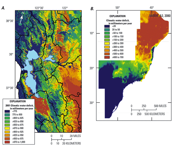
Figure 8. Climatic water deficit (CWD) for A, the San Francisco Bay area watersheds, where the CWD variation is clear as a result of coastal proximity, north and south facing hillslopes, and differing soil depths; and B, the Brazilian Atlantic Forest, which covers much of Brazil, where the CWD, as projected for 2080, varies from north to south. BCM Applications and OpportunitiesThe BCM regional water-balance model (Flint and others, 2013) applies boundary conditions to groundwater-flow models and provides linkages to integrated hydrologic models. It has been applied to local watersheds, regional landscapes, and international projects. Local
Regional
International
Regional water-balance modeling can be used to optimize or prioritize management resources, to assess the spatial distribution of landscape stress or irrigation demand under current or potential future climates, and to evaluate potential changes in species distributions as well as climatic and hydrologic refugia. Summary and ImplicationsThe BCM is a fine-scale hydrologic model that uses detailed maps of soils, geology, topography, and transient monthly or daily maps of potential evapotranspiration, air temperature, and precipitation to generate maps of recharge, runoff, snow pack, actual evapotranspiration, and climatic water deficit. With these comprehensive environmental inputs and experienced scientific analysis, the BCM provides resource managers with important hydrologic and ecologic understanding of a landscape or basin at hillslope to regional scales. The model is calibrated using historical climate and streamflow data over the range of geologic materials specific to an area. Once calibrated, the model is used to translate climate-change data into hydrologic responses for a defined landscape, to provide managers an understanding of potential ecological risks and threats to water supplies and managed hydrologic systems. Although limited to estimates of unimpaired hydrologic conditions, estimates of impaired conditions, such as agricultural demand, diversions, or reservoir outflows can be incorporated into the calibration of the model to expand its utility. Additionally, the model can be linked to other models, such as groundwater-flow models (that is, MODFLOW) or the integrated hydrologic model (MF-FMP), to provide information about subsurface hydrologic processes. The model can be applied at a relatively small scale, but also can be applied to large-scale national and international river basins. Technical ContactsLorraine E. Flint, research hydrologist, lflint@usgs.gov Alan L. Flint, research hydrologist, aflint@usgs.gov James H. Thorne, environmental ecologist, jhthorne@ucdavis.edu Reference CitedFlint, L.E., Flint, A.L., Thorne, J.H., and Boynton, R., 2013, Fine-scale hydrological modeling for climate change applications using watershed calibrations to assess model performance for landscape projections: Ecological Processes v. 2, no. 25, 21 p. Flint, L.E., and Flint, A.L., 2012, Downscaling climate change scenarios for ecologic applications: Ecological Processes, v. 1, no. 2, 15 p. Products from the California BCM can be obtained from Future climate scenarios applied to the California BCM are described at http://ca.water.usgs.gov/projects/reg_hydro/projects/dataset.html |
First posted February 9, 2015 For additional information, contact: Part or all of this report is presented in Portable Document Format (PDF). For best results viewing and printing PDF documents, it is recommended that you download the documents to your computer and open them with Adobe Reader. PDF documents opened from your browser may not display or print as intended. Download the latest version of Adobe Reader, free of charge. More information about viewing, downloading, and printing report files can be found here. |
Flint, L.E., Flint, A.L., and Thorne, J.H., 2015, Climate change: evaluating your local and regional water resources: U.S. Geological Survey Fact Sheet 2014–3098, 6 p., https://dx.doi.org/10.3133/fs20143098.
ISSN 2327-6932 (online)

![]() U.S. Department of the Interior |
U.S. Geological Survey
U.S. Department of the Interior |
U.S. Geological Survey
URL: http://pubsdata.usgs.gov/pubs/fs/2014/3098/index.html
Page Contact Information: GS Pubs Web Contact
Page Last Modified: Tuesday, 29-Nov-2016 17:26:27 EST
