Fact Sheet 2014–3123
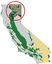
The Cascade Range and Modoc Plateau Study Unit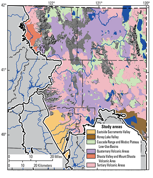
The Cascade Range and Modoc Plateau (CAMP) study unit covers approximately 15,000 square miles in northeastern California. The study unit was divided into six study areas on the basis of geologic features: Eastside Sacramento Valley, Honey Lake Valley, Cascade Range and Modoc Plateau Low-Use Basins, Quaternary Volcanic Areas, Shasta Valley and Mount Shasta Volcanic Area, and Tertiary Volcanic Areas (Shelton and others, 2013; Fram and Shelton, 2015). The volcanic rocks of the CAMP study unit can be highly productive aquifers. Groundwater resides in porous zones between lava flows, fractures that formed during cooling of the lavas, lava tubes, and other features. These systems can be interconnected or isolated, resulting in variability in water levels, well yields, and water quality on local and regional scales. Sedimentary groundwater basins in the CAMP study unit primarily contain Quaternary-age alluvial fan, fluvial, and lake sediments (California Department of Water Resources, 2003). Aquifers composed of different materials can contain groundwater with different chemical compositions. The primary aquifer system of the CAMP study unit is defined as those parts of the aquifer system tapped by wells and springs listed in the State of California’s database of public drinking-water supply sources. In the CAMP study unit, about 10 percent of these sources are springs. Of those that are wells, most are drilled to depths of 140 to 400 feet, consist of solid casing or a seal from the land surface to a depth of about 50 to 220 feet, and are open or have perforated casing below that depth. Water quality in the primary aquifer system can differ from that in the shallower and deeper parts of the aquifer system. Average annual precipitation ranges from 10 to 20 inches over much of the area to over 80 inches at high elevations in Lassen Volcanic National Park and on Mount Shasta. The study unit includes three major hydrologic regions: the Klamath River watershed, the Sacramento River watershed, and closed drainage basins of the North Lahonton area. About 80 percent of the land in the study unit is natural, and much of that land is in national forests. About 16 percent of the land is used for agriculture, and about 4 percent is urbanized. Recharge to CAMP study unit aquifers is mainly from stream-channel infiltration, direct infiltration of precipitation and snow melt, flow through volcanic features, and in some areas, infiltration of irrigation water. Groundwater exits the aquifer system when it is pumped for irrigation or drinking-water supply, discharges into springs, streams and lakes, or evaporates from areas with a shallow depth to groundwater. Overview of Water Quality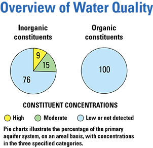
GAMA’s Priority Basin Project evaluates the quality of untreated groundwater. However, for context, concentrations measured in groundwater are compared to benchmarks established for drinking-water quality, such as maximum contaminant levels (MCL). A concentration above a benchmark is defined as high. Benchmarks and definitions of moderate and low concentrations are discussed in the inset box. Many inorganic constituents occur naturally in groundwater. The concentrations of the inorganic constituents can be affected by natural processes as well as by human activities. In the CAMP study unit, one or more inorganic constituents were present at high concentrations in about 9 percent of the primary aquifer system and at moderate concentrations in about 15 percent. Human-made organic constituents are found in products used in the home, business, industry, and agriculture. Organic constituents can enter the environment through normal usage, spills, or improper disposal. In this study unit, organic constituents were not present at high or moderate concentrations in the primary aquifer system. RESULTS: Groundwater Quality in the Cascade Range and Modoc Plateau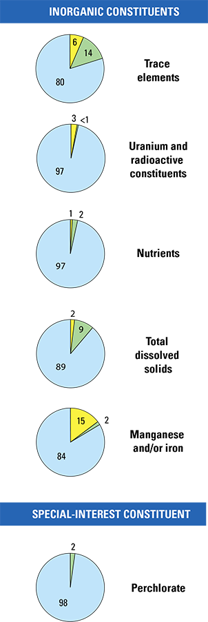
Inorganic Constituents with Human-Health BenchmarksTrace elements are naturally present in the minerals of rocks and sediments and in the water that comes into contact with those materials. In the CAMP study unit, trace elements were detected at high concentrations in about 6 percent of the primary aquifer system and at moderate concentrations in about 14 percent. Arsenic, boron, molybdenum, and vanadium were the trace elements that most frequently occurred at high and moderate concentrations. Radioactivity is the release of energy or energetic particles during spontaneous decay of unstable atoms. Humans are exposed to small amounts of natural radioactivity every day. Most of the radioactivity in groundwater comes from the decay of naturally occurring isotopes of uranium and thorium in minerals in aquifer materials. Radioactive constituents occurred at high levels in about 3 percent of the primary aquifer system and at moderate levels in less than 1 percent. Uranium was the constituent that most frequently occurred at high levels. Nutrients are naturally present at low concentrations in groundwater, and high and moderate concentrations generally occur as a result of human activities. Common sources of nutrients include fertilizer applied to crops and landscaping, seepage from septic systems, and human and animal waste. Nutrients were present at high concentrations in about 1 percent of the primary aquifers and at moderate concentrations in about 2 percent. Nitrate was the only nutrient detected at high concentrations. Inorganic Constituents with Non-Health Benchmarks(Not included in water-quality overview charts shown on the front page) Some constituents affect the aesthetic properties of water, such as taste, color, and odor, or can create nuisance problems, such as staining and scaling. The benchmarks used for these constituents were non-regulatory secondary maximum contaminant level benchmarks. Total dissolved solids (TDS) concentration is a measure of the salinity of the groundwater, and all water naturally contains TDS as a result of the weathering and dissolution of minerals in rocks and sediments. The State of California has a recommended and an upper limit for TDS in drinking water. TDS concentrations were high (greater than the upper limit) in about 2 percent of the primary aquifer system and moderate (between the recommended and upper limits) in about 9 percent. Anoxic conditions in groundwater (low amounts of dissolved oxygen) can result in release of naturally occurring manganese and iron from minerals into groundwater. Manganese or iron was present at high concentrations in about 15 percent of the primary aquifer system and at moderate concentrations in about 2 percent. Special-Interest Constituent: Perchlorate(Not included in water-quality overview charts shown on the front page) Perchlorate is an inorganic constituent that has been regulated in California drinking water since 2007. It is used in solid rocket fuel, fireworks, safety flares, and other products, is present in some fertilizers, and occurs naturally at low concentrations in groundwater. Perchlorate was not detected at high concentrations and was detected at moderate concentrations in about 2 percent of the primary aquifer system. 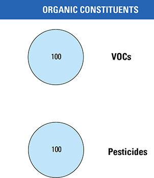
Organic ConstituentsThe Priority Basin Project uses laboratory methods that can detect low concentrations of volatile organic compounds (VOCs) and pesticides, far below human-health benchmarks. VOCs and pesticides detected at these very low concentrations can be used to help trace water from the landscape into the aquifer system. Volatile Organic Compounds with Human-Health BenchmarksVOCs are present in many household, commercial, industrial, and agricultural products and are characterized by their tendency to volatilize (evaporate) into the air. In the CAMP study unit, VOCs were not detected at high or moderate concentrations in the primary aquifer system. Pesticides with Human-Health BenchmarksPesticides, including herbicides, insecticides, and fumigants, are applied to crops, gardens, lawns, around buildings, and along roads to help control unwanted vegetation (weeds), insects, fungi, and other pests. In the CAMP study unit, pesticides were not detected at high or moderate concentrations in the primary aquifer system. BENCHMARKS FOR EVALUATING GROUNDWATER QUALITY
BENCHMARKS FOR EVALUATING GROUNDWATER QUALITYGAMA’s Priority Basin Project uses benchmarks established for drinking water to provide context for evaluating the quality of untreated groundwater. After withdrawal, groundwater may be disinfected, filtered, mixed, and exposed to the atmosphere before being delivered to consumers. Federal and California regulatory benchmarks for protecting human health (Maximum Contaminant Level, MCL) are used when available. Otherwise, nonregulatory benchmarks for protecting aesthetic properties, such as taste and odor (Secondary Maximum Contaminant Level, SMCL), and nonregulatory benchmarks for protecting human health (Notification Level, NL, and Lifetime Health Advisory, HAL) are used. High, moderate, and low concentrations are defined relative to benchmarksConcentrations are considered high if they are greater than a benchmark. For inorganic constituents, concentrations are moderate if they are greater than one-half of a benchmark. For organic and special-interest constituents, concentrations are moderate if they are greater than one-tenth of a benchmark; this lower threshold was used because organic constituents are generally less prevalent and have smaller concentrations relative to benchmarks than inorganic constituents. Low concentrations include non-detections and values less than moderate concentrations. Methods for evaluating water quality are discussed by Fram and Shelton (2015). Benchmark type and value for selected constituents.[Benchmark types: California, State Water Resources Control Board Division of Drinking Water; Federal, U.S. Environmental Protection Agency; HAL, lifetime health advisory; MCL, maximum contaminant level; NL, notification level; SMCL, secondary maximum contaminant level. Abbreviations: ppb, parts per billion or micrograms per liter (μg/L); ppm, parts per million or milligrams per liter (mg/L)]
Factors that Affect Groundwater Quality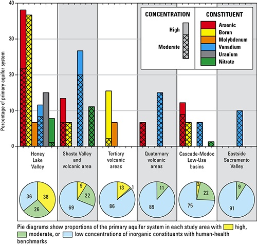
Inorganic constituents with health-based benchmarks were present at high or moderate concentrations in 24 percent of the primary aquifer system of the CAMP study unit; however, the proportions ranged from a low of 9 percent in the Eastside Sacramento Valley study area to a high of 64 percent in the Honey Lake Valley study area. In addition, the individual constituents present at high or moderate concentrations were not the same in the six study areas. These differences in water quality reflect differences among the six study areas in the composition of the rocks and sediments that compose the aquifers, the distribution of developed land uses, the depths of wells, and other factors (Fram and Shelton, 2015). Arsenic, boron, molybdenum, vanadium, uranium, and nitrate were all present at high or moderate concentrations in the Honey Lake Valley study area. Conditions in the Honey Lake Valley study area that contribute to elevated concentrations of trace elements in groundwater include mixing between groundwater and hydrothermal fluids; interaction between groundwater and granitic rocks of the Sierra Nevada, or sediments derived from those granitic rocks; interaction between groundwater and ancient lakebed sediments; and presence of ancient groundwater with low concentrations of dissolved oxygen (Mayo and others, 2010; Fram and Shelton, 2015). Elevated nitrate concentrations are associated with the combination of shallow wells, modern groundwater, and presence of agricultural activity. Priority Basin AssessmentsGAMA’s Priority Basin Project (PBP) assesses water quality in that part of the aquifer system used for drinking water, primarily public supply. Water quality in the primary aquifers may differ from water quality in shallower and deeper parts of the aquifers. GAMA’s Domestic Well Project assesses water quality in the shallower parts of the aquifer system. Ongoing PBP assessments are being conducted in more than 120 basins throughout California. The PBP assessments are based on a comparison of constituent concentrations in untreated groundwater with benchmarks established for the protection of human health and for aesthetic concerns for drinking water. The PBP does not evaluate the quality of drinking water delivered to consumers. The PBP uses two scientific approaches for assessing groundwater quality. The first approach uses a network of wells to statistically assess the status of groundwater quality. The second approach combines water quality, hydrologic, geographic, and other data to help assess the factors that affect water quality. In the SESJ study unit, data were collected by the PBP in 2005–2006 and from the State of California database for 2003–2005. The PBP includes chemical analyses generally not available as part of regulatory compliance monitoring, including measurements at concentrations much lower than human-health benchmarks, and measurement of constituents that can be used to trace the sources and movement of groundwater. SELECTED REFERENCESCalifornia Department of Water Resources, 2003, California’s groundwater: California Department of Water Resources Bulletin 118, 246 p. Fram, M.S., and Shelton, J.L., 2015, Status and understanding of groundwater quality in the Cascade Range and Modoc Plateau study unit, 2010: California GAMA Priority Basin Project: U.S. Geological Survey Scientific Investigations Report 2014-5238, 131 p. https://pubs.usgs.gov/sir/2014/5238/. Mayo, A.L., Henderson, R.M., Tingey, David, and Webber, William, 2010, Chemical evolution of shallow playa groundwater in response to post-pluvial isostatic rebound, Honey Lake Basin, California-Nevada, USA: Hydrogeology Journal, v. 8, p. 725-747. Shelton, J.L., Fram, M.S., and Belitz, K., 2013, Groundwater-quality data in the Cascade Range and Modoc Plateau study unit, 2010: Results from the California GAMA Program: U.S. Geological Survey Data Series 688, 124 p. https://pubs.usgs.gov/ds/688/. |
First posted May 15, 2015 For additional information, contact: Part or all of this report is presented in Portable Document Format (PDF). For best results viewing and printing PDF documents, it is recommended that you download the documents to your computer and open them with Adobe Reader. PDF documents opened from your browser may not display or print as intended. Download the latest version of Adobe Reader, free of charge. More information about viewing, downloading, and printing report files can be found here. |
||||||||||||||||||||||||||||||||||||||||||
Fram, M.S. and Shelton, J.L., 2015, Groundwater Quality in the Cascade Range and Modoc Plateau, California: U.S. Geological Survey Fact Sheet 2014–3123, 4 p., https://dx.doi.org/10.3133/fs20143123.
ISSN 2327-6932 (online)

![]() U.S. Department of the Interior |
U.S. Geological Survey
U.S. Department of the Interior |
U.S. Geological Survey
URL: http://pubsdata.usgs.gov/pubs/fs/2014/3123/index.html
Page Contact Information: GS Pubs Web Contact
Page Last Modified: Tuesday, 29-Nov-2016 17:26:32 EST
