|
|
The U.S. Geological Survey (USGS) has been mapping and studying
California's natural resources and hazards for more than 100 years. In
this time, the State population has grown from less than 1 million to more
than 30 million, which has increased demands on resources and exposed more
people to natural hazards. Many population centers are in areas of natural
hazards. Population growth, combined with development in arid and semiarid
regions of the State, has stressed California's water resources. USGS
information is available to help people understand and deal with natural
hazards and water-supply stresses.
|

|
|
|
|
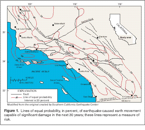
Although most major population centers in California are in seismically
active areas, no earthquake in the past few decades has approached the
maximum anticipated magnitudes. The principal earthquake hazard is the
damage or collapse of buildings or of the infrastructure. The USGS, in
cooperation with the California Department of Conservation's Division of
Mines and Geology (CDMG), the California Institute of Technology, and the
Southern California Earthquake Center is collecting ground-motion data to
produce regional risk-assessment maps that provide estimates of the
probability of significant ground movement (fig. 1). These maps are used
by Federal, State, and local agencies as a basis for building codes and
land-use zoning that can reduce loss of life and property.
(Larger Version, 163K JPEG)
|
|
Figure 1. Lines of equal probability, in percent, of
earthquake-caused earth movement capable of significant damage in the next
30 years; these lines represent a measure of risk.
|
|
In the San Francisco Bay region, USGS scientists are collaborating with the
California Department of Transportation to improve the seismic safety of
six bridges that cross San Francisco and San Pablo Bays. Deep core
sediment samples collected beside the bridge foundations are being analyzed
to determine the capability of the sediment to support the foundations
during earthquake shaking. The USGS study uses geographic information
system computer modeling to evaluate the spatial variation of sediment
properties beneath these bridges. |
|
|
|
Floods are a perennial concern for much of California, and flood
forecasting is an essential part of flood management. The ability to
predict flood frequency and magnitude depends on long-term, continuous
records at many widespread sites. The USGS, in cooperation with Federal,
State, and local water agencies, operates or reviews data for about 1,000
surface-water stations throughout California. Data collected are used by
those water agencies to design measurable, effective, and economically
sound programs and practices for flood protection. Strategically located
streamflow-gaging stations equipped with automatic recording instruments
are connected to computerized flood-warning systems. Water levels,
precipitation, and other data can be accessed by computer from
anywhere. |
|
|
|
|
|
USGS scientists are closely monitoring California's active and potentially
active volcanos. Mount Shasta and Lassen Peak have been active
historically and there are several geologically young volcanic systems,
such as Medicine Lake Volcano in northern California and Long Valley
Caldera on the eastern Sierra Nevada front. USGS scientists are updating
hazards assessments of Lassen Peak, Mount Shasta, and Medicine Lake
Volcanoes. Magma intrusion and seismic activity at Long Valley Caldera
have been closely monitored by the USGS as part of the Volcano Hazards
Program since 1978. Since May 1989, USGS scientists have detected and are
studying the increased emission of carbon dioxide gas of volcanic origin in
the southwestern part of the Caldera. |
The world's largest producing geothermal field, The Geysers near Santa
Rosa, produces sufficient power to meet San Francisco's electrical needs
despite recent reductions in commercial generating capacity. The
geothermal component of the Volcano Hazards Program includes studies at The
Geysers. |
|
|
|
Landslides and mudflows are common in California because of active
mountain-building processes, rock characteristics, earthquakes, and
periodic intense storms. By using earthquake information and geologic data
bases, USGS scientists, in cooperation with the CDMG and the private
sector, have created a computer-generated landslide location map of the Los
Angeles area. They are now working on landslide-hazard maps that show the
slopes most likely to fail in earthquakes. The identification of areas
that are likely to produce landslides in conjunction with earthquakes or
severe storms enables the public, urban planners, and the private sector to
address these conditions as part of any future development. |
|
|
|
|
|
The Sacramento-San Joaquin Delta system (fig. 2) is a vital hydrologic
link in California's water supply, and it has been one of the most
productive estuarine wetland systems on the West Coast. During the past
150 years, the Bay/Delta system has been greatly modified by human
activities. The Delta system is the habitat of two threatened fish species
and several additional species of concern, and the perceived environmental
consequences to them are constraining hydrologic use of the Delta as part
of California's water delivery system.
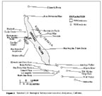
(Larger Version, 65K JPEG)
|
|
Figure 2. Selected U.S. Geological Survey water-resources study
areas, California.
| |
The USGS provides information for two related interagency programs, the
CALFED Bay-Delta Program, which addresses long-term solutions to the
Bay/Delta system's problems, and the Interagency Ecological Program (IEP).
The IEP is a cooperative study by nine agencies that has generated much
knowledge about fish populations in the Bay/Delta system. The USGS
provides to this program an improved understanding of the circulation and
mixing of fresh and saline waters that affect water quality and fish
reproduction and growth.
Additional USGS studies evaluate Delta island subsidence and discharges
that affect drinking water quality in southern California, measure
suspended sediment and contaminant movements and pesticide transport
through the Delta, and investigate wetland functioning and dredge spoil
suitability for wetland restoration. Results of these studies provide a
better understanding of the physical, chemical, and biological factors that
cause ecological and water-quality problems, and are used to reestablish
functional tidal wetlands in the estuary. |
|
|
|
|
|
Wastes generated by human activities have been relocated to the ocean floor
off the California coast. Between 1946 and 1970, as many as 47,800
containers of low-level radioactive waste were dumped on the Continental
Shelf, many west of the Gulf of the Farallons National Marine Sanctuary.
The USGS, in cooperation with several Federal agencies, has developed
computer-enhanced sidescan images useful for locating drums and other
objects. Results of this work can be used by environmental, military, and
fisheries-management agencies to manage waste disposal and to identify
areas critical to fish populations. |
The USGS, in cooperation with Federal and State agencies, has identified
the distribution and character of effluent-affected marine sediment on the
Continental Shelf south of Los Angeles and have modeled its calculated
natural recovery during the next century. This information is used by
Federal, State, and local agencies to develop and evaluate long-term
management options for contaminated sediments. |
|
|
|
The Monterey Bay National Marine Sanctuary, south of San Francisco, is the
largest marine sanctuary in the United States. Its 15,000 square miles are
home to a rich diversity of marine life and include Monterey Canyon, a
submarine feature that rivals the Grand Canyon in topographic relief and
complexity. The USGS, in cooperation with the National Oceanic and
Atmospheric Administration and other Federal and State agencies, is
studying the sanctuary to understand links among living resources, the
physical environment, and human influences. USGS studies include detailed
geologic mapping, and modeling sediment movement across the Continental
Shelf and down the Canyon. The relations among fault lines, fluid seeps,
and carbonate crusts are being discovered and are important to the
distribution of clams on the ocean floor. A detailed understanding of
these geologic processes will assist in the wise management of the
Sanctuary. |
|
|
|
|
|
Historically, water quantity and distribution have been central issues in
California because most water use is in semiarid areas. Because water
quality has recently become a major concern, the USGS, in cooperation with
State and local water agencies, is assessing the quantity and quality of
California's water, especially in the Central Valley, the San Francisco
Bay/Delta system, and the rapidly growing urban areas of southern
California. |
The USGS studies water quality in the San Joaquin-Tulare, the Sacramento,
and the Santa Ana River Basins for the National Water-Quality Assessment
Program. These long-term studies of water quality trends are designed to
provide a sound scientific understanding of the natural and human factors
that affect water quality. They are conducted in cooperation with Federal,
State, and local agencies and other interested parties that participate on
advisory committees and provide historical and current information and
guidance on the priorities for studies and reports. |
|
|
|
|
|
Throughout southern California, local water supplies are limited, and much
of the water is imported from northern California, the Colorado River, and
Owens Valley. Aquifers provide storage for the imported and local water
supplies. Increasingly, water-management agencies are concerned with
making better use of existing and future supplies. The USGS is studying a
comprehensive approach to integrated watershed management, which includes
surface- and ground-water resources. The USGS, in cooperation with the
Water Replenishment District of Southern California, is evaluating the
effects of recharge on ground-water quality in the Los Angeles area. The
results are being used by the District to develop water-quality criteria
for artificial ground-water recharge that uses reclaimed wastewater and to
identify specific characteristics of recharge sites that contribute to
contaminant reduction.
In parts of San Bernardino and Riverside Counties, water-management
agencies anticipate large increases in demand for water early in the next
century. The USGS, in cooperation with these agencies, is engaged in
studies that are designed to characterize hydrogeologic conditions in areas
that appear to have good potential for water banking (recharging
ground-water systems for future pumping) or where ground-water quality may
be subject to degradation from land-use practices or other causes. |
The Mojave Desert region has one of the most rapidly growing populations in
California. As a result, water is becoming more scarce, and ground-water
resources are frequently pumped at rates that far exceed natural recharge.
The USGS, in cooperation with the Mojave Water Agency, is investigating the
surface- and ground-water relations along the Mojave River, which is the
principal source of ground-water recharge. Study results are aiding
water-management agencies in the efficient management of ground-water
resources. |
|
|
|
Intensive ground-water pumping in coastal areas has contributed to aquifer
saltwater intrusion. The USGS is investigating the potential for saltwater
intrusion into coastal aquifers in Ventura and Santa Barbara Counties.
USGS ground-water models are used with water-supply optimization techniques
by State and local agencies to develop management strategies for
controlling saltwater intrusion and accommodating water demands. Water
managers are using the study results to modify recharge, pumping, and
delivery practices. |
|
|
|
The USGS, in cooperation with the CDMG, conducts geologic mapping
activities throughout California for producing and disseminating geologic
information to all levels of government, the private sector, and the
general public. The USGS and the CDMG produce geologic maps at a scale of
1:100,000, thus improving on the statewide coverage at the 1:250,000 scale.
These maps are being produced for areas that are of special interest; for
example, various geologic hazards, specific properties, fault zones, and
mineral resources. In addition, maps are being produced that provide
three-dimensional representations of geologic structures, such as
subsurface connections of parallel faults, or geologic changes, such as
repeated volcanic eruptions. |
|
|
|
A new USGS project is focusing on reducing the environmental impact of
mining through better byproduct recovery. The project goal is to provide
comprehensive data on the existence and nature of useful substances in
ores; the initial study sites are mines in California and Arizona. Better
byproduct recovery will reduce the total volume of mine wastes and
significantly lower their toxicity. This cleaner and cheaper way to mine
can benefit the mineral industry and the environment. |
|
|
|
Elevated mercury concentrations in Cache Creek sediments have been a
problem for many years. The Cache Creek watershed in the Coast Ranges,
which is a tributary to the lower Sacramento River, has numerous
mercury-depositing hot springs and abandoned mercury mines. Until
recently, however, the primary sources and transport mechanisms had not
been well identified. Studies by the USGS, in cooperation with the Central
Valley Regional Water Resources Control Board and the Los Alamos National
Laboratories, have identified hot springs in the Sulphur Creek drainage
basin as a major mercury source. Abandoned mines are a secondary source in
the basin. During most of the year, mercury is deposited primarily in
fine-textured creek sediments within 0.5 mile of the sources, mercury
concentrations can be as high as 195 parts per million (compared with the
average 0.08 to 0.4 part per million for most rock types). During the
first seasonal high streamflow, these sediments are transported down the
drainage basin. This episodic nature of mercury transport is significant
for Cache Creek watershed management and the evaluation of the fate of
mercury originating in the area. |
|
|
|
On October 1, 1996, the National Biological Service joined the USGS as the
Biological Resources Division. The USGS gathers information on threatened
or endangered species throughout California; this information includes the
habitat needs of the Central Valley's giant garter snake, populations of
the California sea otter and western burrowing owl, and salmon runs. The
USGS, in cooperation with the Bureau of Land Management (BLM) and other
land managers, also is studying the rare desert tortoise and the Mojave
Desert. These studies provide technical information to help the recovery
of the desert tortoise and for the better management of the Mojave Desert
ecosystems. Additional studies focus on terrestrial and aquatic
contaminant problems and on wetland restoration efforts in San Francisco
Bay and the Klamath Basin. |
|
|
|
|
|
The BLM is revising the Northern and Eastern Colorado Desert Coordinated
Management Plan for 5.5 million acres in southeastern California. The most
pressing management issue is implementing a recovery plan for the desert
tortoise. Another 30 species of wildlife and plants also are at risk.
Other concerns include biodiversity losses, the impact of decades of
development along highways, expansion of recreation areas, and coordination
among adjacent land-management agencies. |
The USGS has undertaken an assessment that includes studies of the
environmental impact of mined and unmined mineral deposits, studies in
support of mine remediation, and geochemical background and baseline
studies. Hydrology and seismic hazards information also are included.
|
|
|
|
The Sierra Nevada Ecosystem Project is a congressionally mandated
assessment to aid in developing of various policy choices for the future of
the mountain range. The primary goals are a scientific review of mature
forests, watersheds, and significant natural areas and an evaluation of the
entire set of Sierra Nevada ecosystems that includes social, economic, and
environmental components. USGS contributions to the project include
information and expertise on mines, mineral resources, and mineral
environmental issues, potential volcanic activities, and stream flows.
USGS contributions for the final analysis include metal supply
(undiscovered resources) and minerals hazards (acidic mine drainage,
arsenic and mercury contamination in streams, asbestos, dust from open-pit
mines, and cyanide leaks). |
|
|
|
|
|
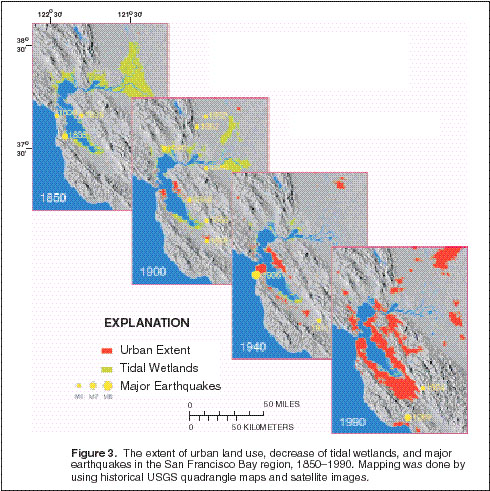
Among the most popular and versatile products of the USGS are its
1:24,000-scale topographic maps that depict natural and cultural features
of the landscape. California is covered by 3,289 maps at this scale. The
USGS is collaborating with California's Teale Data Center to reproduce
these maps for computer use.
Today, scientists and engineers depend on computerized base maps for their
research and analyses. Without the geographic context provided by these
base maps, it would be impossible to understand the spatial patterns of
natural and human activities. The USGS is working to ensure the
availability of accurate digital cartographic data to facilitate studies in
water, hazards, land, and resource management (fig. 3).

(Larger Version, 163K JPEG)
|
|
Figure 3. The extent of urban land use, decrease of tidal wetlands,
and major earthquakes in the San Francisco Bay region, 1850Đ1990. Mapping
was done by using historical USGS quadrangle maps and satellite images.
| |
The National Mapping Program in California has focused on those areas where
data are not yet complete. The USGS has helped a consortium of Federal,
State, and local agencies produce complete coverage of transportation,
hydrography, boundaries, public land surveys, and elevation data for most
of the Klamath and the Trinity River Basins. The USGS also is working with
the U.S. Forest Service to produce digital orthophotoquads of all national
forests in California and, through another program, is completing coverage
of digital elevation data for the Mojave and the Lower Colorado Desert
regions and the rest of southern California.
|
|
|
|
The USGS has an Earth Science Information Center (ESIC) in Menlo Park. In
addition to supplying USGS reports, the ESIC searches data bases for aerial
photographs, historical maps, and digital cartographic data. Topographic
and national park maps for California, as well as other States, are
available for sale over the counter, by mail, or FAX. Other State ESIC
affiliates for USGS products are the CDMG in Sacramento and the Map and
Imagery Laboratory at the University of California-Santa
Barbara. |