This document is also available in pdf format: ![]() fs-005-99.pdf
fs-005-99.pdf
The U.S. Geological Survey (USGS) is mapping the geology of the Ozark Plateaus of northern Arkansas near the Buffalo National River to provide information to the National Park Service (NPS). The highest concern is understanding geologic factors that control paths of ground-water flow in the park area. This information is intended to help identify areas that are likely to introduce sediments, nutrients, and contaminants into the Buffalo River.
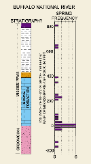
| Figure 1. Relation of spring frequency and stratigraphy. |
Initial studies focused on an area ofknown interbasin transfer of ground water. In this area, water from an agricultural, north-draining, basin flows southward in the subsurface and enters the Buffalo River Basin at large springs. New geologic mapping illustrates that the stratigraphy of rock formations and the faults that cut them influence this interbasin flow. The most springs in the mapped area are found at the base of the cherty limestone of the Boone Formation (fig. 1). Also, newly discovered faults that intersect near the large springs are thought to control the location of discharging waters.
The USGS also is supporting geologic mapping in other parts of the State. The Arkansas Geological Commission (AGC) is mapping parts of southwestern Arkansas, and the University of Arkansas and AGC are mapping parts of northern Arkansas.
Researchers from the USGS, the University of Maryland, the Arkansas Archeological Survey, and the University of Memphis have been studying the record of prehistoric earthquakes at archeological sites in the New Madrid seismic zone. Native American artifacts, charcoal, and other organic materials can be used to date the eruption of sands to the ground surface during earthquakes. Many sites throughout the region are being examined to develop a chronology of large ancient earthquakes and to estimate the probabilities of future earthquakes, a critical aspect of seismic hazard evaluation.
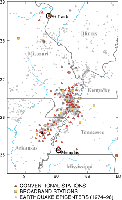
| Figure 2. Stations of the Cooperative New Madrid Seismic Network. Dots in the background are 1974–98 earthquake epicenters. |
The USGS is supporting a cooperative earthquake monitoring network consisting of conventional and broadband stations that can record a broader range of earthquake sizes, within and surrounding the seismic zone (fig. 2). The University of Memphis and Saint Louis University have primary responsibility for network development and operation. This network records ground motions for use in scientific studies and for rapid notification of the public about significant earthquakes.
The USGS also is supporting preparation of soil liquefaction classification maps in the seismic zone. A map of an area that includes parts of northeastern Arkansas recently was completed by the AGC and several other State geology agencies.
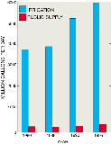
| Figure 3. Irrigation and public-supply water use in Arkansas, 1980–1995. |
Water-use data collected by the USGS, in cooperation with the Arkansas Soil and Water Conservation Commission, indicate that more water is used for irrigation than for any other purpose in Arkansas. Water withdrawals for irrigation in Arkansas in 1995 were estimated to be 5,938 million gallons per day. Of this amount, 83 percent was ground water. Irrigation water use has increased by 61 percent since 1980 (fig. 3). Although the average annual application rate of water decreased about 40 percent between 1980–95, the amount of irrigated land increased. Public supplies in Arkansas served about 2 million people, or 80 percent of the population, in 1995. The population served by public-supply facilities in Arkansas has increased 17 percent since 1980. Meanwhile, total public-supply water use in Arkansas increased by 46 percent.
The Safe Drinking Water Act Amendments of 1996 require each State to prepare a source water-assessment program (SWAP) for all public drinking-water supplies. The assessment aims to determine the potential susceptibility to contamination of the State’s drinking-water supplies. The Arkansas Department of Health (ADH) is the lead State agency to develop the SWAP. The USGS is conducting a 4-year project in cooperation with ADH to provide the tools necessary to complete the SWAP. The USGS will lead the effort and coordinate the assessment work of the Arkansas Water Resources Research Center, the University of Arkansas Department of Geology, and the Center for Advanced Spatial Technologies.
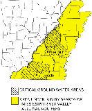
| Figure 4. Critical Ground-Water Areas. |
The Sparta and Mississippi River Valley alluvial aquifers are major water sources for municipal, industrial, and agricultural uses. Recently, the demand for water in some areas has significantly exceeded recharge to the aquifers, and water users and managers have begun to question the ability of the aquifers to supply water for the long term. Based on conditions in these aquifers, the Arkansas Soil and Water Conservation Commission (ASWCC) established two Critical Ground-Water Areas (fig. 4) in 1996 and 1998. This designation mandates maintaining aquifer conditions within specific, water-level based limits.
The USGS and ASWCC developed a regional-scale, computerized groundwater flow model in the mid-1980’s for testing water-use strategies that could affect the Sparta aquifer. Modeling shows that the aquifer cannot supply water for more than 30 years at the current increasing demand. However, model results show that conservation measures and use of alternative sources of water could result in considerable recovery of water levels in the aquifer.
The USGS, in cooperation with the U.S. Army Corps of Engineers, is using a similar model of the alluvial aquifer to evaluate the regional effects of aquifer and alternative water source development on water-level declines. The effects of projected ground-water withdrawals are being simulated through the year 2049. The primary objective is to determine what portion of projected total water demand can be met by the alluvial aquifer while maintaining a certain minimum saturated thickness in the of aquifer material.
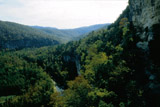
| Figure 5. The Buffalo National River. (Photograph courtesy of A.C. Haralson, Arkansas Department of Parks and Tourism.) |
The USGS and the NPS have developed a partnership to identify water-quality needs in park resource management plans. Beginning in 1999, the USGS will collaborate on three water-quality assessment projects on the Buffalo National River (fig. 5). A planned 3-year study on Bear Creek, a tributary to the Buffalo River, will collect streamflow and water-quality information. Bed-sediment samples will be collected from a tributary of the Buffalo River to determine the extent and occurrence of organic compounds previously detected. To assist in development of a Water Resources Management Plan for the Buffalo National River, the USGS will perform statistical analyses of existing water-quality and streamflow data.
| Figure 6. NAWQA study units in Arkansas. |
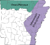
Between 1992–95, ground- and surface-water-quality samples were collected and ecological assessments were performed to describe the regional water-quality conditions of the Ozark Plateaus National Water-Quality Assessment (NAWQA) study unit in Arkansas, Kansas, Missouri, and Oklahoma (fig. 6). Increases in confined-animal populations and human activities pose threats to the quality of water in the sensitive karst environment of the Ozark Plateaus. Nutrients, bacteria, pesticides, trace elements, and fish communities in Ozark Plateaus water have been affected by agricultural, urban, or mining activities.
The Mississippi Embayment NAWQA study (fig. 6) has been collecting water-quality data from two streams and several aquifers in Arkansas. Concentrations of all sampled constituents were found to be well within Federal drinking-water standards. Water-quality data from wells open to the Mississippi River Valley alluvial aquifer are being investigated in 1999.
Forested wetlands constitute the majority of wetlands in the southern United States. As part of the multi-state Southern Forested Wetland Initiative, the USGS has wetland forest study sites in Arkansas and is working with managers at several National Wildlife Refuges. The USGS provides broad expertise in monitoring the success of forested wetland restoration, improving wildlife habitat-management techniques, and studying the genetic diversity of bottomland hardwoods. Scientists also are studying bird populations whose reduced numbers have paralleled the tremendous loss of southern forested wetlands.
As part of the Arkansas Cooperative Fish and Wildlife Research Unit in Fayetteville, the USGS has worked with the Arkansas Game and Fish Commission and the National Wild Turkey Federation to determine the causes of decline in a wild turkey population in the Ouachita Mountains. Researchers estimated the reproductive success of turkey hens by radiotagging and tracking individuals from 1993 to 1996. The studies found that low nesting success, low nesting attempts, and small clutch size were typical of this population. Predator density may interact with weather and hen condition to influence success and may alter nest site selection. Disease did not appear to be a substantial population-limiting factor. The findings and relations identified in this research are intended to assist agencies in developing appropriate management strategies.
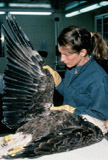
| Figure 7. A biologist examining a dead bald eagle. |
At least 56 bald eagles and an unknown number of American coots have died in south-central Arkansas. The USGS is working with the Arkansas Game and Fish Commission and other Federal, State, and private laboratories to identify the cause of these mysterious deaths (fig. 7). USGS scientists have identified an unusual microscopic lesion in the white matter of the eagle and coot brains. The cause of the lesions remains unknown, but scientists suspect that the lesions are related to a toxic agent. The USGS is continuing field investigations and diagnostic efforts to identify the source of the problem.
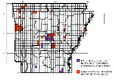
| Figure 8. Topographic map revision plan, February 3, 1999. |
Revision The USGS has developed a strategy to help identify the 7.5-minute topographic maps that are in demand and that need to be revised (fig. 8). This plan uses monthly map sales as one criterion for determining demand, and then prioritizes the map in the revision process. Also, the AGC selects maps to be revised under a cooperative program with the USGS.
|
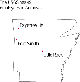
The USGS office locations
|
USGS State Representative USGS Home Page: Reports and products: |
| Fact
Sheet Theme Page |
Environment | Hazards | Information
Management |
Resources | State |
U.S. Department of the Interior, U.S. Geological Survey