|
The safety, health, and economic well-being of citizens in Florida are
important to the U.S. Geological Survey (USGS), which is involved in
water-related, geologic, biological, land use, and mapping issues in many
parts of the State. The Florida District Office in Tallahassee acts as the
liaison for all studies conducted by USGS scientists in Florida.
Water-resources activities are conducted from the District Office and
Subdistrict Offices in Miami, Tampa, and Altamonte Springs (Orlando).
Scientists in these offices investigate surface and ground water and water
quality, working in cooperation with other Federal, State and local
agencies and organizations. |
The USGS Center for Coastal Geology and Regional Marine Studies was
established in St. Petersburg in 1988 in cooperation with the University
of South Florida. The Center conducts a wide variety of research on
mineral resources and on coastal and regional marine problems, which
include coastal erosion, climate change, wetlands deterioration, and
coastal pollution. This research is leading to more accurate predictions
of future coastal erosion, the evolution of wetlands, the fate of
contaminated sediments, and the location of economically valuable sand and
gravel and minerals.
An Earth Science Information Center (ESIC) was established in Tallahassee
in 1985 under a cooperative agreement with the Florida Resources and
Environmental Analysis Center of Florida State University. As part of the
National ESIC network, this office provides information and directs
inquiries to the USGS or the appropriate State agency on such earth science
topics as cartography, geography, digital data, remote sensing, geology,
geophysics, geochemistry, hydrology, geohydrology, aerial photography, and
land use in Florida. It is supported by the USGS with reference materials,
technical assistance, outreach activities, and data base access. |

Widespread population growth and land-use modification in Florida threaten
the quantity and quality of drinking water, alter natural wetlands, and
increase human exposure to geologic hazards, such as flooding, sinkholes,
and erosion. Major problems with water quantity and quality can result
from saltwater intrusion, aquifer dewatering, ditch excavation, water
withdrawal, domestic and industrial solid and liquid wastes, atmospheric
deposition, contaminated soils and sediments, and varying lengths of wet
and dry periods. Other hazards, such as sinkhole development, radon,
coastal erosion, and hurricane effects are additional environmental
concerns. These concerns are being addressed by several USGS programs that
are being conducted in cooperation with other Federal, State, and local
agencies. |
|
|
|
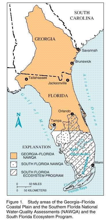
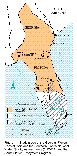
In 1991, the USGS began a full-scale National Water-Quality Assessment
(NAWQA) Program to improve the understanding of environmental stresses to
the Nation's water supply by using a regional approach. Two NAWQA studies
cover most of peninsular Florida (fig. 1).
These studies provide a basis for evaluating the effectiveness of
water-quality management programs and predicting the likely effects of
changes in land- and water-management practices. A third, which is mostly
in Georgia, includes the Appalachicola River Basin in the western panhandle
of Florida.
|
(Click on image for a larger version, 41K JPEG)
|
|
Figure 1. Study areas of the Georgia-Florida Coastal
Plain and the Southern Florida National Water-Quality Assessments (NAWQA)
and the South Florida Ecosystem Program. | |
|
South Florida |
|
The South Florida NAWQA Program study, which began in 1993, encompasses a
large regional ecosystem (fig. 1) that
covers about 19,500 square miles. The study area, which includes the
Kissimmee-Okeechobee-Everglades Basin, is characterized by dense urban
development near the coast, intensive agricultural development in the
northern Everglades, Native American lands in the interior, and vast
regions of rangeland and wetlands throughout. The southern part of the
study area is mostly under public control as parks, preserves, sanctuaries,
conservation areas, and refuges; it contains most of the remaining
Everglades and adjacent South Florida wetlands.
The South Florida study addresses unique environmental issues by using a
multiscale, interdisciplinary approach. The study design includes analysis
of historical data, surface- and ground-water assessments, and ecological
studies. Streambed sediment and tissue studies are ongoing. Largemouth
bass, or Florida gar, have been collected at 15 sites to assess organic and
trace-metal contamination. A surface-water-quality sampling program at 7
sites within the study area and a ground-water sampling program of 30
shallow wells completed in the Biscayne aquifer and which are within a
residential area in southeast Florida have been initiated.
|
Agricultural, industrial, and urban areas are sources of water-quality
degradation. Agricultural production uses numerous chemicals, which
include fertilizers, insecticides, herbicides, and fungicides, that can
leak into ground water or nearby surface waters. Water drained into canals
from farms and cattle lands contains high concentrations of nutrients and
numerous chemicals that enter Lake Okeechobee and the Everglades.
Nutrients in water are necessary for productive aquatic ecosystems, but in
high concentrations they can adversely affect aquatic life and human
health. The Everglades is the largest continuous area in Florida from
which fish are banned for consumption because of mercury contamination, the
source of which is still under investigation. Altered water quality and
high concentrations of nutrients also may be impacting coastal waters such
as Florida Bay, where large areas of seagrasses have died, algal blooms
have increased, and fisheries have declined over the past 10 years.
The Biscayne aquifer is the principal source of potable water for
southeastern Florida and has been designated as a "sole-source" drinking
water supply by the U.S. Environmental Protection Agency (USEPA). However,
the permeable Biscayne aquifer is at or near land surface, which could
increase the potential for contamination from surface sources in this
highly urban area. |
|
Georgia-Florida Coastal Plain |
|
The Georgia-Florida Coastal Plain NAWQA Program study area covers nearly
62,000 square miles and is divided almost equally between the States of
Georgia and Florida (fig. 1). Seven
hydrologic subregions are located within the study area, which includes the
Altamaha and the Suwannee Rivers. The Floridan aquifer system is the major
ground-water system.
The Georgia-Florida Coastal Plain study area is populated by 9.3 million
people who rely primarily on the Upper Floridan aquifer for drinking water.
More than 5 billion gallons of freshwater are used daily; more than 90
percent of the public supply is derived from the Upper Floridan aquifer.
Nutrient data, which have been collected over the past 20 years by the
Florida Department of Environmental Protection's (FDEP) Ambient Ground
Water Monitoring Program, the USGS, and the Georgia Geologic Survey, were
evaluated early in the study. In September 1995, the 3-year phase of
intensive data collection was completed. During that phase, more than 800
samples were collected and analyzed for pesticides, nutrients, and major
water-quality constituents.
|
Preliminary analyses of surface-water samples show very low values of 25
pesticides that have been detected in urban and agricultural basins.
Concentrations of pesticides display seasonal variations that generally
follow usage patterns. Among the intensively studied sites, more
insecticides occurred in an urban basin than in two agricultural basins.
In the Suwannee River Basin, preliminary analysis of streambed sediment
samples and tissue samples collected from clams has identified the presence
of elevated mercury and arsenic concentrations.
Ground-water samples collected from a predominantly agricultural
eight-county area in Georgia showed elevated concentrations of nitrate; 7
of the 23 samples collected showed concentrations above the
10-milligram-per-liter USEPA drinking-water standard. Elevated nitrate
concentrations in agricultural areas in Florida also have been observed,
but statistics are not yet available. |
|
The USGS is conducting a number of ecosystem studies to provide scientific
data to Federal and State management and regulatory agencies for the
maintenance and restoration of the South Florida ecosystem. A major
multidisciplinary effort is currently directed toward South Florida.
|
|
|
|
The South Florida ecosystem, which
includes the Everglades, has been dramatically altered during the past
century by human activities. It is assumed that restoration of the South Florida ecosystem will follow
restoration of natural hydrologic conditions, although this assumption is
difficult or impossible to prove. Competing demands for water for
household use, agriculture, fisheries, and ecosystem protection and
restoration, as well as the construction of numerous canal systems,
complicate the issues in South Florida and Florida Bay. The USGS has
initiated the South Florida Ecosystem
Program to provide scientific insight on the hydrology, geology, and
ecology, which are inextricably linked in the Everglades and Florida Bay
and along the South Florida coast (fig. 1).
The Program complements ongoing and planned USGS activities such as the
NAWQA Program, cooperative water-resources studies, the geologic and
topographic mapping programs, and the work of the Center for Coastal
Geology.
The Program focuses on developing key scientific information on hydrologic
conditions to assist Federal, State, and local resource-management agencies
and the private sector in their restoration efforts. Ongoing work includes
the following:
- Measurement of the quantity of water discharging from the ecosystem to
coastal waters and measurement and modeling of the movement of water
through the various internal components of the ecosystem to assess the
availability of water for competing requirements
- Identification of the processes that transform and transport nutrients and
mercury through the ecosystem to assess water quality within South Florida,
Florida Bay, and the Keys and fringing reefs and to provide the data needed
by responsible agencies to design remediation facilities
|
- Reconstruction of freshwater and saltwater distribution, the frequency of
fires, and the accumulation rates of nutrients and trace metals over the
past 150 years, to determine the ecosystem history and the natural
hydrologic conditions of South Florida and Florida Bay
- Preparation of bimonthly salinity maps of Florida Bay
- Description of the sediment dynamics of Florida Bay; these include
interpretation of turbidity from satellite images
- Production of topographic maps and the related data needed to support
scientific investigations and the design of ecosystem restoration
alternatives.
One of the Program's first products is a satellite image map of South
Florida that was based on 1992 and 1993 Landsat thematic mapper images.
Satellite imagery shows subtle land elevation changes in the flat terrain
of the Everglades, which do not appear on standard topographic maps. The
satellite image map provides recent information on distribution of
vegetation types and other land-cover features and serves as a baseline
from which to plan restoration efforts in South Florida.
The Program is a collaborative effort by the USGS with a large number of
other Federal and State agencies. Coordination is being conducted through
USGS participation in the working group and subgroups of the South Florida
Ecosystem Restoration Task Force, which includes 12 Federal agencies, 6
State agencies, and the Miccosukee and the Seminole Indian Tribes. |
|
Biological Studies |
|
The USGS Biological Resources Division (formerly the National Biological
Service) conducts research in Florida, Puerto Rico, and the Virgin Islands
from its Florida Caribbean Science Center (FCSC) in Gainesville. The
FCSC's research includes studies of the endangered Florida manatee by means
of its Sirenia Project, life-history studies of the threatened Gulf
sturgeon and impacts of nonindigenous species on native ecosystems, studies
on the threatened Kemp's Ridley sea turtles, studies related to restoration
of the South Florida ecosystem,
and helping the J.N. Ding Darling National Wildlife Refuge identify the
cause of recent aquatic fauna die-offs.
The National Wetlands Research Center in Lafayette, Louisiana, documents
the ecological effects of hurricanes, fire, and hydrological changes in Big
Cypress National Preserve and Everglades National Park. Its Gulf Breeze
office develops digital data bases on water quality and contaminants in
Gulf of Mexico estuaries. The Center also helps assess potential impacts
of Outer Continental Shelf oil and gas development and identifies the
effects of increasing temperature, sea level, and atmospheric carbon
dioxide on wetland plants in St. Marks National Wildlife Refuge.
|
The Florida Cooperative Fish and Wildlife Research Unit in Gainesville
works with the University of Florida to conduct research on invasive
plants, threatened and endangered species, fish community dynamics, and
landscape ecology issues. |
|
|
|
The USGS, in cooperation with Florida resource-management agencies, is
studying major hydrologic issues, which include flood-plain ecosystem water
needs, integrated ground- and surface-water management, water-supply
availability, surface and subsurface ground-water recharge with treated
wastewaters, development of brackish ground-water resources,
evapotranspiration/natural ground-water recharge relations, interaction of
lakes and wetlands with ground water, and increased water withdrawal to
supply users' needs. Programs are reviewed regularly and future needs for
data collection and hydrologic investigations are developed jointly with
cooperating State and local agencies. Typically, USGS investigations are
of the following major types: data collection, problem-oriented appraisals,
applied research, and hydrologic system definition.
The historical and current data-collection programs in Florida consist of
monitoring networks for streamflow, ground-water levels, and surface- and
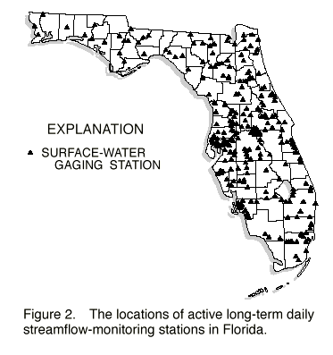
ground-water quality. One unique surveillance program is the USGS's
streamflow program, which is the primary source of long-term discharge data
in the State (fig. 2). Information from
various USGS networks is combined for all the States to establish a
national computerized data base.

(Larger Version, 264K GIF)
|
|
Figure 2. The locations of active long-term daily
streamflow-monitoring stations in Florida. |
|
In 1995, the USGS conducted about 50 hydrologic studies, most of which can
be categorized as problem-oriented appraisals and applied research. These
include, by broad categories, 21 studies to determine the availability of
regional water resources for population growth management planning, 17
studies for assessment of water-quality degradation, and 13 research
studies on such topics as loss of water to the atmosphere by evaporation
and plants, hydrodynamics and chemical modeling of ground- and
surface-water flow, and wetland processes--all of which are important to
water-resources management.
These studies were done cooperatively with the five Florida Water
Management Districts, the Florida Department of Environmental Protection
(FDEP), the Florida Department of Transportation, and a number of county
and local agencies. |
|
|
|
The west-central coast of the Florida peninsula is characterized by sandy
barrier islands with numerous inlets and a low wave and tidal energy
regime. Despite the low average energy, this coast is highly dynamic,
changeable, and subject to erosion. In fact, the FDEP has classified about
60 percent of the beaches along the west-central Florida coast as "critical
erosion areas." Many have required beach replenishment that has cost tens
of millions of dollars. The USGS, in cooperation with researchers from the
University of South Florida and Eckerd College, initiated a 5-year program
in October 1994 to study these problems. Results of the study are intended
to provide information for long-term management and protection of the
barrier island and inlet system. The research is divided into studies of
the geologic framework of the coast, the oceanographic processes related to
sea-level change and coastal sediment transport, and the changes in size,
shape, and position of barrier islands and sand bodies on the inner shelf.
|
By using high-resolution seismic profiling, side-scan sonar surveying, and
surficial sediment samples and sediment cores, the USGS and its
collaborators are mapping the distribution of sediment on the inner shelf
in an attempt to understand the relation between the sediment on the
beaches and in adjacent shallow waters offshore. Side-scan sonar mosaics
reveal a complex pattern of bottom characteristics and suggest an irregular
distribution of sediments. Maps of beach-quality sand north of Tampa Bay
have been produced for the U.S. Army Corps of Engineers to help identify
potential borrow sites for beach replenishment projects. |
|
|
|
The statemap component of the National Cooperative Geologic Mapping Program
is a funding vehicle whereby the USGS coordinates a 50:50 (Federal:State)
dollar match that, through a competitive proposal process, supports mapping
projects by individual State geological surveys. The geologic mapping
project products are designed to help resolve issues of ground-water
protection, waste-disposal siting, metallic and (or) nonmetallic
mineral-resource identification, and land-use planning.
|
Current projects in Florida involve mapping of near-surface geology in the
southern Everglades to assist with future planning decisions regarding the
flow and interactions of ground and surface waters. |
|
|
|
Among the most popular and versatile products of the USGS are its
1:24,000-scale topographic maps (1 inch on the map represents 2,000 feet on
the ground). These maps depict basic natural and cultural features of the
landscape, such as lakes and streams, highways and railroads, boundaries,
and geographic names; contour lines are used to depict the elevation and
shape of terrain. Florida is covered by 1,041 maps at this scale, which
are useful for a multitude of technical and recreational applications.
Statewide digital line graph coverages of Public Land Surveys, boundaries,
hydrography, and transportation have been prepared under a joint agreement
with the FDEP and are available for computer applications. Digitized
contour data are available for about one-quarter of the State, and digital
elevation models are available for about one-half of the State. In 1996,
the USGS and the State of Florida initiated a statewide digital revision
program that begins in the panhandle and works eastward.
|
A statewide coverage of digital orthophotoquads (DOQ's) is the result of
agreements with the FDEP, several Water Management Districts, and the
National Park Service (NPS). DOQ's are derived from digitized aerial
photographs that are corrected for displacement caused by camera tilt and
terrain relief. They are becoming increasingly popular as a geographic
information systems component, where they are used in combination with
vector data. In cooperation with the NPS, the FDEP, St. John's Water
Management District and the South Florida Water Management District, the
USGS is producing digital raster graphics (DRG's) for the State. A DRG is
a scanned image of a topographic map that retains the positional accuracy
of the map in raster format. Recently acquired DOQ images can overlay
DRG's to provide new information for revising base maps.
Through its Earth Resources Observation System Data Center near Sioux
Falls, South Dakota, the USGS distributes a variety of aerial photographs
and satellite image data products that cover the entire State of Florida.
Satellite images, which date from 1972, can be used to study changes in
regional landscapes. |
|
|
|
The destructive forces of hurricanes cause loss of life and property,
particularly in coastal areas. USGS scientists currently are developing a
new method of forecasting the size and number of national disasters and
their attendant losses. The magnitude of future hurricanes is being
forecast in terms of fatalities and dollars, as well as by traditional
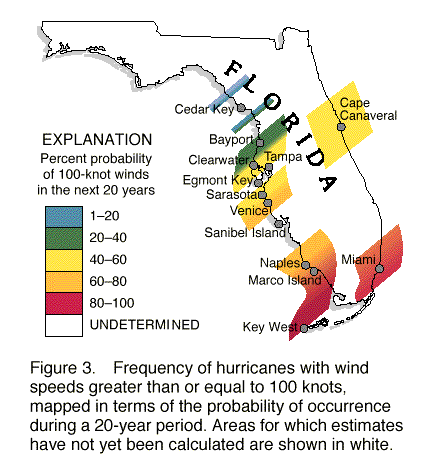
scientific characteristics. Probabilistic estimates of hurricanes in
Florida, which were based upon 106 years of observations, indicate that
hurricanes with winds equal to or greater than 100 knots occur more
frequently in South Florida and gradually decrease toward northern Florida
(fig. 3).

(Larger Version, 264K GIF)
|
|
Figure 3. Frequency of hurricanes with wind speeds greater
than or equal to 100 knots, mapped terms of the probability of occurrence
during a 20-year period. Areas for which estimates have not yet been
calculated are shown in white. |
|
Other USGS hurricane-related studies include storm-surge measurements and
damage assessment. On October 4, 1995, Hurricane Opal came ashore in the
Florida panhandle and caused major coastal damage to a 100-mile stretch of
beachfront. This was the second most damaging storm in Florida's history
after Hurricane Andrew. In a cooperative effort between the USACE (Mobile,
Alabama office) and the USGS (Tallahassee office), storm surges of from 12
to 15 feet above sea level were measured. Although winds reached 117 knots
(135 miles per hour), aerial photographs and videos taken by the USGS
indicate that most damage was due to surge, rather than to wind. |
|
|
|
The Big Bend region of Florida includes more than 120,000 acres of
undisturbed coastal wetlands (20 percent of all estuarine wetlands along
the U.S. coastline facing the Gulf of Mexico). The region includes coastal
counties north of Tampa from Pasco to Wakulla Counties, where the
population has increased 250 percent in the last 20 years. These wetlands
are very sensitive to environmental stresses. For example, sabal palms in
these wetlands have been dying, and recent freezes have killed mangroves in
the area, which has caused significant alterations of environments. The
USGS, in cooperation with the Florida Geological Survey, the University of
South Florida, and the University of Florida, is conducting a 5-year study
to document the changes of wetlands in this region and to identify the
factors that are contributing to losses in wetland area. These cooperative
efforts are leading to an understanding and potential prediction of the
response of wetlands to sea-level fluctuations and the migration of marshes
into upland areas. Wetland areas that have experienced critical change are
being identified. Results help in the management of public lands, such as
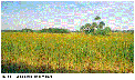
national wildlife refuges and State parks (fig.4).
|
(Larger Version, 264K GIF)
|
|
Figure 4. Typical South Florida Wetland. |
|