This document is also
available in pdf format: ![]() fs-012-99.pdf
fs-012-99.pdf
The long-lived eruption of Kilauea Volcano on the island of Hawaii, now in its seventeenth year, ranks as the most voluminous outpouring of lava on the volcano's east rift zone in the last two centuries, and the most destructive eruption. Since the eruption's onset on January 3, 1983, lava flows have added 570 acres of new land to Hawaii and paved over 40 square miles that included rare rainforest, treasured historical sites, and several communities.
The character of the eruption changed in 1986 from intermittent to continuous. The large amounts of noxious sulfur dioxide gas released from the erupting vents have created volcanic air pollution, known locally as vog (volcanic smog), and acid rain over extensive areas downwind. To improve understanding and to evaluate the hazards of vog, scientists from the Hawaiian Volcano Observatory (HVO) closely monitor the amount and composition of gas emissions from Kilauea. On average, about 2,000 tons of sulfur dioxide gas are released each day into the atmosphere from Kilauea's erupting vent.
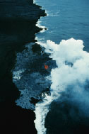
image size 56KB |
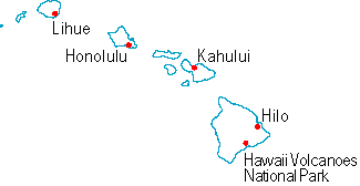
| Figure 1. A bench of shiny hot lava flow builds Kilauea beyond the old coastline in 1994. Lava spatters from the roof of an active lava tube, which carries lava from the vent area 7 miles away. |
During the period of eruption, 28 earthquakes with a magnitude of 5 or greater have shaken Hawaii, eight on Kilauea alone. Some of these earthquakes have damaged houses and other buildings and roads. The strong earthquakes are related to structural adjustments and faulting within Mauna Loa and Kilauea Volcanoes. Thousands of smaller earthquakes also occurred on Kilauea, the direct result of underground movement of magma, but most were too small to be felt or to cause damage. Large earthquakes probably are the single largest natural hazard on the island of Hawaii. Events such as the magnitude 7.2 earthquake in 1975 and the magnitude 7.9 earthquake in 1868 are expected outcomes of the general instability of the island. The USGS maintains the HVO to study volcanic and earthquake activity in Hawaii and to consult with emergency-response officials as they endeavor to protect people and property. During eruptions, the HVO provides information on lava movement that helps guide decisions by Hawaii County Civil Defense and Hawaii Volcanoes National Park regarding evacuation, road closures, and vantage points for visitors. When lava nears inhabited areas, scientists work around the clock to provide up-to-date assessments of the eruption's status and lava-flow locations.
In the past year HVO scientists have launched an aggressive campaign to upgrade and expand the volcano- and earthquake-monitoring networks for the active volcanoes on Hawaii and at Haleakala on Maui, the only other island with an active volcano. New instruments placed on Mauna Loa Volcano will improve the capability to detect early warning signs of its next eruption and to approximate the vent location before the eruption starts. Mauna Loa poses a greater hazard than the more active Kilauea, because of its huge eruptions and steep slopes.
Detailed geologic mapping of Hawaii's active volcanoes continues to uncover important information about past eruptions. This knowledge is vital for preparing hazard assessments and for preparing the publicfor the next eruption. In particular, the increased use of geographic information system techniques for mapping lava flows on Mauna Loa will yield improved probabilistic hazard assessments.
A troubling recent discovery is that Kilauea has erupted explosively many times in the past 5,000 years, most recently in 1924 and, with major loss of life, in 1790. This discovery results from geologic mapping and analysis, which have found and dated several beds of explosive debris previously unknown or poorly known.
A critical issue in the Hawaiian islands is a reliable supply of freshwater. Although rainfall, streamflow, and ground water generally are abundant in Hawaii, most islands are withdrawing water at rates close to the estimated yield of aquifers near the populated areas. In addition, most proposed urban development is in the dry, leeward areas of the islands.
The USGS, in cooperation with State and local agencies, is conducting studies to quantify the availability of ground water in five of the six major islands of Hawaii. As part of these studies, the USGS has undertaken an exploratory drilling program on Hawaii, Oahu, and Kauai.
Studies and test drilling that have led to the discovery and quantification of developable ground-water resources have been completed in the North Kohala and Kona areas of the island of Hawaii, north-central Oahu, and southeastern Kauai. Similar studies are underway for western Maui, and northeastern Kauai.
 images size 56KB |
| Figure 2. Anianiau (Hemignathus parvus) from the Alakai Wilderness Preserve, Kauai. This species is currently restricted to high elevation montane rain forests on Kauai. Like other native honeycreepers, Anianiau are highly susceptible to avian pox and malaria, and they have disappeared from former low elevation habitats because of mosquito-transmitted avian diseases. |
The introduction to Hawaii of avian pox and avian malaria, along with the Culex mosquitoes, which spread these diseases, has had a severe impact on native forest bird communities. Scientists at the USGS Pacific Islands Ecosystems Research Center have taken a leading role in evaluating the effects of these diseases on highly susceptible Hawaiian honeycreepers, a unique and diverse group of native birds.
USGS researchers have developed new diagnostic tools for detecting the diseases, conducted surveys to estimate the extent of disease and mosquito distribution, and tested habitat management strategies for controlling mosquito populations. Ongoing investigations focus on achieving a better understanding of disease and mosquito ecology, and on the natural evolution of disease resistance in some honeycreeper species.
The Olaa-Kilauea Project is a multiagency cooperative partnership to develop and implement management programs to control alien species, restore rare populations of plants where necessary, and ensure the survival of endangered plants, animals, and insects. This partnership offers an unparalleled opportunity to preserve large, functioning native ecosystems, and it serves as a model for future protection efforts throughout the Hawaiian archipelago. The 32,000-acre section of land on the windward western slope of Mauna Loa Volcano on the island of Hawaii represents a significant contiguous block of some of the most intact native montane wet and moist forest on the island. The cooperators and landowners in this endeavor are the Kamehameha Schools-Bishop Estate, the Hawaii Department of Public Safety, the U.S. Fish and Wildlife Service Pacific Islands Program-Ecosystem Region Office, the Department of Land and Natural Resources, the U.S. Forest Service, the Hawaii Volcanoes National Park, and the USGS. Vocational training is a unique feature of this partnership.
 images size 45KB |
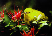
| Figure 3. Feral pigs pose a major threat to the native forests and endemic species within the Olaa-Kilauea Management Area. About 10,000 acres have already been enclosed with pig-free fencing and are showing significant signs of recovery. |
To address the need for consistent and scientifically sound information for managing the Nation's water resources, the USGS began a full-scale National Water-Quality Assessment (NAWQA) Program in 1991. The NAWQA program is unique compared with other national water-quality assessment studies in that it integrates the monitoring of the quality of surface and ground waters with the study of aquatic ecosystems. The island of Oahu is one of several NAWQA studies that began in Federal fiscal year 1997.
The goals of the this program are to (1) describe current water-quality conditions for freshwater streams and aquifers, (2) describe how water quality is changing over time, and (3) improve our understanding of the primary natural and human factors affecting water quality. The Program also seeks to provide some of the information needed by water-resource managers to implement effective water-quality management actions and evaluate long-term changes in water quality.
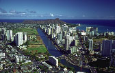 image size 78KB |
| Figure 4. In the urban area of Honolulu, runoff affects several streams, the Ala Wai Canal estuary, and nearshore water of the major tourism center of Waikiki. (Photo by Douglas Peebles.) |
Ground water provides essentially all municipal and domestic water for a large and expanding population on Oahu. The streams provide important riparian and instream habitats for many threatened and endangered species. In addition, streams affect the physical, chemical, and aesthetic quality of receiving estuaries, bays, and nearshore waters, which are critical to the tourism-based economy of the island. The Oahu NAWQA study will examine the relationships among natural factors, human activities, and water-quality conditions.
Major water-quality issues on Oahu are: (1) water-use and water-quality changes expected as a result of land-use changes from large-scale sugarcane plantations to urban and small-scale diversified agriculture, (2) the potential for further water-quality degradation of the principal drinking-water supply aquifer in central Oahu, (3) the potential loss of native aquatic communities by degradation of riparian and instream water quality and habitat, and (4) sediment and chemical loading in streams and delivery to estuaries, bays, and nearshore waters.
Among the most popular and versatile products of the USGS are its 1:24,000-scale topographic maps. These maps show natural and cultural features of the landscape, such as lakes and streams, highways and railroads, boundaries, and geographic names. The State of Hawaii is covered by 127 maps at this scale.
Through inspection of recent aerial imagery, it was found that 66 of the State's topographic maps needed to be updated. The National Imagery and Mapping Agency and the USGS are cooperatively funding the revision of these maps. In an effort to convert all national data to the more accurate North American Datum of 1983 (NAD83), all maps being revised will be reprojected from the Old Hawaiian Datum to NAD83. To provide a consistent map coverage for the State, the remaining 61 maps that do not need revision will be reprojected to the new datum through cooperative partnerships.
Many different sources of information are required to update the variety of map features. The USGS recognizes that in many areas the best geographic data are produced by local agencies. The City and County of Honolulu was the best source for street and park boundary data for the island of Oahu. A data-exchange agreement between the two agencies allowed the USGS to use city and county large-scale data to update the maps. This cooperation helps the USGS avoid duplicating the local mapping effort so that more can be done at lower cost, and provides the public with a smaller-scale version of the best source of street and parks data for Oahu. Furthermore, the data exchange agreement establishes a mechanism for future cooperation between the USGS and the City and County of Honolulu.
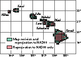 image size 9KB |
| Figure 5. Hawaii topographic map revision and reprojection projects. |
Along with topographic maps, digital line graph (DLG) files and digital raster graphics (DRGs) also are being revised, reprojected, or both. The DLG data are digital representations of cartographic features found on topographic maps. A DRG is a scanned, georeferenced image of a topographic map. Both products are useful for a variety of computer mapping functions such as a backdrop for orienting users or for combining with other digital data.
The map revision effort is intended to provide more up-to-date maps and digital data where they are needed. All maps and data are accessible to the broad range of scientific, government, military, and private agencies and individuals interested in the State.
Coastal erosion is widespread and locally severe in Hawaii and other low latitude areas. For example, about 25 percent of the sand beaches on Oahu have been lost or severely degraded during the last 60 years. To understand the shoreline's history and plan for future use, USGS coastal scientists are documenting the coastal-erosion history of Hawaii. They will determine the causal factors of erosion, provide high-quality data for other "end-users" in applied studies (such as coastal engineers, planners, and managers), and increase the general understanding of low-latitude coastal geologic development. The research approach is to quantify the magnitude and locations of serious erosion problems, and then monitor coastal change in critical areas. Selected field sites have been identified for detailed process-oriented studies to understand the complex relations among reef carbonate production, sediment dispersal, and the interaction of artificial structures with sediment movement along the shore. This information will be used to develop general guidelines for sediment production, transport, and deposition of low-latitude coasts. Related research is being conducted to evaluate the quantity and usefulness of offshore sand deposits for replenishing eroded beaches.
 image size 46KB |
| Figure 6. The blueline snapper (taape) is an alien fish introduced to Hawaii more than 40 years ago. Taape have formed large populations that share habitat with native fishery species and that may affect important fisheries of the native species. |
Scientists at the Hawaii Cooperative Fishery Research Unit of the USGS are assisting the Hawaii Division of Aquatic Resources (HDAR) in studying predation and competition between an introduced alien snapper, the taape, and the native deepwater snappers that form the basis of a dwindling commercial and recreational handline fishery. Taape have thrived and spread since their intentional introduction 40 years ago. Through an analysis of the gut contents of collected fish and by visual observations from piloted submersibles of habitat use, researchers are gaining an understanding of current and potential future ecological interactions among snapper species. This information will help the HDAR devise effective strategies for managing and restoring the depleted native fishery.
| USGS office
locations
|
USGS
State Representative USGS Home
Page: Reports and
products: |