|
|
|
To make wise management decisions for the people of Indiana regarding the
natural resources of the State, policymakers require accurate and objective
geologic, topographic, biological, and hydrologic information. The U.S.
Geological Survey (USGS) is a primary source of earthquake information,
mineral data, energy sources, satellite imagery, and high-quality maps and
maintains readily accessible data bases on surface and ground waters and
water quality. Through cooperative work with local, State, and other
Federal agencies, the USGS fulfills the need for this unbiased information. |
In Indiana, the USGS has participated in studies that address the
availability of ground water for public supplies, agriculture, and
industry; locations and quality of mineral resources; flood-risk issues
associated with land-use decisions; the effect of water shortages and
drought; sources and amounts of sediments that flow in rivers and streams;
rates at which selected lakes are being filled by sediments; amounts of
pesticides and other chemicals that are reaching water supplies; and the
extent of ground-water flow systems and the effects of those systems on
pollutant migration and Indiana water supplies. |

|
|
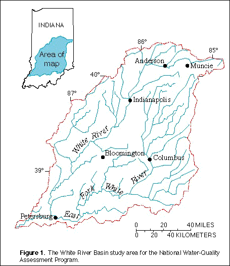
In 1991, the USGS began a study of the White River Basin in Indiana as part
of the National Water-Quality Assessment (NAWQA) Program ( fig. 1). The goal of the study is to determine
water-quality conditions and trends in the surface and ground waters of the
11,349-square-mile Basin and to understand the factors that affect water
quality. In particular, a wide variety of pesticides used in agriculture
and urban areas is being monitored in surface and ground waters to
determine concentrations and the frequency of their occurrence. Nitrogen
and phosphorous also are being studied to determine if the major sources of
these nutrients are agricultural or are discharges from sewage-treatment
plants or combined-sewer overflows. The NAWQA Program is producing a
wealth of water-quality information that is useful to policymakers and
water managers at local, State, and national levels. |

(Click on image for a larger version, 36K JPEG)
|
|
Figure 1. The White River Basin study area for the
National Water-Quality Assessment Program. |
|
|
|
|
Cooperative mapping programs between the USGS and the State of Indiana
began in the 1920's. Among the most popular products are the topographic
maps at the scale of 1:24,000 (1 inch on the map represents 2,000 feet on
the ground). These maps depict basic natural and cultural features of the
landscape, such as lakes and streams, highways and railroads, boundaries,
and geographic names. Contour lines are used to depict the elevation and
shape of the terrain. Indiana, which is covered by 710 maps at this scale,
was the first State under the program to have complete coverage. The maps
are used not only by engineers, scientists, and resource managers, but also
by the general public who enjoy hiking, exploring, and other outdoor
activities. |
The current program emphasis is on converting the Indiana primary map
series to a digital format for the growing number of computer applications,
which include the State's digital data base. Digital map products have
been developed by the USGS for Indiana at a scale of 1:100,000. These
digital files are available by computer and are used by local, State,
Federal, and private entities in resource assessments, technical
investigations, and planning. |
|
In Indiana, about 200 billion gallons of ground water are withdrawn each
year for drinking water, energy production, and industrial, agricultural,
and commercial uses. To address the need for a comprehensive publication
that details information on water-bearing units in the State, the USGS
published an atlas of aquifers in 1994. The atlas was a cooperative effort
by the USGS, the Indiana Department of Environmental Management (IDEM), and
the Indiana Department of Natural Resources (IDNR), Division of Water. |
|
|
|
The St. Joseph aquifer system, which is the only sole-source aquifer in
Indiana, was the focus of a cooperative study by the USGS and the IDNR. A
sole-source aquifer is one that supplies 50 percent or more of the drinking
water for an area and for which there are no reasonably available
alternative sources should it become contaminated. In addition to
collecting data to define the geology of the system, the investigation
included development of a computer model to determine ground-water flow
paths and to predict changes in water levels that result from theoretical
increased withdrawals. A ground-water-quality investigation includes
comparisons of samples from the deep and shallow parts of the aquifer.
The disposal of refuse and treated waste is an issue that confronts
citizens of Indiana and the Nation. The USGS, in cooperation with the
Indianapolis Department of Public Works, investigated ground-water flows at
landfills in Marion County. In one study, ground-water flow models were
calibrated with data collected at the sites to determine the amount of
water that flows through the landfills and if the leachate was reaching
shallow aquifers and nearby streams. Another study focused on ground-water
flow and water quality beneath sewage-sludge lagoons. |
The USGS has conducted extensive studies on ground-water availability
throughout the State, as well as studies that define regional ground-water
flow systems. In a cooperative study, the USGS, the city of Elkhart, and
the U.S. Environmental Protection Agency (USEPA) used a computer model to
investigate the ground-water flow system that is accessed for Elkhart's
public water supply. Results of the study indicated the extent to which
adjacent commercial and industrial sites affect the ground-water flow
system. In another study, the USGS, in cooperation with the IDNR, used a
three-dimensional digital computer model to investigate the ground-water
flow systems of a heavily irrigated area in Newton and Jasper Counties.
Results of the study indicated that a clay confining unit is the most
important component that controls the rate of recharge to the bedrock
aquifer. Results also indicated that irrigation pumpage did not exceed
recharge, even during dry years such as 1988, but may cause drawdowns that
lead to conflict among ground-water users. The information gained from
these types of studies was useful to water-resource planners and managers
in the development of regional water-management policies. |
|
|
|
The USGS's Biological Resources Division (formerly the National Biological
Service) provides scientific data on Indiana's parks, beaches, and savannas
to those Federal and State agencies responsible for managing these areas.
The Lake Michigan Ecological Station in Porter, which is a field station of
the Great Lakes Science Center (Ann Arbor, Michigan), conducts research on
the effects of contaminants in aquatic ecosystems, principally on
macroinvertebrate, plant, and animal communities. Studies are being
conducted in several national parks, which include the Cuyahoga and the St.
Croix National Scenic Riverways and the Grand Calumet Lagoons. |
Current studies include investigations of the sources, extent, and fate of
bacterial contamination, which has caused occasioal closures of some
beaches in Indiana, and associated health-related problems. Oak savannas,
which were once an extensive vegetation zone between prairie and forest
across the Midwest, have been affected by human activity and altered by
fire suppression. Studies are focusing on gathering information needed to
determine the influence of fire on the savannas and to restore them on Lake
Michigan dunes. The results of these research activities will provide
information to enable managers of natural areas to understand better the
relation between various factors within complex biological systems. |
|
|
|
In northwestern Indiana on the southern shore of Lake Michigan is a complex
area of dunes, beaches, and wetlands. This area is adjacent to a highly
industrialized zone. Because of the environmental stress created by the
industrial activities, the zone is recognized by the International Joint
Commission and the USEPA as one of the principal areas of concern in the
Great Lakes Basin. For environmental managers and community planners to
make knowledgeable decisions related to industrial, urban, and
environmental issues, there is a need for an increased understanding of the
hydrological, geological, and biological processes that occur in the lake
shore area. To fulfill this need, cooperative studies have been conducted
by many local, State, and Federal agencies. For example, in one
cooperative study, the National Park Service (NPS) and the USGS
investigated the hydrogeology and hydrochemistry of the dunes and
wetlands.
The USGS and the IDEM cooperated on a number of studies in the industrial
lakeshore area to address contamination issues and to define the complex
interaction between ground and surface waters. In cooperation with the
USEPA, ground-water-level and water-quality data have been collected to
evaluate those interactions in areas of extensive industrial and
waste-disposal activities.
The USGS operates acoustical velocity meters to monitor the flows at Burns
Ditch at Portage, the Indiana Harbor Canal at East Chicago, and Trail Creek
Harbor at Michigan City. By using acoustical technology, flow data can be
collected even during periods of complex backwater conditions. Regulators
and industrial site managers need the data to determine possible
contaminant loads into the lake. |
The quality and quantity of rain, snow, sleet, dew, or hail, in the Grand
Calumet River watershed in northwestern Indiana was the focus of another
study by the USGS and the IDEM. Selected major ions and trace metals were
monitored by collecting weekly precipitation samples at the Gary Regional
Airport from June 1992 through August 1993. Additional samples were
collected from October 1995 through December 1996.
Coastal wetlands of Lake Michigan aid in protecting the drinking water and
the shoreline communities of Indiana. Many physical, chemical, and
man-made processes have interacted to cause the deterioration of these
wetlands ever since the glaciers melted. A geographic information system
(GIS) is being used to prepare maps that describe the development and
history of wetlands. In addition to helping scientists understand
geological limits on biodiversity, these maps are used to monitor the
changes over time and to provide a predictive tool for the land-use
planners, resource managers, and political representatives who are
responsible for determining best-management practices. These
investigations have required close cooperation between the USGS, the
Indiana Geological Survey, the NPS, and the U.S. Fish and Wildlife Service. |
|
|
|
In response to the water-information needs of the individuals and agencies
required to make important economic, environmental, and regulatory
decisions, the USGS has been developing a long-term base of water-resources
data in Indiana since the early part of the 20th century. In 1996,
continuous-record data were collected at 166 streamflow-gaging stations (fig. 2), 6 stage-only stations, 80 lakes, and
94 ground-water observation wells. The IDNR, Division of Water, is the
principal State agency that cooperates in USGS data-collection programs.
Currently, more than 80 percent of the continuous hydrologic
data-collection activity is maintained through efforts cooperatively funded
by the IDNR and the USGS. Other cooperators in the data program include the
U.S. Army Corps of Engineers (USACE), the IDEM, the Indiana Department of
Transportation, and the Indianapolis Department of Public Works. |

(Click on image for a larger version, 81K JPEG)
|
|
Figure 2. Locations of streamflow-gaging stations in
Indiana in 1996. |
|
|
The USGS and the Indianapolis Department of Public Works have cooperated in
numerous water-quality investigations of the White River and its major
tributaries near Indianapolis. In the 1970's and 1980's, data collected
before and after the construction of advanced wastewater-treatment systems
were analyzed to determine the effects of the improved treatment on the
quality of the White River. In the late 1980's, the effects of storm
runoff on water quality were investigated; one study focused on the effects
of combined-sewer overflows on the water quality of the Fall Creek, which
is a tributary to the White River. Current studies focus on examining the
populations of selected aquatic organisms. Results of the studies
complement earlier efforts to examine trends in water quality and aquatic
ecosystem health of the White River. |
|
|
|
Economic growth and development in Indiana depend on continued availability
of industrial minerals for use in construction, industry, manufacturing,
and the maintenance and upgrading of the State's infrastructure. |
Limestone and dolomite, which are the leading mineral commodities produced
in the State, are rich sources of calcium and magnesium, respectively. In
raw and unrefined form, these products have many environmental uses,
particularly in cleaning smokestack emissions of coal-fired power stations.
In addition, they are vital to medicine, agriculture, and residential
consumption. Indiana is one of the Nation's leading producers of masonry
cement from limestone. The USGS has begun an assessment of the
undiscovered limestone and dolomite resources in Indiana and other States. |
|
Part of Indiana is underlain by the petroleum-producing Illinois Basin.
Because the production history is well documented in this Basin, the amount
of petroleum that has been produced can be compared with the potential
total amount contained in source rocks. This information helps in
estimating how much more petroleum can be produced. The USGS works closely
with State agencies throughout the country in acquiring the data necessary
to make such determinations. The USGS Energy Resources Program has
published a National Assessment of Undiscovered Oil and Gas Resources in a
series of three CD-ROM's in a Digital Data Series. In this series,
information on Indiana oil and gas resources can be downloaded for use in a
spreadsheet or a GIS. |
|
|
|
The Nation depends on coal as a major source of energy. Coal usage
accounts for one-third of the total energy and more than one-half of the
electricity generated in the United States. The use of coal is expected to
increase during the next century to offset dependence on foreign oil and to
sustain environmentally sound economic growth. Coal mining has an
important role in the economy of southern Indiana.
The effects of coal mining on water quality and storm runoff have been
studied in cooperative efforts between the USGS and the IDNR, Division of
Water. The results of these studies have assisted resource managers in
identifying and instituting responsible mining practices.
|
As part of a cooperative geological mapping program, the USGS is assisting
the Indiana Geological Survey in mapping minable low-sulfur coal resources
in the State. As part of the mapping program, the USGS also is assisting
in the identification of coal beds and associated horizons by means of
analyses of their microfossil content. |
|
|
|
Resource managers, scientists, industry, and other government agencies
require current standardized information on the location, quantity, and
quality of coal resources. A joint venture between the USGS and the State
Geological Surveys was initiated in 1975 to develop the National Coal
Resources Data System (NCRDS). Currently, cooperative projects are ongoing
with the 22 States that represent 98 percent of U.S. coal production.
|
A cooperative project between the USGS and the Indiana Geological Survey
began in 1982 to collect, evaluate, and correlate drillhole, mine, and
outcrop data; to encode and enter geologic and geochemical data into the
NCRDS; and to access the NCRDS data bases and software to generate new
maps, reports, and resource assessments. Continued data collection and
support of the NCRDS data bases provide baseline information that can be
accessed for annual State resource updates and to meet data needs as they
arise.. |
|
|
|
In the past decade, there has been increasing awareness that the seismic
hazard in the Eastern United States could be greater than the historic
earthquake record suggests. Since 1875, this region has experienced at
least 40 earthquakes that could be felt by residents. Recent discoveries
have shown evidence of at least seven strong prehistoric earthquakes. An
earthquake that had a magnitude of more than 7-1/2 struck about 6,000 years
ago in the Wabash River Valley near the Indiana-Illinois border. Numerous
prehistoric earthquakes of magnitude 6 to 7 have struck southern Indiana
and Illinois. Geologic evidence of these earthquakes in the form of
liquefaction-induced intrusions of sand and gravel in river sediments has
been discovered at more than 100 widespread sites in the Wabash River
Valley and along the River's tributaries. These intrusions permit the use
of geologic, archaeological, and engineering techniques to determine when
the earthquakes occurred, as well as their epicenters and approximate
magnitudes. This work has been carried out in cooperation with the Indiana
Geological Survey and archeologists from Indiana University.
|
Information about today's earthquake activity also is important to the
citizens of Indiana. The National Earthquake Information Center, which is
located in Golden, Colorado, collects, processes, and distributes
information from more than 20,000 seismic events each year. This
information is distributed in the form of alerts, bulletins, and routine
catalogs to emergency-management officials at Federal and State levels,
operators of critical facilities, the news media, the general public, and
the earthquake-research community.. |
|
The Earth Science Information Centers (ESIC's) provide information to the
public about USGS programs and products. The ESIC in West Lafayette was
established under a cooperative agreement between the USGS and the
Laboratory for Applications of Remote Sensing at Purdue University. As
part of the national ESIC network, this office provides information on
cartography, geography, digital data, remote sensing, and land use. These
types of information are useful to citizens throughout Indiana who are
involved in land planning, resource management, and environmental
monitoring and analysis. |
|
Juday Creek is a tributary of the St. Joseph River in St. Joseph County.
With its low water temperatures, sand and gravel beds, and clear water, it
is one of the few streams in Indiana that can support a brown trout
population. Since the early 1980's, however, a decline in indicator insect
species has caused concern about changes in the stream-water quality. In
1993 and 1994, the USGS, in cooperation with the IDNR and the St. Joseph
County Drainage Board, conducted a study of these changes. Results
indicated that although the observed amounts of suspended sediments would
have no direct adverse effects on the trout, the movement of sand and
gravel, which commonly are called bed-load materials, along the river bed,
could be a threat to spawning and food supplies. |
|
|
|
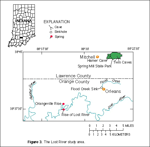
The Lost River is one of the most fascinating hydrologic systems in the
State (fig. 3). Above and Orangeville Rise,
the River drains 163 square miles of scenic hills. The Lost River is
characterized by sinkholes and streambed swallow holes into which most of
the headwaters "disappear" near the central part of the watershed. The
water that leaves the surface through these natural openings travels
underground through fractures and joints of the limestone. Most of the
water returns to the surface at the Orangeville Rise. The remaining water
resurfaces at Twin Caves, Hamer Cave, Rise of Lost River, and ohter
springs.

(Click on image for a larger version, 24K GIF)
|
|
Figure 3. The Lost River study area. | |
The Lost River Basin has been the subject of numerous studies for many
decades. In 1993 and 1994, the USGS and the USACE conducted an
investigation to define the ground-water drainage boundaries of the Basin
better and to increase the understanding of the hydrogeology near the town
of Orleans, which is subject to frequent flooding. Nontoxic fluorescent
dyes were injected into the ground-water system at selected locations, and
their reappearance was observed. On the basis of these observations,
drainage boundaries were delineated, and the directions of underground
flows were determined. In addition, hydrologic factors that contribute to
flooding at Orleans were determined. This information can be useful to
water-resource managers and planners in future flood-control designs. |
|
The USGS cooperates with numerous local, State, and Federal agencies to
conduct a wide range of scientific investigations. When local and State
agencies are involved, activities typically are funded on a matching-funds
basis. In addition to agencies already mentioned, the USGS has conducted
cooperative studies with the town of Carmel, the cities of Indianapolis,
Muncie, and Seymour; the St. Joseph River Basin Commission; the Indiana
Department of Highways; the U.S. Department of Defense; and others. |