This document is also available in pdf format: ![]() fs-014-99.pdf
fs-014-99.pdf
Urbanization of drainage areas often leads to unanticipated high peak streamflows and increased frequency of flooding within or downstream from these areas. The evaluation of the effect of urbanization on flooding requires the collection of consistent, high-quality streamflow and rainfall data, which can be used to develop computer-based models that simulate runoff processes in watersheds. Simulation results are used for planning, designing, and managing roads, bridges, culverts, dams, and flood-control reservoirs.
The U.S. Geological Survey (USGS) collects continuous streamflow and rainfall data in the suburban counties of metropolitan Chicago that are rapidly developing. These data are used to calibrate models of watershed runoff response to rainfall, which then are used to simulate runoff and flooding associated with a variety of land-use conditions and storms. A real-time rainfall gage network with radio telemetry has been installed in Du Page County. The data provided by this network entered into a linked system of model data bases, and watershed and streamflow models, to produce information that can be used to optimize reservoir operations to reduce the severity of flooding in the county. The Du Page County Department of Environmental Concerns, the Lake County Stormwater Management Commission, and the Illinois Department of Natural Resources-Office of Water Resources cooperate with the USGS in these activities.
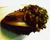 image size 48KB |
| Figure 1. Zebra mussels threaten the ecosystem by killing native mussels and by clogging water-intake structures. |
USGS scientists are working with the State and other Federal agencies to control the spread of several nonnative aquatic animals and plants that are affecting the ecology and the economy of the upper Midwest. Targeted species include the zebra mussel (fig. 1), a fast-growing invader that forms large colonies on hard surfaces. The mussel, a Eurasian species likely introduced to the Great Lakes through the release of ballast water from seagoing freighters, successfully competes with native aquatic species for space, food, and oxygen. Many industries and municipalities must perform costly maintenance to remove mussel growth from water-intake structures. Other problem species include the round goby, a recently introduced fish that may follow the path of the zebra mussel from the Great Lakes into the interior of North America, and the purple Loosestrife, an aggressive plant invader of wetland areas. Researchers are seeking to understand the biology and halt the spread of the invasive species, which threaten the integrity of native ecosystems. Scientists also are implementing a multifaceted program, involving electrified weirs and delayed-release fish poisons, aimed at restricting further range expansion of these aquatic nuisance species.
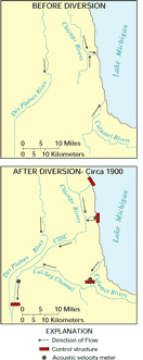 image size: 15KB |
| Figure 2. Waterways in the Chicago area before and after the Lake Michigan diversion. |
Since 1900, with the construction of the Chicago Sanitary and Ship Canal (CSSC; includes the Chicago River, Calumet River, and associated waterways), water has been diverted from Lake Michigan for domestic water supply and as direct diversion into the canal to the Des Plaines River and then to the Illinois River (fig. 2). Historically, the direct diversion by the Metropolitan Water Reclamation District of Greater Chicago (MWRDGC) was intended to protect the drinking-water supply from Lake Michigan by carrying treated sanitary wastewater away from the lake and to provide for navigation by allowing barge traffic on the Illinois River between the Mississippi River and Chicago. Currently, the direct diversion is used for water-quality improvement and navigation in the CSSC. The most recent U.S. Supreme Court decision (1967 and modified December 1, 1980) that regulates the diversion of water from Lake Michigan limits diversion by the State to a 40-year average of 3,200 cubic feet per second. The U.S. Army Corps of Engineers (USACE) is responsible for computing the diversion by the State of Illinois, and the State is responsible for allocating the diverted water.
The USACE has determined that diversion exceeded the 3,200-cubic-feet per-second limit from the 1983 to 1993 water years (the water year is from October 1 through September 30). The USGS is applying acoustic Doppler current profilers and acoustic velocity meters (AVM's), to measure flows in the Chicago River at Chicago, Calumet River at O'Brien Lock and Dam, and the CSSC at Romeoville, and leakage through the lakefront diversion-control structures. Measurements made by the USGS indicate that actual leakage through the lakefront diversion-control structures is much greater than previous estimates, and support the need for structural improvements to the control structures by the State and USACE. The USGS is responsible for the ongoing operation and maintenance of the AVM's by agreement with the USACE. The USGS is cooperating with the USACE, the Illinois Department of Natural Resources, and the MWRDGC to refine and improve the Lake Michigan diversion accounting procedures.
 images size: 15KB |
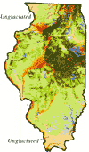
| Figure 3. Surficial glacial deposits in Illinois: glacial till deposits in green; sand-and-gravel deposits in yellow-orange; and silt and clay deposits in blue. Darker shades indicate thicker deposits and can be used to trace ancient buried valleys that are filled with complex glacial deposits across the central part of the State. |
A 1998 USGS map portrays the thickness and character of glacial deposits in Illinois (fig. 3) and adjacent States. The map complements other State maps of the glacial history and the buried-bedrock surface, all of which are used to assess ground water in glacial aquifers; susceptibility of aquifers to contamination; extent of sand and gravel for construction aggregate; and potential for earthquake, flood, radon, and coastal-erosion hazards; and for environmental and ecosystem studies. The USGS, the Illinois State Geological Survey (ISGS), and adjacent States are developing the Central Great Lakes Mapping Coalition, which plans to map priority glacial deposits at 1:24,000 scale in three dimensions using modern geophysical and drilling methods, geologic sedimentation models, and computer-assisted analyses. The multiagency mapping program will characterize the water and aggregate resources for surface and subsurface units, their geochemical composition, and their likely roles in natural hazards and contamination potential. The Coalition seeks to develop ways to teach local land-use managers and planners how to use the new, detailed data and software tools to make informed decisions for sustainable growth in the region.
 images size: 7KB |
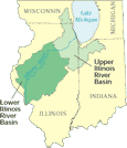
| Figure 4. Illinois River Basin National Water-Quality Assessment (NAWQA) Program study units in Illinois, Indiana, and Wisconsin. |
Protecting the quality of the Nation's water resources is a priority concern. To address this concern, scientists in the USGS National Water Quality Assessment (NAWQA) Program are collecting water-quality and biological data in the lower and upper Illinois River Basins (fig. 4). The objectives of the Illinois River Basin NAWQA study are to describe current water quality and to track long-term water-quality trends. Agrichemical and urban-related contaminants are sampled in water and sediments.
In surface-water samples from the lower Illinois River Basin, nitrate and many pesticides were detected--commonly at levels of regulatory concern--during the high-intensity data collection that ended in 1998. Ground water in the lower basin was sampled primarily for analysis of agrichemicals. Few or no pesticides were detected in water from the wells sampled, and water samples from only a few shallow wells had nitrate levels that exceeded drinking-water standards. Arsenic and radon were detected at levels of regulatory concern in ground water in the lower basin.
Intensive data collection will begin in the upper Illinois River Basin in 1999. Although agrichemicals also are a concern in the basin, a primary study objective will be the collection of samples in urbanized areas to determine the effects of urbanization on water quality and aquatic organisms. The NAWQA Program studies in Illinois have established liaison committees with representatives from Federal, State, and local agencies to help identify topics for study.
The availability of environmentally acceptable and reliable energy sources at reasonable prices is an important issue for Federal, State, and local planners. The USGS and 13 cooperating State geological surveys have developed a systematic national effort to collect, analyze, and depict data that characterize the relation between restrictions to mining and the potential for development of coal resources.
The ISGS began the first of 22 cooperative projects in the Illinois Basin in 1992. Each 7.5-minute quadrangle area selected is representative of the geologic, physiographic, land-use, and mining conditions of its surrounding area. State scientists identify land-use, environmental, technological, and geological constraints within each study area and, using geographic information systems modeling, apply these restrictions to maps of coal bed and coal-zone thickness, depth of burial, and mined-out areas. The State, after consulting with local mining experts, estimates the unmined and unrestricted tonnage of coal that remains in the ground and is available for development. In the 18 completed studies, this amounts to about 39 percent of the original coal. ISGS scientists then transfer digital files of the completed studies to the USGS. USGS geologists and engineers model mine plans, estimate future mining and washing losses, and determine potential economically recoverable coal in each study area. The amount of unrestricted coal in the Illinois Basin that can be extracted and marketed at a profit, at current costs, is expected to average about 8 percent of the original coal resource.
Under a parallel USGS--State cooperative project, the National Coal Resource Assessment, the ISGS is preparing basinwide maps, models, and resource estimates for three major coal beds--Springfield, Herrin, and Danville. Applying knowledge gained from the 18 completed studies, the ISGS, in collaboration with the Indiana Geological Survey, has begun a basinwide assessment of the availability of the Springfield coal.
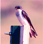
USGS scientists, in partnership with the U.S. Fish and Wildlife Service, are evaluating the amount of polychlorinated biphenyls (PCB's) in wildlife along the upper Mississippi River to determine if further management and mitigation are warranted. Great strides have been made in recent years to clean up and eliminate PCB sources in the Quad Cities' (Davenport and Bettendorf, Iowa; and Rock Island and Moline, Ill. ) stretch of the upper Mississippi River. These chemicals commonly remain trapped in fatty tissues, accumulating to toxic levels in predatory animals. Tree swallows, which feed on aquatic insects that hatch from river water and sediments, are being used as an indicator of PCB contamination and transfer up ecological food chains (fig. 5).
 images size: 52KB |
| Figure 5. Tree swallows are being studied to determine how PCB contamination in the upper Mississippi River affects wildlife. |
The USGS, in cooperation with the Illinois Department of Transportation, is acquiring photographs of the State in 1998--99 through the National Aerial Photography Program (NAPP). These black-and-white photographs are intended to be used for planning transportation and construction, studying land-use changes, and planning new subdivisions. Additionally, the NAPP photographs will be the basis for statewide digital orthophoto quadrangle (DOQ) coverage for Illinois. A DOQ is a computer-generated image of an aerial photograph and has the geometric qualities of a map.
The Illinois Department of Transportation intends to distribute NAPP photographs in Illinois. These photographs have many applications, including use in making decisions related to the environment, natural resources, natural disasters and hazards, property assessment, agriculture, and recreation.
Government agencies, the private sector, academia, and citizens rely on USGS 7.5-minute topographic maps in their work, as well as in recreational activities. In an ongoing partnership agreement with the USGS, the Illinois Department of Transportation and the Illinois Department of Natural Resources annually contribute matching funds toward updating printed USGS topographic maps, which yields many benefits to the people of Illinois.
Water-quality and -quantity data are used for monitoring, planning, designing, hazard warnings, operating, and managing water-related activities, such as water supply, hydroelectric power generation, flood control, irrigation, bridge and culvert design, wildlife management, pollution abatement, flood-plain management, and water-resources development. The USGS, in cooperation with more than 20 Federal, State, and local agencies, collects streamflow, ground-water level, and water-quality data throughout Illinois.
Through a network of 149 satellite or telephone telemetry-equipped streamflow-gaging stations (about 96 percent of all stations), streamflow data in Illinois are provided to the National Weather Service; the USACE; and other Federal, State, and local agencies to manage floodcontrol structures and reservoirs, to plan for flood mitigation, to forecast streamflow and stream levels, and for many other activities. Most of this information can be accessed on the Internet at http://il.water.usgs.gov/.
Sediment data for rivers and lakes are needed by researchers, engineers, water-resource planners, and others for a variety of applications, and are essential for monitoring water quality. Sediment impairs fish respiration and plant productivity, and can limit the aesthetic and recreational usefulness of rivers and lakes. The USGS, in cooperation with Federal, State, and local agencies, collects sediment data at several sites in Illinois. These sites include small creeks, reservoirs, and the Illinois and Mississippi Rivers.
|
USGS office locations
|
USGS State Representative USGS Home Page http://www.usgs.gov Reports and products 1-888-ASK-USGS
|