This document is also available in pdf format:
![]() fs-021-99.pdf
fs-021-99.pdf
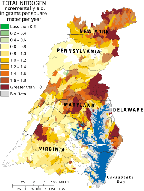
The Chesapeake Bay Program (CBP), a multiagency restoration effort, has set a goal of reducing controllable nutrients entering the Chesapeake Bay by 40 percent by the year 2000. The reduction is expected to improve dissolved-oxygen levels in the Bay. The U.S. Geological Survey (USGS) Ecosystem Program is coordinating USGS and other agencies' studies to understand the response of water quality and living resources in the Bay and its watershed to nutrient reduction and natural variability. The USGS is analyzing trends, identifying nutrient-source areas, addressing nutrient traveltimes in ground water, determining the relation of nutrients to fish health, and documenting the long-term change of the ecosystem. Since 1985, the USGS has provided water-quality information and analyzed the amounts of nutrients and sediments entering the Bay (fig. 1). An analysis of the data collected from rivers in the Bay watershed from 1985 to 1997 shows that although the amounts of nutrients and sediments delivered to the Bay may have increased, the concentrations of nutrients and sediments in many rivers are decreasing or remain the same.
| Figure 1. Total nitrogen yields from stream reaches in the Chesapeake Bay watershed. |
The USGS also is relating sources of nutrients to amounts of nutrients delivered to the Bay by using a statistical model called SPARROW. The SPARROW model is being adopted by the CBP as one of the tools used for identifying Nutrient Areas of Concern. SPARROW calculations also will be used to explain the trend results and to link nutrient sources to nutrients in ground-water loads and their delivery to surface water.
The USGS is providing preliminary information on the amount and traveltime of nutrients in shallow aquifers in the Bay watershed. Initial findings indicate that about half of the water and nutrients entering the Bay travel through the ground-water system. Nutrients may move through ground water for several years or several decades before reaching rivers or the Bay, thus significantly delaying the benefits of nutrient-reduction measures implemented on land.
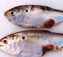
Reports of high numbers of fish with skin lesions in the Pocomoke River and other tributaries of the Chesapeake Bay have stimulated a great deal of public and scientific interest (fig. 2). The USGS, in cooperation with the State of Maryland, assessed fish health in five tributaries of the Chesapeake Bay throughout the spring, summer, and fall of 1998 in response to concerns about Pfiesteria, a toxic marine microorganism. This microorganism is believed to be the cause of some estuarine fish kills and lesion outbreaks, primarily in menhaden, as well as having potential human-health implications. Although fish kills of this origin did not occur in 1998, lesioned menhaden were collected from the Pocomoke, Wico-mico, and Choptank Rivers during the USGS fish-health assessments. Examination of the lesions showed that all of them contained an invasive fungus, suggesting that these particular lesions were not necessarily caused by Pfiesteria. Further research will be directed toward understanding the invasiveness of the fungus, causes of stress that may be necessary for infection, and what environmental factors are related to the high incidence of these fungal lesions in menhaden.
| Figure 2. Menhaden with lesions; Wicomico River, August 1998. |
Although environmental problems such as pollution, urbanization, and deforestation commonly are attributed to human activities in the Bay's watershed, it is now recognized that climatic factors also strongly influence the salinity, temperature, and water quality of the Bay. Concern about the Bay's future is especially acute for policymakers and landresource managers who are faced with questions such as: Will the anomalously high and variable river discharge of the past decade continue? What will be the future effect of possible changes in mean-annual rainfall projected by climate models? How will the changes in river discharge and rainfall affect nutrients and levels of dissolved oxygen in the Bay? Have unique climatic and hydrologic conditions contributed to recent toxic algal blooms?
The above subjects are being addressed as part of a USGS interdisciplinary research project investigating year-to-year through long-term variability in salinity, sediment accumulation rates and budgets, dissolved oxygen, temperature, sea level, and plant and animal trends, using fossil and geochemical data from Chesapeake Bay sediment cores.
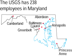
The USGS and its cooperative partners are developing an approach to maintaining an efficient stream-gaging network in Maryland (fig. 3) through the Maryland Water Monitoring Council. These efforts produced a gain of several important gages in the statewide network in 1998.
| Figure 3. Locations of USGS stream-gaging stations in Maryland. |
A Council workgroup investigated the status of stream gaging in Maryland and the issues related to continued operation and needed growth of the current network. A workgroup is focusing on two specific aspects of stream gaging: the representativeness of the principal physical characteristics of Maryland watersheds, and an inventory of streamflow data users and their applications. Preliminary analyses show that some important geographic areas of Maryland and certain significant physical characteristics are not well represented by the current network.
The USGS, in cooperation with the Maryland Geological Survey (MGS), produces technical papers and maps about the geology of Maryland. Since 1968, these organizations have mapped bedrock and surface geology throughout Maryland at scales of 1:62,500 and 1:24,000. This includes 1:24,000-scale mapping of the Maryland Piedmont region since 1974. Geologic maps contain information that can be used for a wide range of public and private applications such as land-use planning; ground-water availability and quality studies; finding and making the best use of earth resources, such as natural aggregate for construction; hazard assessment; and engineering and environmental studies for waste-disposal sites and construction projects.
The USGS, in cooperation with the MGS, is producing a geologic map of the Chesapeake and Ohio Canal National Historical Park for the National Park Service. Personnel of the Appalachian Geology and Hydrology Project (conducted in cooperation with the MGS) map geology in the urban, suburban, and outlying rural areas of the Washington-Baltimore region. The results of the project will be 1:100,000-scale geologic maps on paper and in electronic formats.
A USGS study of South American nutria showed the destructive effect of these large exotic rodents on marsh habitats in Maryland's Blackwater National Wildlife Refuge. The research was conducted with the USGS Maryland Cooperative Fish and Wildlife Research Unit, Maryland Department of Natural Resources (DNR) and the U.S. Fish and Wildlife Service.
Research on the role of the plant-eating nutria in marsh loss is also of special interest to the Chesapeake Bay Program, which seeks to achieve "no net loss" of wetlands within the Bay watershed. Introduced in the 1940's to bolster Maryland's Eastern Shore fur industry, the South American nutria (fig. 4), which is 4 to 10 times as large as a native muskrat, has been implicated in the loss of emergent marsh, especially along the Blackwater River in Dorchester County. Marsh loss has coincided with the introduction and expansion of the nutria population.
| Figure 4. Large South American nutria. |
A recent study found that within the Blackwater National Wildlife Refuge, 3,500 acres of marsh have been lost to open water since the late 1930's, and 53 percent of remaining marsh is considered unhealthy. Although other factors, such as rising sea level, also contribute to marsh loss, nutria have accelerated the problem during the past two decades—primarily because a decline in the fur industry has led to overpopulation of the rodent in lower Eastern Shore marshes.
The overabundance of nutria and the rapid loss of marsh in this region have prompted State legislation proposing a 10-year nutria eradication program. The relation between nutria feeding habits and marsh loss, however, remains unclear, and a long-term eradication program awaits evidence of cause and effect. The USGS study is intended to determine if excluding nutria from emergent marsh habitats can stabilize or recover marsh vegetation. Aerial photography and ground-plot measurements are being used to detect changes.
Research results have already demonstrated the need for animal-control activities to preserve the marsh. Future results are intended to enable natural-resource management agencies to determine if more intensive marsh recovery efforts are needed to restore the more heavily damaged areas.
A study team from the USGS and the University of Maryland Baltimore County (funded by NASA's Mission to Planet Earth) is developing a data base reflecting 200 years of urban development in the Baltimore-Washington metropolitan area. Other organizations, such as the Smith-sonian Institution and the Bureau of the Census, have entered into this partnership to enhance the scope of the data base.
Urban areas have a strong impact on local land use and land cover. Modern urban settlements are characterized by the proliferation of asphalt and concrete surfaces. Land-cover changes associated with an urban area can be immense. The effect of urban land on economic and environmental systems is significant compared to its areal extent.
The Chesapeake Bay's delicate ecosystem has been affected negatively by increasing urban growth. A data base has been developed by combining information from a variety of sources into an integrated, multi-scale, multiresolution data set. This data base reflects regional urban growth from 1792 to 1992.
Temporal urban maps depict past landscapes by combining historical maps, census statistics, and commerce records to generate progressive pictures of urban growth in the Baltimore-Washington region during the past two centuries. Remotely sensed data, existing digital land-use data, digital census information, earth-science data such as digital line graphs, digital elevation models, and demographic information are used for analysis.
The USGS is conducting environmental assessments in the Mid-Atlantic region, including parts of Maryland and the District of Columbia. The USGS assessed regional water quality in the Delmarva Peninsula (1986-91); and the Potomac River Basin (1991-98) as part of the National Water-Quality Assessment (NAWQA) Program.
The Delmarva study showed that agricultural and residential land use have affected ground-water quality. High concentrations of nitrate are found in ground water in most parts of the surficial aquifer, including deep parts of the aquifer used for water supply. Pesticides used on common crops were found at trace concentrations in very shallow ground water, but pesticides generally were not found in deeper parts of the ground-water system.
The Potomac study also showed that land use is an important factor in water quality. The highest concentrations of nutrients and pesticides in streams and ground water in the Potomac River Basin were found in areas of intensive row cropping underlain by carbonate rock. The study also showed that concentrations of nutrients and pesticides in ground water and streams generally are less than levels that would adversely affect human health or most ecosystems.
In addition the USGS is developing hydrologic and water-quality information that is intended to assist U.S. Environmental Protection Agency (EPA) researchers in the Landscape Ecology Branch in developing landscape indicators for pesticides and nutrients in surface water. This project, which includes regionwide sampling of streams, is being done in conjunction with NAWQA studies of regional ground-water-quality patterns in the Mid-Atlantic Coastal Plain (from New Jersey to North Carolina).
The USGS ensures the availability of map data in paper and electronic form by fostering partnerships among State and Federal agencies to improve data collection and resource sharing. The DNR, in cooperation with the USGS, is producing 571 1:12,000-scale color-infrared digital orthophoto quadrangles (DOQ). The DNR will produce the DOQ's to be fully compliant with the current Federal Geographic Data Committee meta-data standards. This will complete the DOQ-data coverage in Maryland, which will be made available to the public through the USGS Earth Resources Observation Systems Data Center in Sioux Falls, South Dakota.
USGS scientists, in cooperation with the MGS, Virginia Division of Mineral Resources, Resources for the Future, National Center for Resource Innovations, and the National Stone Association, are analyzing how population growth and development zoning regulations, and changes in land-management practices have influenced and controlled the availability of sand, gravel, and crushed stone (aggregate) and aggregate production in the Washington-Baltimore urban corridor during the past 20 years. Projecting these trends into the future is intended to aid planners with resource allocation. Estimates of the end uses for aggregates suggest that about 78 percent of aggregates produced in the region is used to maintain, improve, and modify existing buildings and roads, and 22 percent of produced aggregate is for constructing new buildings and roads.
Regional growth during the last 10 years includes increased population, housing units, and roads in the 17,000-square-mile region. In 1995, 76 million metric tons of natural aggregates, worth $480 million, were produced and consumed. By 2010, the population of the region is projected to grow by 14 percent, and demand for natural aggregates is projected to exceed 86 million metric tons per year. The projections suggest that vast quantities of crushed stone and sand and gravel will be needed. Most of this aggregate will have to come from resources yet to be delineated or defined.
The Safe Drinking Water Act Amendments of 1996 establish an emphasis on delineation of source-water areas and require an inventory of the potential sources of contamination for each public water supply. In response to this directive, the USGS is cooperating with the Maryland Department of the Environment (MDE), MGS, and Baltimore City on several source-water assessment projects. The USGS, MGS, and MDE are conducting ground-water-quality surveys of gross-alpha and radium content of water in water-supply wells throughout the outcrop portions of the Magothy, Patapsco, and Patuxent aquifers in the Atlantic Coastal Plain to determine the distribution and concentrations of radium. In addition, these studies are correlating contributing factors, such as low pH and high chloride content of ground water, to observed radium concentrations greater than the EPA's Maximum Contaminant Levels for drinking water.
Many water-supply wells in the Coastal Plain tap the shallow unconfined aquifer, which makes them vulnerable to contamination from disease-causing organisms. To determine the susceptibility of these water-supply wells to such pathogens, the USGS and MDE are identifying and documenting the occurrence of organisms such as viruses in the shallow unconfined aquifer on the Eastern Shore of Maryland.
Loch Raven Reservoir, created in 1881, supplies drinking water to the Baltimore metropolitan area. The USGS, MGS, Baltimore City, and MDE are creating a bathymetric map of the reservoir from field data and developing maps of sediment deposition since 1914, to record the change in storage capacity and sediment accumulation over time.
|
USGS office locations
|
USGS State Representative USGS Home Page: Reports and products: |