Banner

Index of Subjects

For more than 100 years, the United States Geological Survey (USGS) has provided earth-science information on which managers, scientists, and other interested citizens base decisions regarding Michigan's natural resources and natural hazards. The non-regulatory and scientific nature of the USGS work ensures that our products are technically sound, unbiased, and equally accessible and available to all interested parties. The various programs of the USGS in Michigan reflect a response to the citizens of Michigan and their need for geologic, topographic, biologic, and hydrologic information. Much of the work of the USGS in Michigan is part of cooperative programs in which the diversity of interests among local, regional, State, Tribal, and Federal agencies is accommodated through joint planning and funding.

-----

Michigan's Coastal Wetlands

The coastal wetlands of the Great Lakes protect the drinking water and shoreline communities of Michigan. Many physical, climatic, and other processes have been interacting to cause the deterioration of Lake Michigan's wetlands since the glaciers melted. Histories of wetlands along the Michigan coast are included in a Geographic Information Systems (GIS) map that is being prepared for Lake Michigan. Monitoring the changes of wetlands through time using these maps will provide a predictive tool for land-use planners, political jurisdictions, and scientists who need to understand the geological limits on biodiversity. Developing the ability to predict the response of Michigan's coastal wetlands to natural processes and human activities has involved close cooperation with Michigan Department of Natural Resources and the Michigan Geological Survey, Michigan Technical University, Michigan State University, the University of Michigan, and several other Federal agencies.

-----

Contaminant Pathways to the Great Lakes

The Great Lakes are a magnet for the visitors who make tourism and recreation a 14 billion dollar per year industry in Michigan ( figs. 1 and 4). Contamination of the Great Lakes ecosystem limits recreational uses, threatens productivity of commercial and sport fisheries, and increases costs of water-supply treatment. From 1974 through 1994, the USGS collected water-quality samples from 24 Michigan tributaries to the Great Lakes as part of the National Stream Quality Accounting Network. Currently, two National Water Quality Assessment (NAWQA) Program studies are underway in Michigan--the Western Lake Michigan and the Lake Erie-Lake St. Clair.

Figure 1

(Larger Version, 291K GIF)

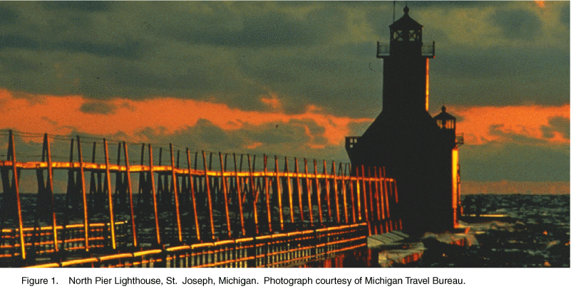
Figure 1. North Pier Lighthouse, St. Joseph, Michigan. Photograph courtesy of Michigan Travel Bureau.

The long-term goals of the NAWQA program are to describe the status and trends in the quality of a large, representative part of the Nation's surface- and ground-water resources and to identify the natural and human factors that affect their quality. The NAWQA program provides a wealth of water-quality information useful to water managers at the local, State, and National levels. Recently, the USGS calculated annual contaminant loads from major rivers tributary to Lake Michigan for the Michigan Department of Environmental Quality and calculated annual contaminant loads to the Detroit River from combined sewer overflows for the City of Detroit and Southeast Michigan Council of Governments.

-----

Collection of Water Data

Michigan has abundant surface-water resources. In virtually all parts of Michigan, the quantity, quality, and distribution of water are critical to the State's economy. The USGS operates and maintains statewide networks of monitoring sites at which surface-water, ground-water, and water-quality data are collected and recorded on a continuous basis. All data are stored in computer files, available through the Internet, and published annually. Real-time data from more than 40 streamflow monitoring sites are available on the Internet.

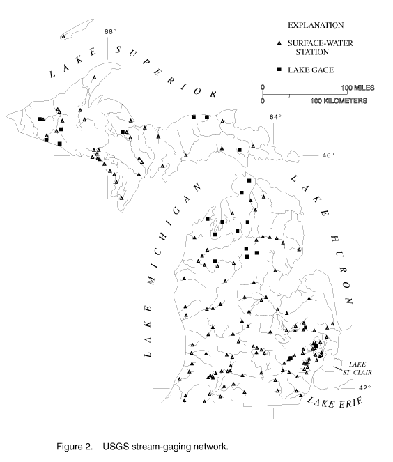
USGS data networks are critical for long-term management and day-to-day administration of water resources. Long-term data from the 140 stream gages in Michigan ( fig. 2) are used by various agencies to design bridges and culverts, for predicting peak flows, and for floodplain mapping to minimize flood damages. Hydroelectric utility operators, wastewater-treatment-plant operators, and the National Weather Service use streamflow data on a daily basis. Additionally, managers of fisheries and wildlife sanctuaries use USGS streamflow data during periods critical to maintaining suitable habitats for the fauna and flora they manage. A historical record of water data provides a foundation on which to build future investigations and a firm basis for planning

Figure 2

(Larger Version, 194K GIF)

Figure 2. USGS stream-gaging network.

-----

Biological Studies in the Great Lakes Ecosystem

The USGS Biological Resources Division (formerly the National Biological Service) provides scientific information for restoring, enhancing, managing, and protecting living resources and their habitats in the Great Lakes ecosystem. The USGS Great Lakes Science Center in Ann Arbor investigates Great Lakes fish communities, aquatic habitats, coastal and wetland habitats, and develops ecosystem-models using long-term data bases to assess disturbances on the Great Lakes. In addition to the Ann Arbor Laboratory, the Center operates seven field stations and five large research vessels, one on each of the Great Lakes, to facilitate research conducted over this large geographic area.

Major research programs include fish-stock assessment and community dynamics, aquatic habitat and food-web interactions, nearshore and wetland habitats, terrestrial ecology, and exotic species. Long-term research is conducted on Great Lakes fish populations to identify the factors impeding restoration of native species. Research on aquatic and wetland habitat is used to assess the effectiveness of ecological restoration efforts and to evaluate alternative management actions to minimize adverse effects on the diversity and sustainability of native communities. Researchers use a combination of field, laboratory, and modeling studies to provide information pertinent to prevention, containment, and control of exotic species such as the zebra mussel, ruffe, and sea lamprey. Terrestrial research is primarily conducted in Great Lakes National Parks and Lakeshores with emphasis on protection and restoring unique Great Lakes habitats, including sand dunes, grasslands, and savannas.

Other research is being conducted in the State through USGS Environmental Technical Management Center, which is collaborating with the Michigan Department of Natural Resources and others in a regional effort to map current vegetation and terrestrial vertebrate distribution. This study is in support of the Upper Midwest Gap Analysis Program to identify significant ecological areas and gaps in biodiversity conservation.

-----

Ground-Water Availability

Ground water is the major source of drinking water for domestic supplies in Michigan and for municipal supplies in Lansing, Battle Creek, Kalamazoo, and Jackson. Throughout Michigan, the availability of ground water is a significant issue because of competing uses, particularly during periods of drought. The USGS has investigated the availability of ground water in many counties, including Grand Traverse, Huron, Kalamazoo, Marquette, Monroe, Oakland, and Washtenaw. In the Greater Lansing Area, the USGS developed a computer model of ground-water flow to more than 200 municipal wells. The model is being used by the Tri-County Regional Planning Commission Groundwater Management Board to develop a wellhead protection plan and to predict the effects of future water-supply development.

-----

Prehistoric Great Lakes Levels

USGS studies show that prehistoric levels of Lake Michigan and Lake Huron exceeded modern-day fluctuations ( Fig. 3). Prehistoric variations in the levels of Lake Michigan have exceeded (by as much as a factor of 2) the 1.6-meter range of fluctuation that spanned the 1964 low level and the 1985-87 high level. One documented high-level episode occurred in the 17th century before the region was widely settled. Lake Superior levels show a similar history, although the range of prehistoric fluctuation exceeded 2 meters in comparison with the modern range of 1.0 meter. Studies by the USGS and the Michigan Sea Grant Program conducted at Bay Mills, Michigan, on the south shore of Lake Superior, near Sault Ste. Marie have documented episodes of low lake levels over the past 2,000 years with mean levels 1.5 meters lower than the present mean level of 183.4 meters. Such episodes of higher and lower levels resulted from natural climate changes in the region. Greater and lesser lake-level fluctuations related to future natural climatic changes are not only possible, but are probable. The impact of possible global warming on the magnitude and frequency of water-level changes remains uncertain.

Figure 3

(Larger Version, 194K GIF)

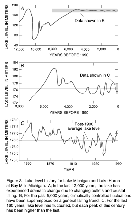
Figure 3. Lake-level history for Lake Michigan and Lake Huron at Bay Mills Michigan. A; In the last 12,000 years, the lake has experienced dramatic change due to changing outlets and crustal tilting. B; For the past 5,000 years, climatically controlled fluctuations have been superimposed on a general falling trend. C; For the last 160 years, lake level has fluctuated, but each peak of this century has been higher than the last.

-----

Submergence of Lake Superior Shorelines

The most recent period of glaciation loaded and depressed the land surface in the Great Lakes area until about 9,000 years ago. With the melting of the glaciers, the region is slowly tilting from northeast to southwest as the land surface "rebounds" from the weight of the former ice. Lake Superior is being tilted in a similar manner. Here, however, the outlet channel to the lake at Sault Ste. Marie is rising more rapidly than most other points along the U.S. shore of the lake. As the outlet spillway, which controls the level of lake rises, the south shore of the lake is progressively inundated from east to west. The amount of inundation is greatest at Duluth, Minnesota where as much as 5.4 meters of inundation has occurred over the past 2,000 years. Maximum inundation over this period for the Michigan shore occurred near Ontanogan where as much as 3 meters is noted.

-----

Agricultural Chemicals in Ground Water

Agriculture and related products are a 37 billion dollar per year industry in Michigan. About 29 percent of Michigan's land is used for agriculture. Agricultural chemicals greatly enhance the productivity of cropland, yet are potential threats to safe, drinkable ground-water supplies. Agricultural and health agencies need to know the susceptibility of ground-water resources to contamination from agricultural chemicals to develop stewardship practices. The USGS, in cooperation with county health agencies in Huron, Grand Traverse, Kalamazoo, Monroe, and Van Buren Counties completed water-resources studies in five major agricultural counties. In Kalamazoo County, which relies on a shallow glacial deposits for all its water, the USGS sampled wells, located areas of contamination, and mapped the susceptibility of the aquifer to contamination. The Kalamazoo County Health Department used the USGS findings to recommend deeper wells in some areas, the expansion of municipal water systems, and to develop a ground-water protection strategy for the County. In Kent County, the USGS is working cooperatively with the Michigan Department of Agriculture to determine the susceptibility of ground water to contamination by pesticides.

-----

Topographic Mapping

Among the most popular and versatile products of the USGS are its topographic maps at the scale of 1:24,000 (one inch on the map represents 2,000 feet on the ground). These maps depict basic natural and cultural features of the landscape, such as lakes and streams, highways and railroads, boundaries, and geographic names. Contour lines are used to depict the elevation and shape of terrain. Michigan is covered by 1,282 maps at this scale, which is useful for civil engineering, land-use planning, natural-resource monitoring, and other technical applications. These maps have long been favorites with the general public for outdoor uses, including hiking, camping, hunting, exploring, and back-country fishing expeditions.

Michigan has established a multi-agency effort to support computer mapping and data exchange known as Improving Michigan's Access to Geographic Information Networks (IMAGIN). The IMAGIN consortium, which involves the Library of Michigan, Michigan State University, the Department of Natural Resources, and the Legislative Service Bureau, is working to support the use of geographic information systems (GIS) in Michigan. Functions of IMAGIN include developing methods and standards for geographic data exchange, expanding access to geographic information, and increasing public visibility of GIS products through the state's library system. USGS representatives participate in IMAGIN activities by providing workshops sponsored by the Federal Geographic Data Committee and holding topical forums. The USGS also works with Federal, State and local agencies in Michigan to produce and provide cartographic data for a variety of GIS applications.

The USGS is cooperating with the U.S. Army Corps of Engineers, Detroit District, to produce digital elevation models (DEM's), digital line graphs (DLG's), and digital orthophotoquads (DOQ's) in southeastern Michigan. The digital data will provide the Engineering and Planning Division with digitized terrain information (DEM's), map features such as roads, streams and lakes (DLG's), and recent aerial photographs in computer format (DOQ's) to be used in project planning, spatial analysis and other GIS applications.

The USGS is cooperating with the Wayne County Department of the Environment to produce digital elevation data in southeastern Michigan. These data will support Wayne County's research efforts for the Rouge River National Wet Weather Demonstration Project by providing topographic data used in surface modeling.

The USGS is cooperating with the U.S. Forest Service and the Natural Resources Conservation Service to produce DOQ's for several areas in Michigan. The DOQ's for the Ottawa and Hiawatha National Forests in the Upper Peninsula will provide an image base or "snapshot" of the region that will be used for natural resource planning. Orthophotos are planned for parts of Marquette, Alpena, Montmorency, Otsego, Kalkaska, Clinton and Monroe counties to serve as a base for digital soil-mapping activities.

-----

Mineral, Oil, and Gas Resources

Economic growth and development in Michigan depends, in part, on the availability of local sources of minerals, oil, and gas for use in industry, manufacturing, and maintaining and upgrading the region's infrastructure. The USGS has developed an integrated digital geologic, geochemical, geophysical, and mineral resource database and assessment of undiscovered mineral resources for Michigan. This database can be used to address regional land use, environmental, and mineral-resource issues. One recent product is a new digital bedrock geologic map for the tri-state area of Minnesota, Michigan, and Wisconsin. The USGS has also recently assisted the EPA in reviewing the permit application for solution mining at the White Pine mine in northern Michigan.

New potential gas resources in fractured shales located in the deepest part of the Michigan geologic basin (centered in the Lower Peninsula of Michigan) have been investigated by the USGS. This study assesses the geologic structure, stratigraphy, fracturing, and reservoir characteristics, as well as the potential quantity and production from the Michigan basin. Such knowledge is extremely important for identifying this region's contribution to the Nation's supply of clean-burning fossil fuel.

-----

Mineral Resource Information

The USGS Mineral Resource Data System (MRDS) is a digital database of more than 110,000 mineral sites in the United States and worldwide. MRDS provides up-to-date information on mineral occurrences and related data to support USGS research and mineral-resource assessments. MRDS also is a principal tool for providing mineral-related information to Federal and State agencies, industry and the public. The records in this database are compiled from the findings of USGS studies and other published data. MRDS contains information on more than 180 sites in Michigan that mostly describe occurrences of iron and copper. A CD-ROM of the database is being prepared.

-----

Earth Science Information

The Earth Science Information Centers (ESIC's) provide information about USGS programs, products and technological developments to the public. The ESIC in Lansing was established under a cooperative agreement between the USGS and the Michigan Department of Natural Resources. As part of the National ESIC network, this office provides information on such natural-science topics as biology, cartography, geography, digital data, remote sensing, geology, geophysics, geochemistry, hydrology, geohydrology, aerial photography, and land use. It is supported by the USGS with reference materials, technical assistance, training and outreach activities, and access to USGS data bases.

-----

Surface Geology-Berrien Co.

The USGS recently conducted a surficial geologic mapping school that included a team mapping exercise around Benton Harbor in Berrien County, Michigan, a site that contains a "renaissance zone" for urban renewal in the Benton Harbor area, an actively eroding coastal margin, dynamic flood plains, and an extensive agricultural base. The mapping team was composed of geologists from both the USGS and state geological surveys of the Great Lakes states. The geologists mapped and interpreted the three-dimensional architecture of glacially transported materials and subsequent deposits resulting from modern erosion and deposition. This team gathered and assembled data in a GIS format in a short time while in the field. Managers and planners in the Benton Harbor area can use the digital spatial information to resolve planning issues including resource assessment, aquifer modeling, ground-water quality, and hazard mitigation. A poster with maps displaying the results of the field work is available from the USGS State Representative.

Figure 4

(Larger Version, 291K GIF)

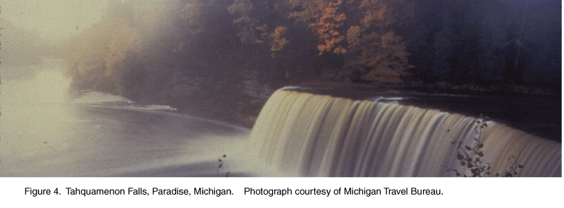
Figure 4. Tahquamenon Falls, Paradise, Michigan. Photograph courtesy of Michigan Travel Bureau.


from U.S. Department of the Interior, U.S. Geological Survey, Fact Sheet FS-022-96

For more information contact any of the following:

USGS state representative
6520 Mercantile Way, Suite 5
Lansing, Michigan 48911-5991
Phone: (517) 887-8903
Fax: (517) 887-8937
Email: Email: dc_mi@usgs.gov

Additional earth science
information can be found by
accessing the USGS Home Page
on the World Wide Web at
http://www.usgs.gov/

For more information on
all USGS reports and products
(including maps, images,
and computerized data), call
1-888-ASK-USGS

The USGS provides maps, reports, and information to help others meet their needs to manage, develop, and protect America's water, energy, mineral, biological, and land resources. We help find the natural resources needed to build tomorrow and supply the scientific understanding needed to help minimize or mitigate the effects of natural hazards and environmental damage caused by natural and human activities. The results of our efforts touch the daily life of almost every American.


This fact sheet is also available in pdf format:

 fs-022-96.pdf 194K

USGS Fact Sheets (listed by state)

Maintainer: USGS Fact Sheet Team. If you have suggestions for this page, please let us know!

http://water.usgs.gov/lookup/get?fs02296
Web version by: Genevieve Comfort
Last modified:10:19 02 FEB 98 ghc