|
|
For more than 100 years, the U.S. Geological Survey (USGS) has provided
earth-science information needed to understand and manage the Nation's
energy, land, mineral, and water resources. Such information is the basis
for many decisions regarding management of Missouri's natural resources.
Information provided by the USGS is used to address major environmental,
economic, and health issues, such as hazardous wastes in the environment,
the adequacy of suitable water supplies, nutrients in streams and
estuaries, the distribution of mineral resources, and the environmental
effects of urban development and agriculture.
|

|
|
|
|
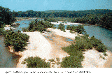
During the last 100 years, stream channels in the Ozarks have become wider
and shallower and deep-water fish habitat has been lost. Historical data
indicate that channel disturbances have resulted most directly from
clearing of vegetation along stream channels, which decreases bank
strength. Because recreational fishing is important to the economy of the
Ozarks, degradation of aquatic habitat is of concern to Federal, State, and
local land managers. The USGS is involved in a comprehensive,
multidisciplinary study to determine the cause-and-effect link between
historical land-use changes in the Ozarks and stream instability, to
evaluate the effects of stream instability on the quality and stability of
physical aquatic habitat, and to develop a predictive understanding of how
future land use and climate change will affect the aquatic ecosystem. The
study results can be used by land managers to optimize aquatic habitat
maintenance and improvement efforts and to plan for the future. Historical
and stratigraphic data show that after 1830, Ozarks streams responded to
land-use changes by depositing more gravel and less muddy sediment,
compared to presettlement conditions. Because less muddy sediment is being
deposited on flood plains, many streambanks now lack cohesive sediments,
and, therefore, no longer support steep banks (fig. 1). Analysis of
aerial photographs from the last 50 years indicates that once stream
channels have been disturbed, vegetation has a minor role in
re-establishing channel recovery. Land-use statistics indicate that the
present trend in the rural Ozarks is toward increased populations of cattle
and increased grazing density; this trend has the potential to continue the
historical stream-channel disturbance by increasing storm-water runoff and
sediment supply. |
(Larger Version, 388K GIF)
|
|
Figure 1. Midchannel gravel bar and bank erosion in the
Current River near Van Buren. (USGS photo)
|
|
|
|
|
|
|
A new set of USGS maps shows geological and geophysical information that
can be used by earth scientists and engineers to understand the causes and
likely effects of earthquakes in the New Madrid seismic zone of Missouri,
Arkansas, Tennessee, and Kentucky. The New Madrid seismic zone is the site
of the largest series of earthquakes to strike the continental Unites
States in recorded history. The new maps were made jointly by the USGS,
State, university, and private-industry scientists. The maps show, for
example, the location of earthquakes, the instruments used to study them,
faults and other buried geological structures, earthquake-generated
features that date from 1811 to 1812, and large prehistoric shocks.
Another new USGS map of the central United States shows the main roads,
railroads, oil and natural gas pipelines, dams, nuclear facilities, and
urban areas that might be at risk from a New Madrid-style (8.4 to 8.7 on
the Richter scale) earthquake. This map could be useful for planning
responses to regional earthquake emergencies. |
The National Geological Mapping Program and the National Earthquake Hazards
Reduction Program are providing a basic geologic data base for the area
between St. Louis, Missouri, and Memphis, Tennessee, including Missouri,
Illinois, Kentucky, Tennessee, and Arkansas. USGS scientists are
conducting geologic studies in Missouri in the areas of the Fort Leonard
Wood Military Reservation (FLWMR) in south-central Missouri, the Ozark
National Scenic Riverways, and the Benton Hills in southeastern Missouri.
Fractures found in the geologic formations that are visible at Earth
surface in the FLWMR area have been analyzed. The study at the Ozark
National Scenic Riverways is being conducted in cooperation with the
National Park Service and it is focusing on hydrogeologic features and
fracture analysis to provide a data base for future geologic and hydrologic
investigation in the area. Geologic studies in cooperation with the
Missouri Department of Natural Resources, Division of Geology and Land
Survey, in the Benton Hills have evaluated the earthquake potential of the
area in relation to the New Madrid seismic zone, which is about 3 miles to
the south. Trenches excavated across the English Hill Fault during 1995
document surface rupture along this fault sometime during the past 12,500
years. This is the first identification of such recent earthquake-induced
faulting in the middle Mississippi River Valley outside of the New Madrid
seismic zone and it indicates that a large region probably is prone to
seismic activity.
|
|
|
|
|
|
Among the most popular and versatile products of the USGS are the
1:24,000-scale topographic maps (1 inch on the map represents 2,000 feet on
the ground). The maps depict basic natural and cultural features of the
landscape, such as lakes and streams, highways and railroads, boundaries,
and geographic names. Contour lines are used to depict the elevation and
shape of terrain. Map coverage of Missouri consists of 1,299 maps at this
scale, which is useful for civil engineering, land-use planning,
natural-resource monitoring, and other technical applications. The maps
are favorites with the general public for outdoor uses, including hiking,
camping, exploring, and back-country fishing expeditions. Today,
scientists and engineers depend increasingly on computerized base maps for
their research and analyses. Therefore, the USGS has been producing
computerized map products in cooperation with Federal and State agencies. |
The Mid-Continent Mapping Center (MCMC), located in Rolla, is part of the
National Mapping Division of the USGS. It is a production, research, and
data management facility for maps and digital cartographic products. The
MCMC also houses an Earth Science Information Center (ESIC) and Visitors'
Center. |
|
|
|
|
|
The USGS Biological Resources Division conducts studies relating to systems
research, including topics associated with large rivers and their flood
plains, statewide biomonitoring, development of methods to use spatial data
at the landscape scale, and toxicological and ecological assessment of
acidic-mine drainage restoration efforts. Studies of the Missouri River
include pallid sturgeon habitat and behavior, contaminant effects on
riverine life forms, river channel and flood-plain land-cover patterns,
benthic fish database management, and a monitoring plan. A monitoring
program for the Upper Mississippi River system, including the part
bordering Missouri, is the largest river-related inventory, monitoring,
research, spatial analysis, and information-sharing program in the United
States. Collected data are being used to assess the potential effects of
natural and human-induced activities on the riverine ecosystem. Among
individual species covered by studies conducted in the state are mourning
doves, bobwhite quail, Canada geese, and various duck species. Other
studies include habitat relations of stream sport fishes, effects of
pesticides on and recovery of the endangered Indiana bat, recovery of the
endangered Niangua darter, and effects of habitat degradation and
lead-mining activities on the Neosho madtom. Methods are also being
developed for monitoring the biological resources of National Park Service
units in Missouri, for documenting the effects of past climate change, and
for developing simulations of future change in streams in the Ozarks. |
USGS facilities conducting biological research in the State include the
Midwest Science Center, the Environmental Management Technical Center, the
Missouri Cooperative Fish and Wildlife Research Unit, and the Northern
Prairie Science Center. |
|
|
|
|
|
The long-term goals of the National Water-Quality Assessment (NAWQA)
Program are to describe the status and trends of the quality of a large
representative part of the Nation's surface- and ground-water resources and
to identify the natural and human factors that affect their quality. The
NAWQA Program produces water-quality information that can be used by
policymakers and water managers at the Federal, State, and local levels. |
The extensive karst features of the Ozarks create a complex hydrologic
system that results in rapid interactions between surface and ground water.
The Ozark Plateaus NAWQA study, initiated in 1991, determined that the
factors that affect water quality are climate, physiography, soils, water
use, land use, population, and geology. Poultry, cattle, and swine
production, in addition to septic tanks and sewage- treatment plants, have
affected water quality by increasing concentrations of nutrients and
bacteria in water. Surface- and ground-water quality has been
significantly degraded by drainage from abandoned lead and zinc mines in
the Tri-State District of Kansas, Missouri, and Oklahoma and the Old Lead
Belt in southeastern Missouri. Recent lead mining in the New Lead Belt in
southeastern Missouri has caused concerns about water quality in the area.
Increased concentrations of radionuclides have been detected in water from
many wells throughout the study area, and highly saline ground water along
the western boundary has caused some wells to be abandoned. |
|
|
|
|
|
Trinitrotoluene (TNT) and other munitions compounds were produced at the
17,232-acre Weldon Spring Ordnance Works (WSOW) in St. Charles County in
eastern Missouri from 1941 to 1945. The WSOW produced more than 700
million pounds of TNT and smaller quantities of dinitrotoluene (DNT) during
its operation. The 1,665-acre U.S. Army Weldon Spring Training Area is
within the former ordnance works. Fifteen of 18 TNT production lines, both
DNT production lines, and almost all of the major production-support
facilities were located within the Training Area boundary. The remaining
three TNT production lines were on a 217-acre tract east of the Training
Area that is currently (1997) owned by the U.S. Department of Energy (DOE)
and which is known as the Weldon Spring Chemical Plant (WSCP). The three
TNT production lines at the WSCP were demolished in 1955 during
construction of a U.S. Atomic Energy Commission Uranium Feed Materials
Plant that was operated from 1957 to 1966. Operations at the WSOW and the
WSCP have resulted in localized soil and ground-water contamination. |
In 1990, the USGS began a water-quality study in cooperation with the U.S.
Army, Corps of Engineers (USACE) in the Weldon Spring Training Area. Large
concentrations of TNT and lead have been detected in soils and near WSOW
buildings. Widespread contamination of the shallow ground water at the
Training Area with low-level (less than a few micrograms per liter)
concentrations of TNT and other munitions-related compounds was also
detected. Munition compounds also have been detected in water samples from
nearby springs.
From 1994 through 1996, the USGS, in cooperation with the DOE, measured
ground-water levels in 56 piezometers and monitoring wells in the St.
Charles County well field, which is 3 miles southwest of the WSCP and
0.75-mile south of Weldon Spring Quarry where low-level radioactive wastes
from the WSCP were placed from 1957 to 1966. The water-level measurements
were used to assess ground-water flow from the abandoned quarry to the St.
Charles County well field. |
|
|
|
|
|
The Missouri River alluvial aquifer in the Kansas City metropolitan area
supplies all or part of the drinking water for more than 900,000 people in
90 municipalities and public-water-supply districts. The Missouri River
alluvial aquifer is the only aquifer in the area that can supply large
quantities of ground water for public and industrial use. The Mid-America
Regional Council, which is a planning association comprised of city and
county governments in the metropolitan area, is developing a regional
protection plan for the Missouri River aquifer. In 1991, the USGS, in
cooperation with the Mid-America Regional Council, initiated a study to
provide hydrogeologic information to aid in development of an
aquifer-protection plan. |
The USGS has developed a regional geographic information system for the
Missouri River valley. Ground-water levels have been measured during
different seasons and stages of the Missouri River to help delineate
ground-water-recharge areas around municipal well fields in the Kansas City
area. Areas of the alluvial aquifer that are the most susceptible to
contamination from the land surface have been identified. A ground-water
flow model has been used to evaluate the response of ground-water levels,
ground-water travel times, contributing recharge areas of well fields, and
directions of ground-water flow to changes in pumping and river stage. |
|
|
|
The USGS continues to fund and produce both maps and computerized
cartographic data in cooperation with Federal and State agencies in
Missouri. The resulting products can be used by Federal, State, and local
agencies to address natural resources planning and conservation, waste
disposal, emergency, hazards, and other environmental and societal issues
confronting the State. Aerial photographs are being acquired for Missouri
as part of the National Aerial Photography Program (NAPP). The NAPP was
established to coordinate the acquisition of standard format aerial
photographs for the United States between Federal and State agencies. The
NAPP photographs are used to support map revision, computerized image
production, natural resource planning, land management, and agricultural
monitoring. |
|
|
|
|
|
The USGS conducted a geohydrologic assessment of the FLWMR to describe the
geologic controls on ground-water flow and contaminant transport.
Ground-water levels and flow directions beneath the FLWMR are similar
during conditions of high and low base flow and have been modified in the
central and northeastern parts of the FLWMR by substantial karst features
such as subterranean drainage conduits, caves, and sinkholes. Fractures
commonly do not extend through the full thickness of bedrock formations and
there is little evidence of chemical weathering of the bedrock. Natural
chemical weathering of some dolostone formations in southern Missouri has
caused the overlying sandstone-rich rocks to collapse and has provided
pathways for ground-water flow. Water samples collected from regional
ground- and surface-water sources indicate that there is little difference
in water quality during high and low base-flow conditions, but that the
shallow ground water is susceptible to contamination from surficial
sources. |
In 1992, the U.S. Air Force began deactivating the Minuteman II missile
system at the Whiteman Air Force Base in west-central Missouri. The
deactivation process at the launch facilities could contaminate ground
water, and water-quality and ground-water data are necessary to determine
the water quality in the area before deactivation and to determine the
water quality after deactivation. To provide the data, the USGS has
completed an on-site reconnaissance and well inventory within a 1-mile
radius of each of the 150 missile silos. The general geology of the area
has been defined using existing geologic information. The potential for
ground-water flow between regional geohydrologic units was determined and
ground-water quality data have been summarized. |
|
|
|
|
|
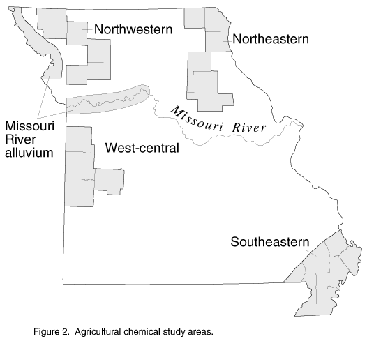
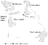
Ground water is used throughout Missouri as a source of drinking water.
The USGS, in cooperation with the Missouri Department of Health, collected
and analyzed water samples from 1986 to 1994 from 854 domestic wells and 36
springs to determine the occurrence and distribution of nitrate and
selected pesticides in ground water (fig. 2). The data from the study can
be used by State and local officials and citizens to make decisions about
how to mitigate the effects of agricultural chemicals on water supplies.
(Larger Version, 194K GIF)
|
|
Figure 2. Agricultural chemical study areas.
| |
Nitrate concentrations were detected in ground water much more frequently
and at much higher concentrations than were pesticide concentrations.
Based on the results of the study, as many as 84,000 domestic wells (24
percent) in the State may have nitrate concentrations greater than the U.S.
Environmental Protection Agency (USEPA) drinking-water criterion or may
have detectable concentrations of one or more pesticides. However,
elevated nitrate and pesticide concentrations in ground water were
significantly related to the source of the water, well depth, and water
level below land surface.
Water samples from wells that were less than 75 feet deep and where the
ground-water level was within 50 feet of the land surface had significantly
higher nitrate concentrations and were more prone to pesticide occurrence
than other samples. Water samples from wells that were less than 0.25 mile
from a feedlot and from wells where chemicals were mixed within 100 feet of
the well had significantly higher nitrate concentrations. Water samples
from wells where chemicals were mixed less than 100 feet from the well were
3.4 times as likely to have a pesticide occurrence than water from wells
where pesticides were mixed at distances greater than 0.25 mile from the
well. Water from wells susceptible to elevated pesticide concentrations
also had significantly higher nitrate concentrations. |
|
|
|
|
|
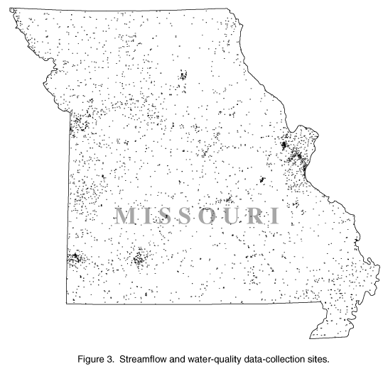
Several major rivers, including the Mississippi, the Missouri, the Osage,
the Current, the Meramec, the Spring, the Grand, and the Salt, supply water
not only to users within Missouri, but to several downstream States. The
USGS, in cooperation with more than 20 Federal, State, and local agencies,
collects streamflow or water-quality data or both at sites throughout the
State (fig. 3). These data are critical for day-to-day administration and
management of water resources, for determining the extent and severity of
droughts, for characterizing and predicting conditions during floods, and
for monitoring the effects of human activities on streamflow and water
quality. The data also are essential to interpretive studies that provide
information for making decisions about water issues that affect millions of
people. |

(Larger Version, 194K GIF)
|
|
Figure 3. Streamflow and water-quality data-collection sites.
|
|
|
|
|
After the floods that devastated the Midwest in 1993, scientists from the
USGS, the USEPA, the USACE, the Federal Emergency Management Agency, and
the National Oceanic and Atmospheric Administration joined in the
Scientific Assessment and Strategy Team High Resolution Digital Elevation
Model (DEM) project. This project is developing high-density DEM's for
about 2 million acres (3,400 square miles) along the Missouri and the
Mississippi Rivers. About 85 to 90 percent of the project area is within
Missouri. Improved hydraulic models can more accurately predict water flow
at river junctions, such as the Missouri, the Illinois, and the Ohio, where
flows and distributions are complex. The models can then be used for
simulating levee breaches and overtoppings, flood management and recovery
decisions, flow predictions, and flood prevention. |
|
|
|
The USGS ESIC provides information about the USGS, its programs, products,
and technological developments to users who are concerned with earth
science topics. The USGS Rolla-ESIC, located at the USGS office in Rolla,
offers nationwide information and sales service for USGS map products and
earth science publications and can fill orders for custom products, such as
aerial photographs, orthophotoquads, and map separates. The State ESIC,
also located in Rolla at the Missouri Department of Natural Resources,
Division of Geology and Land Survey (DGLS) office, was established under a
cooperative agreement between the USGS and the DGLS and has USGS map
products available for purchase for the entire State. As part of the
national ESIC network, these offices provide information on such topics as
cartography, geography, digital data, remote sensing, geology, geophysics,
geochemistry, hydrology, geohydrology, aerial photography, and land use.
The USGS provides each ESIC with reference materials, technical assistance,
training and outreach activities, and access to data bases. |
|
|
|
The USGS National Coal Resources Data System (NCRDS) provides data points
for compiling geologic maps of coal beds, determining the quality of coal,
and calculating coal resources and reserves. The USGS and the DGLS have
cooperated since 1979 to enter into the NCRDS about 6,500 data points from
drill holes and have measured stratigraphic sections to include in the
NCRDS. These data points consist of coal thickness, stratigraphic
information, and coal quality. In addition, coal croplines and mined areas
have been delineated. This program has included all major, active
coal-mining areas in Missouri.
|