|
|
The mission of the U.S. Geological Survey (USGS) is to provide geologic,
topographic, hydrologic, and biological information that contributes to
the wise management of the Nation's natural resources and promotes the
health, safety, and well-being of the people. This information consists of
maps, data bases, and descriptions and analyses of the water, biota,
energy, and mineral resources; land surface; underlying geologic structure;
and dynamic processes of the Earth.
|

|
|
|
|
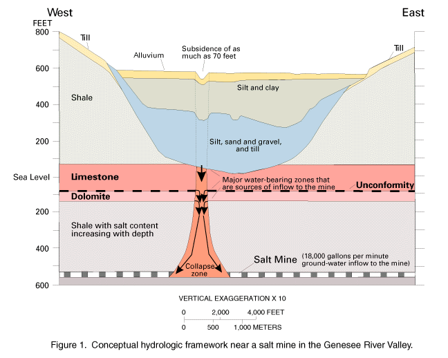
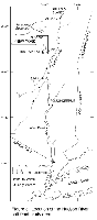
The USGS, in cooperation with the Livingston County Department of Health,
is assessing the effects of ground-water drainage into a collapse zone of a
salt mine on the regional aquifer system in the Genesee River Valley. The
salt mine, which had been in operation for 109 years, supplied road salt to
14 States in the Northeast. An underground room collapsed on March 12,
1994, and an adjacent room collapsed on April 18. Two large, circular
collapse features several hundred feet apart developed above them at land
surface. Fractures in the rocks above the mine transmitted ground water
(fig. 1) into the mine at a rate of about 18,000 gallons per minute. This
dewatered the aquifers above and adjacent to the mine. Consequently, some
water-supply wells have gone dry.
(Larger Version, 194K GIF)
|
|
Figure 1. Conceptual hydrologic framework near a salt
mine in the Genesee River Valley.
| |
The USGS has provided technical expertise in the assessment of land
subsidence in the area and has aided in maintaining a regional monitoring
network to record the rate of water-level declines. The New York State
Geological Survey installed a temporary earthquake-monitoring network to
detect sudden subsidence. The USGS also is developing computer models to
estimate the area affected by ground water that drains into the mine; to
predict the rate, extent, and magnitude of water-level declines; to
estimate the time needed for water levels in overlying aquifers to recover
to equilibrium conditions when mine flooding is complete; and to determine
the rate and extent of subsidence. |
|
|
|
Ground-water suppliers are implementing programs to protect recharge areas
from contamination. Although some methods of delineating contributing
areas to wells are inexact, more precise methods may not be cost effective.
The USGS is examining which methods are best applied to different
hydrologic conditions. One USGS study, in cooperation with the Suffolk
County Water Authority on Long Island, showed that a simple approach of
delineating circular recharge areas of unconfined aquifers gave better
results than more sophisticated and expensive methods. In contrast, a USGS
study in the Susquehanna River Basin, in cooperation with the New York
State Department of Environmental Conservation and the U.S. Environmental
Protection Agency (USEPA), showed that ground-water flow modeling might be
needed where the wells are close to rivers and streams. A third USGS study
showed contributing areas to wells screened in confined aquifers, such as
areas of the Magothy aquifer on Long Island, are large and diffuse, which
results in increased ground-water traveltimes and reduces the significance
of a parcel of land in protecting a deep well. |
|
|
|
|
|
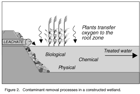
Nearly all landfills in humid areas produce leachate, which is the liquid
created when rainwater percolates through the layers of waste in a
landfill, and this leachate can contaminate ground and surface waters.
Modern landfills have bottom liners that catch the leachate and funnel it
to collection tanks. Ideally, leachate is processed on-site to minimize
the cost and risks of transporting it to a distant processor. The USGS, in
cooperation with Monroe County and the New York State Energy Research and
Development Authority, is investigating the use of constructed (artificial)
wetlands as a passive, inexpensive on-site method to treat landfill
leachate (fig. 2). This approach could significantly reduce the cost of
solid-waste management while reducing the threat to the landfill's
surroundings. |
(Larger Version, 194K GIF)
|
|
Figure 2. Contaminant removal processes in a constructed
wetland.
|
|
|
|
|
|
|
The USGS Biological Resources Division (formerly the National Biological
Service) conducts research and provides scientific data needed for
sustained economic benefits from and conservation of New York's terrestrial
and aquatic ecosystems. The Lake Ontario Biological Station, Great Lakes
Science Center, provides the critical information needed by resource
managers to restore native lake trout populations to Lake Ontario. Lake
trout disappeared from Lake Ontario in the mid-1900's. Stocking the lake
with hatchery-reared fish began in the 1970's. Studies are identifying the
trout most likely to reproduce and evaluating the effectiveness of sea
lamprey control; this exotic species is a major source of lake trout
mortality. Success has been demonstrated by the recent captures of
juvenile lake trout produced by mature hatchery fish that spawned in the
Lake. |
Economically important sport fishing for hatchery-reared trout and salmon
in Lake Ontario depends heavily on the productivity of forage fish
populations, which serve as food for the sport fish species. USGS
biologists focus on the population dynamics of alewives, rainbow smelt, and
slimy sculpins, which are the key forage species in the Lake. Studies
emphasize how changes in stocking rates and exotic species affect forage
fish populations.
Additional USGS studies include investigating fish losses in Lake Ontario
to predation by double-crested cormorants, evaluating the effects of zebra
mussels on native mussel populations, and providing data that can be used
to develop control strategies for zebra mussels. |
|
|
|
A large, continuous-type natural gas accumulation may exist in ancient
rocks in part of the Appalachian Basin in western New York and nearby
States. These sandstone gas reservoirs in the proposed continuous-type
accumulation are deeper and less permeable, contain less formation water,
and yield smaller quantities of gas per well than gas reservoirs in
discrete-type accumulations. However, the reservoirs in the
continuous-type accumulation are assumed to be saturated with gas and
nearly all wells drilled into them are expected to be productive after
hydrofracturing. The 1995 USGS National Assessment of U.S. Oil and Gas
Resources indicates that many trillions of cubic feet of gas may be
recoverable from the accumulation. Recognizing the great potential for
this energy resource, USGS scientists have begun a multiyear investigation
in New York and adjoining States to define the nature, size, and origin of
the accumulation. |
|
|
|
The USGS is cooperating with the Nassau County Department of Public Works
to delineate the subsurface hydrogeology and the extent of saltwater
intrusion along the northern shore of Long Island, which includes the Great
Neck Peninsula. Ground water is the sole source of drinking water for the
Peninsula, and four distinct wedge-shaped areas of saltwater intrusion have
been identified in Great Neck. These data provide water-resource managers
with better definition of the area's complex hydrogeologic framework and
the extent of saltwater intrusion. The data may be used to develop
water-supply pumping plans to minimize pumping stresses and to prevent
further intrusion of saltwater. |
|
|
|
|
|
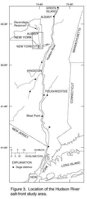
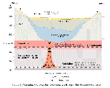
The 1995 drought in the Northeastern United States adversely affected water
suppliers throughout much of southern and eastern New York. Hard hit were
water suppliers that use the lower Hudson River as their water source. The
lower Hudson River between Albany and New York City is a tidal estuary
(fig. 3). Freshwater flows into the estuary from the Hudson River north
of Albany and from smaller rivers, and saltwater ebbs and flows into the
estuary from the south with the tidal cycle. The location of the interface
between fresh and salty water (salt front) is controlled by the quantity of
freshwater discharged into the estuary and the magnitude of ocean tides.
Monthly mean flows of the Hudson River near Albany in July and August 1995
were the third lowest in the last 50 years; only flows during the drought
in 1964 and 1965 were lower. The reduced freshwater inflow to the
Hudson River Estuary allowed the salt front to move as far upriver as the
city of Poughkeepsie, which uses the Hudson River for water supply. The
USGS has monitored salt-front locations and streamflow in the Hudson River
since 1989. During the 1995 drought, the USGS worked with the New York
State Department of Health (NYSDOH) to predict water releases from the
Sacandaga Reservoir that would prevent further upstream movement of the
salt front while minimizing adverse effects on the Reservoir. These
releases were successful in preventing further upstream movement of the
salt front. The USGS, in cooperation with NYSDOH, made 30 measurements of
the salt-front location in the Hudson River under drought conditions in
1995 that will improve the accuracy of predictions during future droughts.
|
(Larger Version, 194K GIF)
|
|
Figure 3. Location of the Hudson River salt-front study
area.
|
|
|
|
|
|
|
The USGS, in cooperation with the New York City Department of Environmental
Protection, is identifying the processes that control the chemical quality
of streams and rivers in the Catskill Mountains that are tributary to the
New York City reservoir system. Atmospheric deposition of nitrate is
greater in the Catskill region than anywhere else in the Northeast. Nitric
acid from precipitation increases the nitrate concentration in streams
during storms and snowmelt, causes acidification in streams, and increases
inorganic aluminum concentrations to levels that are toxic to fish. High
nitrate concentrations in streams could cause New York City water-resource
managers to consider stricter requirements on discharges from farms,
sewage-treatment plants, and other sources of nitrogen within Catskill
basins. One USGS study focuses on the mechanisms by which nitrate in soil
and ground water is transported to streams and reservoirs in the Catskill
Mountains and the effects of different logging practices on nitrogen uptake
and release in soil. Information on nitrogen processes and movement will
help define the transport of aluminum and nitrate and how management of
forests in reservoir basins can help control nitrate concentrations in
surface water. |
Calcium concentrations have decreased in forest soils in the Northeast
since the onset of acid deposition. Depletion of calcium, which is an
essential nutrient for tree growth, is linked to growth decline and dieback
of red spruce trees, which is occurring throughout the Northeast. A major
advance in knowledge of how acidic deposition reduces calcium
concentrations in soil occurred recently in a study by a USGS scientist,
who was working in collaboration with scientists from the U.S. Forest
Service, the University of Illinois, and Yale University. Results indicate
that acid deposition is increasing aluminum concentrations in the forest
floor and that displacement of calcium by aluminum on soil ion-exchange
sites is reducing the storage of calcium in soil. This reduction in the
soil's ability to store calcium in a form available to roots will make
restoration of calcium in soil difficult even if acid deposition is
decreased. |
|
|
|
|
|
In New York, the USGS has been experimenting with new methods to reach out
and inform the educational community and the public of the information
resources that the USGS provides. The USGS District Office in Troy held an
open house in fall 1995 with 12 technical demonstrations and more than 20
poster presentations. Tours were given to more than 160 junior high and
high school students. The USGS participates in the Hudson River Watch,
which is a program for middle and high school students in which they
monitor stream-water quality near their schools, by providing some funding
and technical advice and demonstrating sampling procedures. This program,
which is coordinated by River Watch Network, Inc., includes 21 schools
throughout much of the Hudson River Basin and has been extremely
successful.
The USGS also is funding the efforts of an educator from the Frost Valley
ymca to create an earth science curriculum by using USGS materials and to
distribute this curriculum to other ymca's nationwide. The USGS is
creating an Earth Science Resource Center at Hudson Valley Community
College from which earth science teachers can borrow teaching aids, such as
rock collections, hydrologic models, and instruments. Workshops are held
to familiarize teachers with the resources available. The USGS created the
Hudson River National Water-Quality Assessment Program Liaison Committee to
improve communication and coordination of the Hudson River assessment with
other government officials, researchers, and the public. A streamflow data
base is available on the Internet to provide current streamflow data for
the public and water professionals at:
http://wwwdnyalb.er.USGS.gov/htmls/pub/info.html |
The Earth Science Information Center (ESIC) in Albany was established under
a cooperative agreement between the USGS and the New York State Department
of Transportation Map Information Unit. As part of the national ESIC
network, this office provides information on such earth science topics as
cartography, geography, digital data, remote sensing, geology, geophysics,
geochemistry, hydrology, geohydrology, aerial photography, and land use.
It is supported by the USGS with reference materials, technical assistance,
training and outreach activities, and access to USGS data bases. |
|
|
|
|
|
A single agency can not provide all the personnel, expertise, or financial
resources needed to understand natural resources and the factors that
influence themŃa team approach is needed. The products of USGS projects
are generally the result of the cumulative efforts of many agencies and
individuals working independently and together to advance the understanding
of natural resources. |
For example, the USGS communicates frequently with the New York State
Geological Survey (NYSGS) and relies on its maps, data, and
interpretations. As part of this cooperation, the NYSGS is working with
the USGS's Mineral Resource Surveys Program to refine information on the
location and types of mineral deposits in New York and to develop new
approaches to working and evaluating these mineral resources. The NYSGS
maps surficial and bedrock geology, compiles mapping done by others, and
issues surficial and bedrock geology maps at various scales. In New York
State, the USGS Detailed Aquifer Mapping Project has made extensive use of
surficial and bedrock geologic maps provided by the NYSGS. Some of these
maps are based partly on records collected by the USGS, and the USGS has
provided part of the funding for some of these efforts. Currently, the
NYSGS is mapping the South Onondaga, Tully, and Otisco quadrangles in
Tulley Valley; this is a geologically active area in central New York State
in which mudboils occur and where the largest landslide in New York in the
last 75 years destroyed several houses in 1993. The NYSGS is receiving
some USGS funding from the statemap component of the National Cooperative
Geologic Mapping Program for this work and geologic mapping in the Mt.
Kisco quadrangle in Westchester County. |
|
|
|
|
|
The use of maps and digital cartographic data is widespread, and needs for
this information are expanding rapidly. The USGS, through its National
Mapping Program, strives to ensure the availability of map information in
graphic and digital forms to the general public through timely and
effective data-collection and revision procedures. Among the most popular
and versatile products of the USGS are its 1:24,000-scale topographic maps
(1 inch on the map represents 2,000 feet on the ground). These maps depict
natural and cultural features of the landscape, such as lakes and streams,
highways and railroads, boundaries, and geographic names. New York
encompasses 1,018 quadrangles mapped at this scale. These maps have long
been favorites with both the general public for outdoor uses, as well as
scientists and engineers for technical applications. |
As the lead agency for the National Aerial Photography Program (NAPP), the
USGS is cooperating with the USEPA to complete statewide color infrared
aerial photography coverage. The NAPP photographs are used to support many
environmental, land, and resource-management applications and also are used
to prepare digital orthophotoquads (DOQ'S). Planning is underway to use
this photography to produce color infrared DOQ'S statewide. The agencies
planning the doq project with the USGS are the nysdec, the U.S. Army Corps
of Engineers (USACE), the USEPA, the National Park Service, and the U.S.
Department of Agriculture, Natural Resources Conservation Service. |
|
|
|
|
|
The New YorkĐNew Jersey metropolitan area is the most populated coastal
region in the United States. The harbor estuary and offshore area are used
for waste disposal, transportation, recreation, and commercial fishing.
Bottom sediments in some areas have become contaminated as a result of
these activities over the last century, and environmentally acceptable
areas for disposal of dredged material from the harbor now need to be
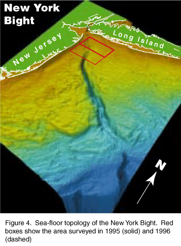
identified. The USGS is conducting a long-term multidisciplinary study to
map the distribution of contaminated sediments in the New YorkĐNew Jersey
region (fig. 4) and to develop a predictive capability for the transport
and long-term fate of sediments and contaminants. Federal, State, and
local agencies need this regional analysis of the sea-floor geology for the
management and wise use of the ocean near coastal areas, and scientists
need the information to plan and conduct research and monitoring. The
study is being conducted cooperatively with scientists at the Woods Hole
Oceanographic Institution, Rutgers Institute for Coastal and Marine
Science, the National Marine Fisheries Service, and the USACE.

(Larger Version, 194K GIF)
|
|
Figure 4. Sea-floor topology of the New York Bight. Red
boxes show the area surveyed in 1995 (solid) and 1996 (dashed)
| |
Long Island Sound is a major estuary in a heavily urban area adjacent to
New York Harbor. Sewage, wastes, and chemicals enter the Sound from
direct-waste discharges, river runoff, and the atmosphere and cause
widespread contamination of bottom sediments and loss of habitat for
bottom-dwelling (benthic) organisms. The USGS, in cooperation with the
USEPA, has initiated a multidisciplinary basinwide program to document the
sea-floor processes that control the distribution of benthic habitats and
sediment-related contaminants. The program, which uses unique USGS
capabilities in sea-floor imaging, contaminant-transport modeling, and
geochemical sampling, is basic to a wide range of environmental issues for
Long Island Sound, which, in turn, affect millions of people who use the
Sound each year for recreation and commerce.
|