|
|
For more than 100 years, the U.S. Geological Survey (USGS) has provided
the information needed to manage the Nation's earth resources, to mitigate
geologic hazards, and to understand the environment. In Ohio, the USGS
works cooperatively with local, State, and other Federal agencies, as well
as with universities, to study earth science.
|

|
|
Much of Ohio's social and economic development is determined by the
availability of usable water. Surface water is abundant in Ohio's streams
and lakes, which include parts of the Ohio River and Lake Erie. In
addition, unconsolidated aquifers (sand and gravel deposits) and
sedimentary bedrock aquifers (sandstone or dolomite deposits) throughout
Ohio provide a source of ground water. However, water quality is a
concern. Geologic processes, such as fracturing and mineral
concentrations, and human activities, such as agriculture, mining,
industry, and urbanization, affect water quality and the health and
well-being of the people, the economy, and the environment of Ohio.
Point-source contaminants of water can include organic substances from
sewage and industrial waste discharges and minerals from mining activities,
and nonpoint-source contaminants can include herbicides and fertilizers
used in agriculture and lawn care. |
|
|
|
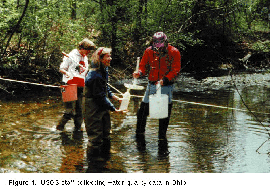
The USGS has collected and analyzed water-quality data in Ohio since 1946
to support national, State, and local water-resources managers in their
efforts to conserve, protect, and provide safe and usable water for the
public ( fig. 1). Partners in this effort
include the Ohio Department of Natural Resources (ODNR), and other Federal,
State, and local agencies.
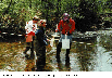
(Click on image for a larger version, 50K GIF)
|
|
Figure 1. USGS staff collecting water-quality data in
Ohio. | |
The USGS maintains and operates a monitoring network of ground- and
surface-water stations throughout Ohio to collect short- and long-term
water-quality data. The data from this monitoring network are made
available through computer data bases and as published reports and maps.
The USGS also provides "realtime" data as part of its monitoring network.
Realtime data allow the USGS and others to have immediate access to timely,
up-to-date information on water-quality conditions throughout the State. |
|
|
|
In 1991, the USGS began the National Water-Quality Assessment Program
(NAWQA) to describe the status and trends of large, representative parts of
the Nation's ground and surface waters and to identify and describe the
natural and human factors that affect their quality. USGS scientists are
studying the occurrence and distribution of pesticides, fertilizers,
sediment, and trace organic and inorganic contaminants by using data from
the USGS monitoring network and other agencies and academic institutions.
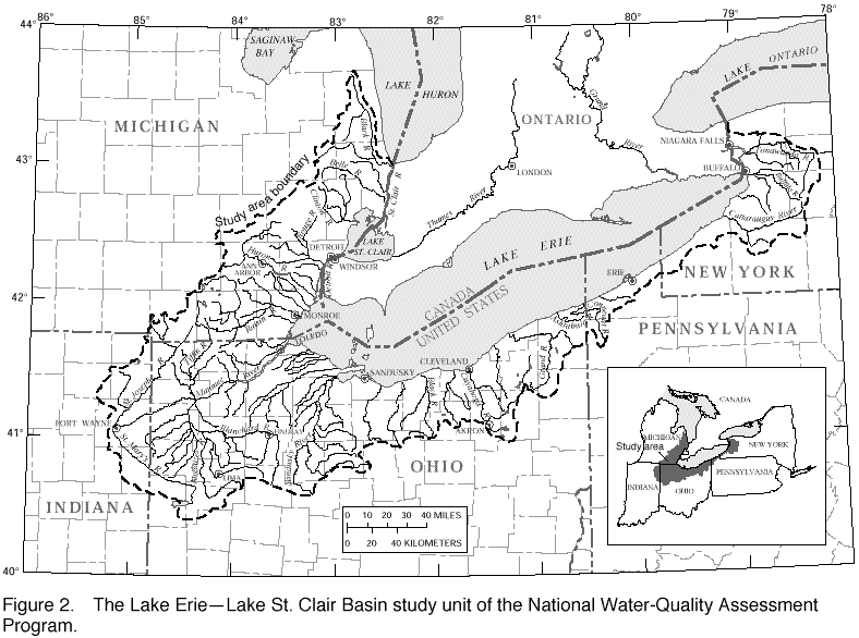
The Lake Erie-Lake St. Clair Basin study unit of NAWQA ( fig. 2) drains an area of about 22,300 square
miles that includes northern Ohio, southeastern Michigan, northeastern
Indiana, the northern tip of Pennsylvania, and southwestern New York.
Water resources in the study unit are central to the economy and culture of
the region. In 1988, the value of Lake Erie and its tributaries with
respect to sport fishing and related commerce was estimated to exceed $850
million.
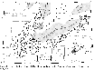
(Click on image for a larger version, 50K GIF)
|
|
Figure 2. The Lake Erie-Lake St. Clair Basin study unit
of the National Water-Quality Assessment Program. |
The study unit contains about 300 public recreational areas and about
90,000 acres of inland waters for public use. Lake Erie supports the
largest freshwater fishery in the Great Lakes (an estimated 50 million-60
million pounds of fish are caught per year) and is widely considered to be
the best walleye fishery in the world. Lakes Erie and St. Clair and the
St. Clair, the Detroit, and the Niagara Rivers are vital shipping links
that connect the upper Great Lakes to Lake Ontario and the St. Lawrence
Seaway. |
Although much progress has been made in the Lake Erie Basin to control
contamination and to improve water quality since the early 1970's,
water-quality managers often must regulate certain contaminants on the
basis of incomplete or conflicting information. More study is needed on
the following major water-quality issues in the Lake Erie-Lake St. Clair
Basin study unit:
- Reproductive impairment in fish and wildlife as a result of exposure to
and bioaccumulation of contaminants, such as PCB's, pesticides,
methyl-mercury, and other trace-element and trace-organic compounds.
- Elevated concentration of PCB's and other substances in fish tissue, which
affect the suitability of fish for human consumption.
- Decrease in water quality owing to the discharge of nutrients, pesticides,
trace elements, synthetic organic compounds, and pathogens to streams and
lakes by storm runoff.
- Declines in biological diversity of aquatic communities, which result from
habitat disturbance and alteration.
- Water-supply and ecosystem management problems caused by the proliferation
of nonnative species, such as the zebra mussel.
Communication and coordination between the USGS and other scientific and
water-management organizations are critical components of the NAWQA
Program. Each study-unit investigation has a local liaison committee that
consists of representatives of Federal, State, and local agencies;
universities; and the private sector. Each liaison committee exchanges
information on water-quality issues of regional and local interest,
identifies sources of data and information, assists in the design and scope
of project elements, and reviews project-planning documents and reports.
|
|
|
|
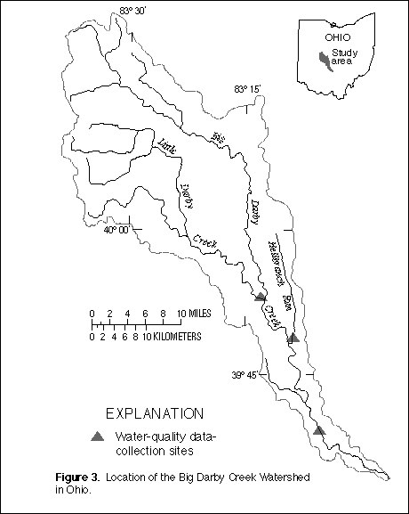
Big Darby and Little Darby Creeks have recently been designated National
Scenic Rivers because of their unusual diversity of fish (86 species) and
freshwater mussels (40 species). This watershed ( fig. 3) has received attention nationally as
one of The Nature Conservancy's Last Great Places, one of the Natural
Resources Conservation Service's Hydrologic Units, and one of the U.S.
Environmental Protection Agency's Ecological Risk Assessment Case Studies.
The USGS has been studying the washout and recolonization of algae and
macroinvertebrates in the Big Darby Creek Watershed to clarify how its
biological diversity is affected by the hydrology, water chemistry, and
physical disturbance associated with runoff during storms. During the
study, the USGS collected comprehensive data on sediments, nutrients, and
pesticides carried by storm runoff. Data and interpretive reports from the
study assist water-resources managers who oversee the watershed and benefit
residents of the watershed by providing insight into the probable
consequences of land-use practices in the Big Darby Creek Watershed. |

(Click on image for a larger version, 112K GIF)
|
|
Figure 3. Location of the Big Darby Creek Watershed in
Ohio. |
|
|
|
|
The lacustrine wetlands of Ohio, as well as other wetlands around the
Nation, have been greatly reduced in extent and function. The USGS, in
cooperation with the ODNR, and the U.S. Fish and Wildlife Service, is
actively involved in a restoration program for Metzger Marsh within the
Ottawa National Wildlife Refuge.
Wetlands act as a natural water filter and thus improve water quality, as
well as provide habitat for waterfowl and large and small mammals and serve
as nursery grounds for major lake fisheries. Increased development has
virtually eliminated fully functioning wetlands along the Ohio shoreline of
Lake Erie.
|
The Metzger Marsh restoration project represents a novel approach to
wetlands restoration that seeks to provide the widest possible range of
functionality. Follow-up monitoring will determine the success of this
project, which has the potential to provide a model for wetland restoration
projects throughout the Nation. |
|
|
|
Coal is used to produce about 20 to 25 percent of the total energy and more
than 50 percent of the electricity generated in the United States. Even
with substantial increases in energy conservation and the use of other
energy sources, coal will continue to be a major energy source into the
next century. In the National Coal Assessment, the USGS is working with
the ODNR to identify the location of coal resources, which include coal
potentially suitable for the export market, on public and private lands.
|
A key issue of interest to future coal users is the quality of coal that
will be mined in the next 20 years, particularly in the Appalachian Basin,
which includes southeastern Ohio. Investigators are compiling information
on the quality of various major coal beds. This information allows
planners and industry to identify areas that can sustain production of coal
of specific quality for various uses, which include clean coal combustion
and synfuel production.. |
|
The USGS, in cooperation with several Federal and State agencies, is
evaluating a beneficial use for the byproducts of scrubbers on coal-burning
powerplants that are designed to reduce sulfur emissions. Many tons of
scrubber byproducts are produced daily, and disposal costs are high. Use
of the byproducts in the reclamation of abandoned coal mines has been
proposed as a cost-effective and beneficial means of disposal. At a test
site in an abandoned mine in Tuscarawas County, the USGS is studying how
the application of scrubber byproduct affects the quality of ground water
beneath the site.. |
|
Important geologic mapping in Ohio is funded by the National Cooperative
Geologic Mapping Program. This statewide geologic mapping effort is
necessary to improve the definition of important resources, such as coal,
boiling gas, and ground water. The mapping also delineates areas that have
a high potential for indoor radon and zones of landsliding. |
|
|
|
The USGS strives to ensure that map and digital data are available to the
general public through timely and effective data-collection and revision
procedures. Among the most popular and versatile products of the USGS are
its 1:24,000-scale topographic quadrangle maps (1 inch on the map
represents 2,000 feet on the ground). These maps depict natural and
cultural features of the landscape, such as lakes and streams, highways and
railroads, boundaries, and geographic names. Ohio is covered by 788
quadrangle maps at this scale. These maps have long been favorites with
the general public for outdoor uses, as well as scientists and engineers
for technical applications.
|
The USGS has a cooperative agreement for digital map production with the
Ohio State University Center for Mapping (CFM). The USGS provides base
materials and other assistance to the CFM to support preparation of digital
line graph (DLG) data from 1:24,000-scale USGS topographic quadrangle maps.
DLG data layers that are being collected include the Public Land Survey
System, boundaries, hydrography, transportation routes, and contours. A
consortium of State agencies, which also supports this project, uses the
data for planning and resource-management applications and transportation
and utilities studies. The CFM has developed an innovative DLG production
scheme that uses "work-at-home" contractors to perform key production
functions. The CFM performs quality control, then sends the completed DLG
files to the USGS via the Internet for final review and public domain
archiving. Through 1995, this collaboration has resulted in DLG coverage
for more than 300 maps, or 40 percent of the State. |
|
|
|
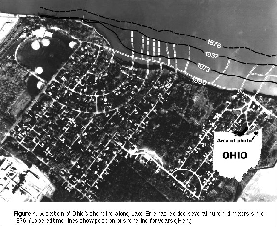
The shoreline along Lake Erie is eroding rapidly, which is resulting in
damage to public and private property. The USGS, working in cooperation
with the ODNR, is in the final year of a 5-year study to document historic
erosion of Ohio's shoreline bluffs ( fig. 4)
and to determine what natural processes and human activities are
contributing to the erosion of the shoreline. Because the Ohio shoreline
is similar to other eroding areas throughout the Nation, the results of
this study of erosion potential could have wide applications. Losses owing
to coastal erosion in Ohio exceed $40,000,000 per year. The research
conducted under this cooperative program enables prediction and mitigation
of this severe geologic hazard.
|

(Click on image for a larger version, 112K GIF)
|
|
Figure 4. A section of Ohio's shoreline along Lake Erie
has eroded several hundred meters since 1876. (Labeled time lines show
position of shoreline for years given.) |
|
|
|
|
The Cincinnati metropolitan area has one of the highest per capita costs of
landslide damage of any metropolitan area in the Nation. Landslides in
this area damage or destroy buildings, roads, and public utilities and cost
millions of dollars annually in lost productivity and repairs. USGS
scientists, in cooperation with the University of Cincinnati, have
identified some of the main causes of landslides and have helped lay the
technical groundwork for the landslide-mitigation efforts now underway.
Additionally, USGS scientists have developed a method to compare the
benefits and costs of programs designed to mitigate landslide damage. Use
of the method, which was developed in cooperation with the Federal
Emergency Management Agency, Hamilton County, and the city of Cincinnati,
identified a mitigation program that could produce annual benefits of $3.1
million at a cost of $1.4 million.
|
Nationally, the USGS National Landslide Information Center in Golden,
Colorado, is the focal point for collection and dissemination of
information on significant landslide events, critical research results, and
public policy issues that relate to landslides. The Center collects and
distributes a vast amount of information related to landslides to users
throughout the world. |
|
The USGS Earth Science Information Centers (ESIC) provide information to
the public about USGS programs, products, and technological developments.
The ESIC in Columbus was established under a cooperative agreement between
the USGS and the ODNR. As part of the national ESIC network, the ODNR
office provides information on aerial photography and remote-sensing data.
In addition, the USGS and the ODNR provide geological, geochemical,
geohydrologic, geophysical, and hydrological information to the general
public. The ODNR also serves as the contact point for USGS topographic
quadrangle maps for the State. |
|
|
|
As part of its outreach effort, the USGS participates in numerous
educational activities. For example, interested children from Millcreek
Elementary School (Perry County) and adults living in the Monday Creek
Watershed have been invited to help scientists write a new book for
children and teachers called "Hands-On Acidic Mine Drainage-Science
Experiments for Kids Living Where Creeks Are Red and Yellow." The Monday
Creek Watershed is one of many Ohio waterways affected by acid drainage
from mineral resources and abandoned mining operations. Creeks can be
colored red, yellow, and orange from the combination of acids and iron
precipitates. Children play in these creeks and are even known to use red
crayons when asked to draw pictures of waterways. Scientists from the
USGS, the U.S. Forest Service, the ODNR, and Ohio University have teamed up
with Rural Action's Monday Creek Restoration Program for this activity.
|
The USGS also participates in the Partners In Education Program with the
Grandview Heights School District (Franklin County). USGS personnel have
demonstrated and explained methods of collecting water-quality data to
students who represented the District's Middle School Science Olympiad
team. During the Spring Olympics (1995) for Ohio schools, the team placed
in the top five in the water-quality data-collection competition. |
|
|
|
USGS activities in Ohio are conducted in partnership with numerous Federal
and State agencies, local governments and organizations, and colleges and
universities. For example, water-resources studies in the State are funded
through a combination of Federal, State, and local government monies. More
than 50 percent of the 1995 water-resources studies were financed through
matching-fund agreements with State and local governments. The remaining
studies were funded through Federal sources, which include other Federal
agencies.
|
Another example of cooperative studies is a geologic mapping program by the
USGS and the ODNR to develop a new statewide bedrock map to replace the
existing 75-year-old one. As of August 1995, all 1:24,000
bedrock-quadrangle maps west of 82° longitude were available as open-file
editions at the ODNR. Full-color, 1:100,000-scale versions of three 30- x
60-minute quadrangles in western Ohio have been published. These new
geologic mapping products are popular with those engaged in mineral,
fossil-fuel, and ground-water exploration. |
|
|
|
The USGS Biological Resources Division (formerly the National Biological
Service) seeks to improve the understanding and management of exotic and
invasive species, commercial and recreational fisheries, and contaminants
in aquatic ecosystems in Ohio.
Studies are being conducted through the Great Lakes Science Center in
collaboration with the ODNR and others that focus on population dynamics of
walleye, yellow perch, lake trout, and other key predator, forage,
commercial, and recreational species and gathering important fish stock
data in the region. Biologists also are evaluating the effects of invasive
zebra mussels, ruffe, and sea lampreys in the Great Lakes and are
developing methods to stop the spread of these species. Other studies
include monitoring contaminants in aquatic ecosystems, restoration of diked
wetlands, and restoration of polluted watersheds affected by acidic mine
drainage.
|
The Ohio Cooperative Fish and Wildlife Research Unit, which is located on
the campus of The Ohio State University, is a cooperative effort supported
by the USGS. Unit scientists conduct research throughout the State on
fishery issues, habitat modification, bird community dynamics, and
endangered species in conjunction with State and Federal
agencies. |