This document is also available in pdf format: ![]() fs-035-99.pdf
fs-035-99.pdf
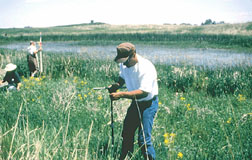
| Figure 1. Scientists collecting data on a restored prairie wetland. |
North Dakota prairies contain numerous wetlands. The complex functions of these prairie wetlands have been of interest for decades. The hydrology, water chemistry, and biological characteristics of these wetlands are highly variable because of extreme warm/cold and wet/dry conditions. The U.S. Geological Survey (USGS) has been conducting studies (fig. 1) to gain insight into the functions of the prairie wetlands. The USGS Northern Prairie Wildlife Research Center in Jamestown has maintained an active wetland research program since the mid-1960’s. Current work in North Dakota began in 1978, and focuses on the response of biological communities to climate-induced variations in hydrology and chemistry, and on evaluating the success of previously drained wetlands restored under the Conservation Reserve Program (CRP) and on similar lands. The information provided from this long-term study has provided the bulk of our knowledge about prairie wetlands, and has provided land managers with valuable information to manage the Nation’s prairie wetland resource.
Management of water resources also requires knowledge of the type and spatial distribution of wetlands, land-use, and runoff characteristics in a drainage basin. A study of restored prairie wetlands was designed to provide land managers with unbiased information about previously restored wetlands to foster the improvement of existing restoration technologies. The study is both multidisciplinary and multiagency; 24 collaborating organizations are involved in 23 separate investigations that span various topics. Another study was started to research the relations between wetlands and land use and the hydrology of the Red River of the North. Small-scale basins sites will be monitored, and hydrologic models will be developed to simulate the hydrology of the small-scale basins.
The USGS, in cooperation with the North Dakota State Water Commission, is demonstrating the use of high-resolution digital elevation data, geographic information systems (GIS), and surface-water runoff modeling software to define streamflow networks, to calculate surface-water storage capacity within low-relief landscapes, and to simulate precipitation runoff and storage.
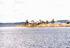
| Figure 2. Rebuilding North Dakota State Highway 57, which was flooded by Devils Lake. |
The Devils Lake Basin is a 3,810-square-mile drainage basin with no outlet to the ocean. About 3,320 square miles of the drainage area is tributary to Devils Lake. Lake levels were recorded sporadically from 1867 to 1901, when the USGS established a gaging station. The minimum recorded lake level was 1,400.9 feet above sea level in 1940. The maximum recorded lake level was 1,444.7 feet in July 1998. The previous maximum recorded lake level was 1,438 feet in 1867. In response to the rising water levels and extensive flooding in the Devils Lake Basin (fig. 2), Congress authorized the U.S. Army Corps of Engineers (USACE) to plan, engineer, and design an emergency outlet from Devils Lake. The proposed emergency outlet will consist of a pumping station and pipeline to remove water from West Bay of Devils Lake and discharge water into the Sheyenne River upstream from Warwick. The USACE needs to determine the potential effects of the outlet on downstream water quality, downstream reservoir operation, and future lake levels and water quality of Devils Lake. The USGS, in cooperation with the USACE, is studying the effects of a proposed outlet. One study is to simulate Devils Lake water levels and sulfate concentrations, and Sheyenne River discharges and sulfate concentrations just upstream and downstream from the proposed outlet. Another model for Devils Lake simulates future volumes and sulfate concentrations in response to future precipitation, evaporation, and inflow. A probability model is used to generate future values of precipitation, evaporation, and total inflow for Devils Lake. Another study is to evaluate the spatial and temporal variability of water quality in Devils Lake.
Landowners have expressed concern that additional discharges of water from the outlet to the Sheyenne River would lead to higher ground-water levels along the river that, in turn, would lead to less agricultural use of the land bordering the river. A study is being conducted to evaluate the interactions of the Sheyenne River and the local ground-water system adjacent to the Sheyenne River.
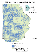
The USGS Energy Program’s National Coal Resource Assessment in North Dakota includes potentially minable Fort Union Formation coal in the Williston Basin. The Program’s objective is to assess the coal that will be mined and used in the next few decades. A digital database that will consist of the geography, stratigraphy, quality, and geochemistry of these coal zones is planned. The database is intended to be used to calculate the amount of available coal resources, evaluate the distribution, origin, and quality of the coal, and generate digital information. The Fort Union coal that is being assessed includes the Harmon-Hansen, Hagel, and Beulah-Zap coal zones. These coal deposits accounted for more than 3 percent of the total U.S. coal production in 1997. The coal from these coal zones contains small quantities of ash and sulfur and is a fuel used by many electricity producing power plants. The assessment is being done by the USGS in cooperation with the North Dakota Geological Survey, Bureau of Land Management (BLM), and four coal mines.
| Figure 3. Coal ownership in the Williston Basin. |
As U.S. Coal resources continue to be examined for potential development, a critical need exists for the assessment of federally owned coal resources. The coal assessments are intended to generate, store, and manipulate ownership and resource data in a digital format. A digital format allows the data to be analyzed efficiently using GIS, which combines data on coal quality, quantity, and depth with data on land- and mineral-management status. The USGS, in cooperation with the BLM, is collecting coal and other mineral-ownership data. The USGS has examined coal deposits in the Williston Basin of western North Dakota (fig. 3). High priority coal zones within the Fort Union Formation are being assessed, and resources are being reported according to surface and coal ownership and by such geologic characteristics as depth of overburden, coal thickness, and degree of geologic assurance.
The program is working closely with, and is providing information for, the National Coal Resources Assessment. The results of these projects are intended to help Congress and land-management agencies respond to complex questions regarding the quantity, quality, availability, and recoverability of federal coal.
Prairies are one of the most endangered ecosystems, and invasions of nonindigenous plants are a most insidious threat to native biodiversity. The same invasive species also threaten agricultural land and crops throughout North Dakota. The USGS is addressing the ecological implications of such invasions, developing tools that resource managers can use to optimize and prioritize weed-control efforts, and providing information about herbicide residues to State health authorities.
The USGS has found that leafy spurge pollen inhibits seed germination and growth among native flowering plants at Theodore Roosevelt National Park, and that native species diversity is significantly reduced in areas infested by dense weedy species such as leafy spurge and smooth brome. A new study has demonstrated that fire can be used to help establish flea beetles used for biological control of leafy spurge, and that established beetle colonies are not adversely affected by prescribed burns used to manage natural grasslands. A 5-year study initiated in 1998 is evaluating biological control of leafy spurge and Canada thistle on National Wildlife Refuges in North and South Dakota. A cooperative project at Theodore Roosevelt National Park seeks to develop a computerized ranking system for alien plant species infesting natural areas. The system is intended to help resource managers assess the threat of each species, and, thus, balance allocation of funds to control those species that are the greatest threat and have some likelihood of successfully being controlled.
Since 1989, the USGS has been investigating how birds use CRP fields in North Dakota and neighboring States. Early work focused on waterfowl, but, for the past 9 years, the whole range of bird species has been monitored. Landowners have graciously allowed the USGS to visit their land each year to record the number of each species found in each CRP field. Grassland habitats created by the CRP have proved to be a bonanza for many birds, including several species whose populations had declined in the past few decades. Research has identified how birds respond to different plantings, how populations vary from year-to-year and from one area to another, how bird populations respond to haying, and whether or not larger fields are proportionately more valuable habitat than smaller fields. Recent efforts are exploring how nearby habitats may influence the bird populations using CRP fields. The USGS studies were useful in designating much of North Dakota as a priority area for the CRP in the most recent farm bill, which enhanced the opportunities for North Dakota landowners who wished to enroll or reenlist their land in the program.
The USGS, in cooperation with about 30 Federal, State, and local agencies, operates an extensive hydrologic data-collection program. During 1998, data were collected at 157 streamflow and lake-level stations, 159 ground-water observation wells, 155 water-quality stations, and 2 atmospheric-deposition stations. Current-year data, which are published annually, are critical for the daily administration and management of water resources; for determination of the extent and severity of droughts; for characterization and prediction of conditions during floods; and for monitoring the effects of human activities on streamflow, ground water, and water quality. The data also are essential to interpretive studies that provide information about water issues that potentially affect all North Dakotans.
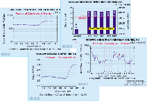
| Figure 4. Examples of realtime data available on a USGS World Wide Web page at http://nd.water.usgs.gov/. |
Realtime data for 71 streamflow stations, 7 river-stage stations, and 3 lake-stage stations, including selected stations in Canada and Minnesota, are being presented on the USGS computer in Bismarck. Realtime data can be accessed on the World Wide Web at http://nd.water.usgs.gov/. Streamflow and stage information for the last 7 days, current stage relative to recorded peak stages, and streamflow for the previous 18 months are provided in graphic form (fig. 4), along with information such as station location and length of record.
Record floods during the spring of 1997 devastated many communities along rivers in the Red River of the North and Missouri River Basins. The USGS works with other Federal, State, and local agencies to ensure that accurate and timely data are available for making decisions regarding the public’s welfare. Some of the post-1997 flood activities that the USGS is involved in are the development of consistent flood-frequency projections for the main stem of the Red River of the North using historical information, flood-hardening of many critical gages to assure availability of data during floods, upgrading of instrumentation at gaging stations, and increasing the number of sites capable of providing realtime data. The USGS also is participating in the International Joint Commission Red River Basin Task Force Study. Principal issues being addressed include the adoption of a consistent, common datum throughout the entire basin, including both the United States and Canada, and the development of accurate Digital Elevation Models (DEM’s) for flood-forecasting and planning models that are being developed or already are used by the National Weather Service and the USACE.
Among the most popular and versatile products of the USGS are its topographic maps at the scale of 1:24,000 (1 inch on the map represents 2,000 feet on the ground). North Dakota is covered by 1,464 of these maps, which have long been favorites with the general public for outdoor uses as well as technical applications in engineering and planning. These maps depict natural and cultural features of the landscape, such as lakes and streams, highways and railroads, boundaries, and geographic names.
The USGS has been working with Federal and State agencies to coordinate and produce standard products and digital cartographic data in North Dakota to meet a variety of needs. The availability of basic digital cartographic data, such as elevation, hydrologic, and transportation datasets, will allow for improved resource management and activities associated with GIS technology.
Among the most popular digital products produced by the USGS are Digital Orthophoto Quadrangles (DOQ’s). A DOQ is an aerial photograph that has been corrected for distortions and is stored as digital data. These digital images provide a snapshot of the Earth’s surface that has the accuracy of a topographic map, and are suited for use as base-maps on which other information can be overlaid.
Cooperation between Federal and State agencies has resulted in increased DOQ coverage of North Dakota. Numerous offices are using the digital images for natural-resource management and project planning. Recent agreements with communities such as Valley City, Dickinson, and Washburn have resulted in the production of DOQ’s for local planning. Larger programs with the Natural Resources Conservation Service are producing DOQ’s that can be used for digital soil mapping of counties.
Another USGS data product of growing interest in North Dakota is the DEM, which is a set of elevation values that cover the area of a 1:24,000-scale map. The DEM data have been useful for illustrating the Earth’s topography. The DEM’s can be used to derive characteristics such as slope from the elevation values. Several cooperative agreements have provided assistance in producing highly accurate DEM’s for drainage areas adjacent to Devils Lake.
The USGS is working with the North Dakota Geological Survey to complete statewide coverage of the Public Land Survey System (PLSS) in digital format. The PLSS datalayer references the rectangular township, range, and section delineation generally used to describe land parcels. These data will provide a base layer of information that can be combined with other features.
| Figure 5. Fifth-grade students playing the Water Jeopardy game. ("Jeopardy" is a registered trademark of Jeopardy Productions, Inc.) |
The USGS, the Turtle Mountain Band of Chippewa Indians, and the 5th-grade teachers on the Turtle Mountain Reservation cooperatively planned and conducted a water-resources program for the 5th-grade students. By stimulating interest and encouraging students to participate in the water-resources program, the USGS and Tribal employees hope to create a solid foundation for a lifetime of awareness and knowledge of their water resources that will benefit them and their community in thefuture. A water festival program was presented in 1997 and 1998 to about 375 5th-grade students (fig. 5).
|
The USGS has 103
|
USGS State Representative USGS Home Page: Reports and products: |
| AccessibilityFOIAPrivacyPolicies and Notices | |
 |
|