|
|
The mission of the U. S. Geological Survey (USGS) is to provide the
information needed to understand, manage, and use the Nation's natural
resources. Geologic, hydrologic and biologic data collected by the USGS
are used by other Federal, state, tribal, and local agencies and
individuals for a variety of purposes. USGS methods, techniques, computer
programs, and data are used widely. |

|
|
|
|
Major floods in Oklahoma have affected many people and have caused economic
damage and loss of life. Although floods cannot be prevented, information
furnished by the USGS is critical to the operation of flood-warning systems
and alerts. Information on the amount of water in reservoirs, river
stages, and the arrival of floodwaters helps people prepare for flooding,
thus lessening the destructive effects of floods.
Information furnished by the USGS to the National Weather Service Tulsa
River Forecast Center is used to predict maximum river heights and the
probable extent of flooding. Reservoir managers use the information, as
well as predictive models and past experience, to regulate incoming
floodwaters. Civil defense agencies use this information to warn people in
the pathway of the flood so they can avoid the worst of the flood or
protect their property against floodwaters. |
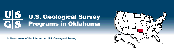
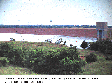
Record floods occurred on June 3, 1995, on the Elm Fork of the North Fork
Red River in southwestern Oklahoma (fig. 1). The USGS measured 60,000
cubic feet per second (cfs) of flow at the streamflow gaging station on the
State Highway 30 bridge. The 100-year flood for the Elm Fork at this site,
which is based on 20 years of record, is 29,800 cfs. The "100-year flood"
is a flood that has a chance of 1 in 100 of occurring in any year. The
mean annual discharge for the Elm Fork is 42 cfs. The previous record
flood was 22,100 cfs on May 17, 1977.

(Larger Version, 291K GIF)
|
|
Figure 1. Left, August 24, 1994, during base-flow
conditions at the Elm Fork of the North Fork Red River near Carl, Oklahoma.
Right, June 3, 1995, near the peak of record flow of 62,300 cubic feet per
second.
| |
|
|
|
The Red River near Gainesville, Texas, was at flood stage at 7:30 a.m. on
June 9, 1995. The USGS measured 155,800 cfs of flow at the streamflow
gaging station on the Interstate Highway 35 bridge, which is 31 miles
south of Ardmore, Oklahoma. The 100-year flood for the Red River at this
site, which is based on 46 years of record, is 189,000 cfs. The mean
annual discharge for the Red River at Gainesville is 3,227 cfs. The
record flood is 256,000 cfs on May 31, 1987.
After flooding has passed, the USGS, in cooperation with Federal, State,
tribal, and local agencies, studies the extent of the flooding and the
weather patterns and rainfall intensity that led to the flooding. As an
important part of its fact-finding efforts, the USGS evaluates and maps the
extent of flooding and attempts to determine how often floods of that
magnitude may be expected to recur. The USGS also maps the movement of
streambanks caused by powerful floodwaters. Bridges may be washed out or
their piers undermined by swiftly flowing water. By using computer models,
a prediction can be made of conditions that might weaken or threaten a
structure so that preventive steps can be taken by the appropriate agency
to lessen the hazard. |
In addition to studying the effects of flooding, the USGS has prepared maps
that show the probable extent of flooding for many urban areas throughout
Oklahoma. Maps of these flood-prone areas, which show the approximate
boundaries of the 100-year floods, are used extensively to plan locations
of homes, offices, and industries. Studies of specific communities or
localities for use in planning and community development are made by the
USGS in cooperation with the Federal Emergency Management Agency.
The USGS also provides information on how often a flood that inundates a
specific area may be expected to happen again in any year. This
information is useful in designing flood-control structures, such as dams,
retarding structures, holding ponds, and spillways. Although flooding may
be expected for specific areas, information on the frequency of flooding
can aid community planners in flood-plain development. Long-term
monitoring of streamflow and flood flows provide the data needed for
statistical analyses of floods and the prediction of future flooding. |
|
|
|
|
|
Accurate knowledge of the quantity and quality of surface- and ground-water
resources is vital to the citizens of Oklahoma. The state depends on
information gathered by the USGS and the Oklahoma Water Resources Board and
on interpretations of these data to determine water rights.
Continuous measurements of flow are needed by those who manage
surface-water supplies. The determination of the amount of surface-water
flow in Oklahoma is of great importance to the irrigators of the State,
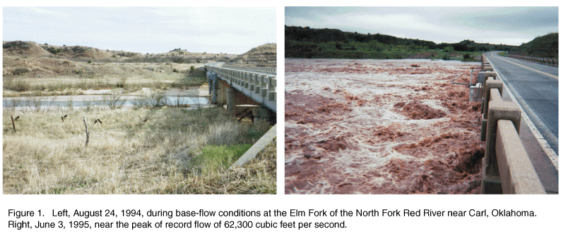
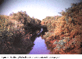
particularly in western Oklahoma. In central and eastern Oklahoma, surface
water is used by many communities as the primary source of public water
supply (fig. 2). |
(Larger Version, 291K GIF)
|
|
Figure 2. Lake Arcadia Reservoir supplies drinking water
and recreation for the Oklahoma City metropolitan area.
|
One of the principal continuing duties of the USGS throughout the United
States is the measurement of flow in the Nation's rivers and streams. In
Oklahoma, the USGS maintains an extensive network of about 150 streamflow
monitoring stations. Many of these stations transmit data by satellite;
these data are valuable in flood monitoring and prediction. Daily flow
values from all Oklahoma stations are published yearly. |
|
|
|
The USGS, in cooperation with the Oklahoma Water Resources Board, monitors
water levels in key wells throughout the State. Water levels in other
wells are measured in conjunction with specific projects and many
additional wells are measured annually by the Oklahoma Water Resources
Board.
The USGS, in cooperation with State and local agencies, has completed
appraisals of ground-water availability and quality in many areas of
Oklahoma. Many of the aquifers in the state have been studied by using a
USGS-developed ground-water flow model. For instance, the model predicted
water-level changes in the Antlers aquifer in southeastern Oklahoma in
response to various hypothetical pumping rates at 10-year increments for
several decades into the next century. |
A ground-water flow model also was developed to study the alluvial and
terrace deposits associated with the Cimarron River in northwestern
Oklahoma. The aquifer is well connected to the Cimarron River, and has an
average saturated thickness of 28 feet with an estimated 4.47 million
acre-feet of water in storage. The model will be useful to the Oklahoma
Water Resources Board in managing the ground-water resources of the area.
A similar model recently was developed for the Blaine aquifer in
southwestern Oklahoma and northwestern Texas.
The Arbuckle-Simpson aquifer, in south-central Oklahoma, has been the focus
of several recent studies conducted by the USGS in cooperation with Federal
and state agencies and the city of Ada. A multiday aquifer stress test
evaluated the effects of municipal ground-water withdrawals on the
hydrologic system. Simultaneous pumping of two municipal wells for 241
hours at a combined average rate of 3,900 gallons per minute resulted in a
maximum observed drawdown of 1.3 feet, recorded at an average distance of
1.1 miles from the pumped wells. Geophysical and geochemical data have
been collected in an effort to understand ground-water flow in this
aquifer. |
|
|
|
|
|
The National Cooperative Geologic Mapping Act became law in 1992. The Act
was the result of a collaborative effort by the USGS and the Association of
American State Geologists to develop statemap, a program to accelerate the
detailed geologic mapping in areas of critical need in the United States.
Through the state mapping component of the Act, matching Federal funds are
made available to states to develop geologic-map coverage of priority
areas. |
This program, and its predecessor effort, cogeomap, have produced detailed
geologic mapping of 24 quadrangles in the Ouachita Mountains of
southeastern Oklahoma. These quadrangle maps are available from the
Oklahoma Geological Survey. With the printing of the Savanna and the
McAlester geologic quadrangle maps, a six-map block in the McAlester area
will be completed. In addition, the 1996-97 program initiated the
development of digital geologic maps at a scale of 1:100,000. |
|
|
|
Among the most popular and versatile products of the USGS are its
1:24,000-scale topographic maps (1 inch on the map represents 2,000 feet on
the ground). About 1,240 maps cover Oklahoma. These maps have long been
favorites with the general public for outdoor uses, including hiking,
camping, exploring, and back-country fishing expeditions. |
|
|
|
|
|
The USGS, in cooperation with the Oklahoma Department of Transportation
(OkDOT), is producing updated digital line graphs (DLG's) to be used for
development, planning, and management decisions relevant to the
transportation network in Oklahoma. The USGS and the OkDOT also are
cooperatively funding statewide coverage of digital raster graphics
products in Oklahoma. The USGS, in cooperation with Oklahoma State
University's Department of Agronomy, is jointly producing digital elevation
models (DEM's) that can be used with hydrologic data for modeling water
flow, inundation studies, and hydrologic planning and management decisions. |
The USGS and the Oklahoma Water Resources Board jointly produced
1:24,000-scale hydrography Digital Line Graphs (DLG's). These DLG's can be
used with DEM data for watershed delineation and hydrologic planning and
management decisions by Federal, State, Tribal and local agencies. |
|
|
|
|
|
The cooperative production and sharing of geospatial data provides cost
savings for cooperating agencies at every level of government, increases
the amount of data available, and reduces duplication of data production
efforts. |
The USGS, in cooperation with the Oklahoma Sate University Environmental
Institute, the Oklahoma GIS Council, and the Oklahoma State Geographer, is
developing an interactive geographic information system for the State. The
objective is to provide a centralized source for searching, evaluating, and
accessing geospatial data sets. The two principal efforts are to create an
inventory and to record and catalog metadata in accordance with the Content
Standards for Digital Geospatial Metadata and to establish and maintain a
node on the National Geospatial Data Clearinghouse. |
|
|
|
The Earth Science Information Centers (ESIC's) provide information about
USGS programs, products, and technological developments to the public. The
ESIC in Norman was established under a cooperative agreement between the
USGS and the Geology Library at the University of Oklahoma. As part of the
national ESIC network, this office provides information on such
earth-science topics as cartography, geography, digital data, remote
sensing, geology, geophysics, geochemistry, hydrology, geohydrology, aerial
photography and land use. It is supported by the USGS with reference
materials, technical assistance, training and outreach activities, and
access to USGS data bases. |
|
|
|
|
|
The USGS Biological Resources Division (formerly the National Biological
Service) conducts research and provides the scientific data needed for
sustained economic benefits from, and conservation of, the grassland
ecosystems of the Great Plains. USGS research activities include studying
the biology, status, and habitat requirements of endangered fish, such as
the leopard darter, the Arkansas darter, and the speckled chub; documenting
the wildlife values of the Conservation Reserve Program, which removed
about 36 million acres of marginal farmland from agricultural production
nationwide and enhanced its value for wildlife; and collecting biological
information in the Ozark Plateau as part of the National Water-Quality
Assessment Program. |
The Oklahoma Cooperative Fish and Wildlife Research Unit, located at
Oklahoma State University, conducts research on smallmouth and striped bass
in the eastern part of the state, where they are an important recreational
resource, and is participating in the Gap Analysis Program to improve
access to the state's biological resources. |
|
|
|
|
|
Contamination of our surface-water and ground-water resources is one of the
most pressing issues in the management of the Nation's natural resources.
The USGS has sampled the rivers, wells, and springs at about 25,000 sites
in Oklahoma. These samples have been analyzed for a broad range of
inorganic and organic substances, which includes pesticides and herbicides,
that might affect the suitability of the water for human consumption or
nonconsumptive use. Results of chemical analyses of ground-water samples
generally are published at the end of a project; results of surface-water
analyses are published annually.
The USGS is investigating possible ground- and surface-water contamination
at many sites. At Altus Air Force Base in southwestern Oklahoma, the USGS
is studying possible ground-water contamination that results from past use
of solvents and cleaning solutions for aircraft maintenance and repair
activities at the air base. Information on the presence and concentration
of contaminants on Federal lands, such as Altus Air Force Base, is useful
to determine the necessity for remediation of the contamination. The USGS
has just completed a study of water quality and water movement within the
aquifer underlying central Oklahoma. Determination of natural movement and
chemical change within the aquifer was a primary objective of the project.
The study indicated that most of the aquifer is uncontaminated and that
further development of the aquifer for drinking water is possible. The
USGS, in cooperation with the city of Norman, is studying the processes
that control movement of possible contaminants within and from an old
landfill near Norman. |
Rural residents in western Oklahoma use ground water primarily for
household use. The USGS recently compiled data for nitrogen and phosphorus
concentrations in water from these aquifers. The results can be used to
set priorities for ground-water protection.
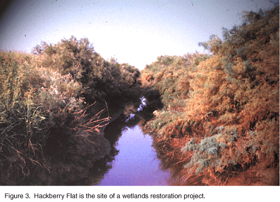
Alteration of land use in Hackberry Flat (fig. 3), a wetlands restoration
project in southwestern Oklahoma, operated by the Oklahoma Department of
Wildlife Conservation (ODWC), could mobilize natural elements and manmade
organic compounds that are in the soils. The USGS, in cooperation with the
ODWC, is establishing base-line environmental conditions at Hackberry Flat
on the basis of analysis of 182 soil samples. The results of this study
will help the ODWC evaluate environmental factors that affect migrating
waterfowl at the wetlands restoration site.
(Larger Version, 291K GIF)
|
|
Figure 3. Hackberry Flat is the site of a wetlands
restoration project.
| |
|
|
|
The State of Oklahoma regulates the discharge of pollutants to streams so
that streams do not exceed a permissible limit for pollutants. To set a
limit on the effluent discharge concentration, the chemical content and
flow of the effluent-receiving streams must be known. Data collected,
analyzed, recorded, and distributed by the USGS help state agencies
determine the values used in issuing discharge permits. |
Data collected by the USGS can help regulatory agencies maintain and
improve the chemical quality of water in aquifers and streams within
Oklahoma by providing base-line data against which changes may be compared
and evaluated. Agencies rely on data furnished by the USGS to design
protection strategies for water use. Evaluation of water-quality
information will help water users realize the full potential of the use of
water�how, for what, and in what quantities it might be used and the
possible effects of using the water.
Determination of water quality in Oklahoma's lakes, streams, and aquifers
has become increasingly important with population growth and need for
usable water. The USGS has collected extensive data on water quality
within Oklahoma for use by cooperators. |
|
|
|
|
|
The USGS, as part of the ongoing National Oil and Gas Assessment Project,
completed and released the 1995 National Assessment of United States Oil
and Gas Resources in early 1995. The assessment was released on CD-ROM as
U.S. Geological Survey Digital Data Series DDS-30. This CD-ROM, which can
be viewed on many types of personal computers, contains maps and text for
the U.S. provinces and plays included in the assessment, a discussion of
the methods used, and the results. The maps show drilling intensity and
locations and types of petroleum production for individual plays. Oklahoma
holds a significant position in U.S. petroleum production because a large
part has come from the Anadarko Basin Province, most of which lies in
Oklahoma. Production from the Province was assigned to 25 individual
plays. Deeper, less well explored parts of the province may contain
significant quantities of undiscovered natural gas. |
A series of map sheets show drilling intensity, petroleum producing wells
locations of major fields used in the assessment, drilling depths to the
top of major producing units, and tabular data for the major fields for the
Anadarko Basin Province. The first three sheets of this series--covering
the Arbuckle, Simpson, and the Viola Groups--have been completed.
|