

| |
|
This is a collaborative program to facilitate basin-scale water and environmental resource management by coupling watershed models that describe the physical hydrologic setting, routing and reservoir management models that account for downstream water use, and reach-specific hydraulic and biogeochemical models conditioned on upstream streamflow.
Competition among water-resource users in many basins in the western United States has resulted in a need for near real-time assessments of water availability and use. The use of coupled hydrologic and water-management models can provide these assessments, with substantial benefits for water- resource planning and operation. Advancements in computer hardware and modeling software have enabled the development of such water-resource models.
The U.S. Geological Survey (USGS) and the Bureau of Reclamation (Reclamation) are working collaboratively on a long-term project, termed the Watershed and River Systems Management Program (WARSMP). The goal of the program is to couple watershed and river-reach models that simulate the physical hydrologic setting with routing and reservoir management models that account for water availability and use. The coupled models are to be applied to Reclamation projects in the western United States. The program also supports the development of the models and necessary software tools for coupling and use of the models.
The key to coupling these models is linking them through a common database, the hydrologic database (HDB). The coupling provides a database-centered decision support system (DSS) where output from one model can be written to the database for use as input to another model (fig. 1). The HDB also links ancillary tools needed by individual models, such as a geographic information system (GIS), statistical analysis, and data query and display capabilities.
 |
|
Figure 1. Database-centered decision support
system (DSS).
|
The GIS provides an automated method to define values for distributed model parameters, provides animation tools to visualize and analyze the spatial and temporal distribution of simulated hydrologic variables, and allows comparisons of these variables with independent measures of their spatial and temporal variation. Thus, the DSS allows for improved assessments of long-term planning and policy decisions, in addition to the major thrust of improving short-term and mid-term operations, scheduling, and planning decisions.
The initial application of the WARSMP was in the 23,000 mi2 San Juan River Basin in Arizona, Colorado, New Mexico, and Utah, a major tributary to the Colorado River. Beginning in fiscal year 1997, the focus of the WARSMP has been the application of the DSS to the Yakima River Basin located in eastern Washington (fig.2). The basin has a drainage area of about 6,200 mi2 and produces a mean annual unregulated runoff of about 5,600 ft 3/s (about 4,055,000 acre-feet) and a regulated runoff of about 3,600 ft 3/s. There are eight major tributary rivers and numerous smaller tributary streams.
The headwaters are on the humid east slope of the Cascade Range, where mean annual precipitation is more than 90 inches. The basin ends where the river discharges to the Columbia River in the low-lying, arid part of the basin that receives about 6 inches of precipitation per year. Most of the precipitation falls during the winter, and occurs as snow in the mountains. Total mean annual precipitation in the basin is about 27 inches (about 12,000 ft 3/s or 8.7 million acre-feet).
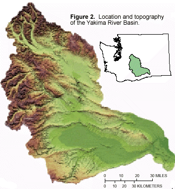
The topography is highly varied (fig. 2) and parallels the spatial pattern of mean annual precipitation.
Altitudes in the basin range from 400 to nearly 8,000 feet. Agriculture is the principal economic activity in the basin, followed by recreation and timber use. The average annual water demand is about 2,500,000 acre-feet, or nearly 65 percent of the mean annual unregulated flow. Most of the demand is for irrigation of about 500,000 acres in the low-lying semiarid to arid parts of the basin. The demand is met by storage of water in five major reservoirs that can store 1,065,000 acre-feet or about 26 percent of the mean annual natural flow of the river. The basin has more than 80 canals, 5 diversion dams, and 15 major return flows. Nearly 45 percent of the water diverted for irrigation is eventually returned, at varying time-lags and as both surface and ground water, to the river system. During the low-flow period, these return flows account for about 75 percent of the water in the lower river system.
The headwater drainages are the sources of water, and the major water uses occur downstream in the drier parts of the basin. Thus, the variability in topography, climate, and water use creates long distances between supply and demand, which in turn results in spatial and temporal variations in the quantity and quality of streamflow throughout the basin.
Issues of many western States are common to the basin. These issues include Indian treaty rights, historical water rights, over-appropriation of water, reservoir and irrigation development, increasing demand for wildlife and anadromous and resident fish, water quality of the streams and ground water, and the interaction of ground water and streamflow. New demands are being met by ground-water sources and compound the issues. Judicial law also affects water-management in the basin, and will continue to do so.
The USGS Modular Modeling System (MMS) is being used for the watershed modeling component of this study. MMS is an integrated system of computer software developed to provide a framework for the development and application of models to simulate a variety of water, energy, and biogeochemical processes (Leavesley and others, 1996). MMS has three major components: pre-process, model, and post-process (fig.3). The pre-process component includes tools used to input, analyze, and prepare spatial and time-series data for use in model applications.
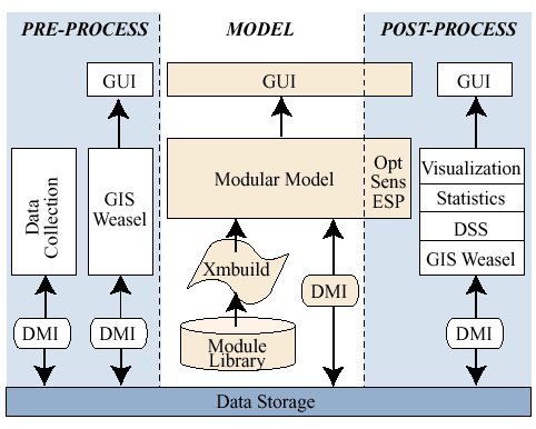 |
| Figure 3. Schematic diagram of the components of the Modular Modeling System (MMS). |
The model component includes tools to develop and apply models. The post-process component provides tools to display and analyze model results, and to pass results to management models or other types of software such as the HDB. All three components include graphical user interfaces (GUIs) and data-management interfaces (DMIs). A major feature of the model component is the module library that contains a variety of modules for simulating water, energy, chemical, and biological processes. The user, through an interactive model builder interface (xmbuild), selects and links modules to create a specific model.
A GIS interface, termed the GIS Weasel (Leavesley and others, 1997), is part of MMS. The Weasel facilitates model development, and also can be used as a watershed analysis tool. A digital elevation model for the basin provided the input to Weasel for automatic delineation of the basin and for delineation of subbasins to be modeled or analyzed. Based on locations of streamflow sites, stream locations at mouths of ungaged watersheds, and water-management points, 59 subbasins were defined (fig. 4).
The models being constructed for the non-agricultural subbasins allow for the spatial distribution of hydrologic parameters by partitioning or characterizing a subbasin into modeling response units—MRUs (Leavesley and others, 1983). MRUs (formerly called hydrologic response units) are assumed to be homogeneous in their hydrologic response. The Weasel provides a menu for examining and modifying the MRU boundaries for a subbasin; as part of the examination process, any attribute currently residing in the GIS for a MRU is provided.

Data derived from the original digital elevation model (for example, slope, aspect) and other gridded attribute data (for example, vegetation, soil depth) can be used to estimate selected MRU and subbasin parameters. MRUs were characterized using the Weasel, based on information about landscape characteristics, precipitation, and soil characteristics. Initial characterization of subbasins resulted in about 1,000 MRUs.
Within the modeling process, a daily water balance is computed for each MRU on the basis of climate inputs (daily values of air temperature, precipitation, and solar radiation) and model parameters. The responses of all MRUs are summed on a input into the HDB for use by the river and reservoir management model component of the DSS, the RiverWare system. The RiverWare system is being applied by Reclamation's analysts.
The RiverWare System is the river and reservoir management model being used in the San Juan and Yakima River Basins (fig. 5). RiverWare is a general-purpose, interactive model-building tool used to develop water-distribution models for short-term operations and scheduling, mid-term operations, and planning. The modeling framework was developed by the Center for Advanced Decision Support for Water and Environment Systems (CADSWES) at the University of Colorado with funding provided by Reclamation, Tennessee Valley Authority (TVA), and Electric Power and Research Institute (EPRI) (Fulp and others, 1995).
Within RiverWare, the user constructs the basic network of a river system that may include reservoirs, diversions, river reaches, confluences, or other components. Data associated with each component can be entered on-screen through spread sheets or imported from the database. The operations policy and rules associated with reservoirs or other system components within the basin are added to RiverWare through an existing constraint editor. Current modeling methods within RiverWare include basic reservoir simulation and water distribution through the network using linear programming, goal programming, and rule-based simulation approaches. As part of the Yakima River Basin WARSMP, water-rights allocation is being developed as an additional modeling method. Hourly, daily, weekly, and monthly computational time steps are supported.
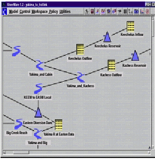 |
| Figure 5. Computer screen showing model layout of RiverWare for the upper Yakima River, showing two reservoirs, a diversion dam, inflows, outflows, and six reasches. |
Linking of models in the DSS provides a way to examine water- resource problems at reach and cross section scales using streamflow that reflects basin-wide water resources. Many water-management issues, such as fisheries and water-fowl habitat, water-quality concerns, and channel maintenance for river recreation, need reach-specific hydraulic and chemical information, conditioned on upstream streamflow. That is, the detailed hydrology of a given reach must include the constraints of the overall physical hydrology and water-management within the basin.
One way to include these constraints is to use reach-specific models within the modeling sequence. Several reach-specific models are included in MMS and can be linked with the watershed model or RiverWare output. For example, a one-dimensional hydraulic model using daily streamflow from RiverWare, along with detailed local topography and bed material information, can be used to predict a stage-discharge relation, reach-averaged vertical distributions of velocity, and stress at a cross section (Nelson and others, 1991). These relations provide the necessary hydraulic input to compute bed sediment discharge (Parker and others, 1992). Identifying sediment discharge and associated hydraulic conditions, and predicting changes that occur with alterations in the hydrograph, are critical to an understanding of channel and habitat maintenance.
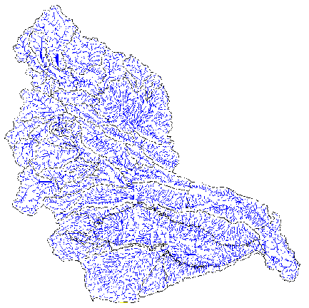
A linkage being examined for the the Yakima River Basin is the use of river-reach habitat characteristics in MMS and linkage of them to RiverWare. For this work, the relation between stream networks and the upstream area, slope, precipitation, runoff, forest density, and land use will be analyzed. For this effort, a stream network was defined using the GIS Weasel based on the digital elevation model. A stream channel was defined wherever the drainage area was greater than 0.47 mi resulting in a detailed network (fig. 6). This network of more than 7,000 miles will then be examined for relations to the basin characteristics, stream-slope (gradient), width, and flood-plain extent. If the results prove promising, the information may be used to develop habitat-type curves for a MMS module and linkage to RiverWare.
 |
|
Figure 6. The stream network defined
for the Yakima River Basin using the GIS Weasel.
|
Continued work in the WARSMP will be in the Yakima River Basin and the Rio Grande Basin, New Mexico. The goal of each new project is to develop additional algorithms to the MMS and the RiverWare system in order to help solve additional water-resource problems, especially related to biologic problems and needs.
Fulp, T.J., Vickers, W.B., Williams, B., and King, D.L., 1995, Decision support for water resources management in the Colorado River region: in L. Ahuja, J. Leppert, K. Rojas, and E. Seely (eds.), Workshop on Computer Applications in Water Management, Colorado Water Resources Research Institute, Fort Collins, CO., Information Series no. 79, p. 24-27.
Leavesley, G.H., Lichty, R.W., Troutman, B.M., and Saindon, L.G., 1983, Precipita- tion-runoff modeling system—users manual: U.S. Geological Survey Water-Resources Investigations Report 83-4238, 207 p.
Leavesley, G.H., Restrepo, P.J.,Markstrom, S.L., Dixon, M., and Stannard, L.G., 1996, The modular modeling system (MMS)—user’s manual: U.S. Geological Survey Open-File Report 96-151, 142 p.
Leavesley, G.H., Viger, R.J., Markstrom, S.L.,and Brewer, M.S., 1997, A modular approach to integrating environmental modeling and GIS: in Proceedings of 15th IMACS World Congress on Scientific Computation, Modelling, and Applied Mathematics, Berlin, Germany.
Nelson, J.M., Emmett, W.W., and Smith, J.D., 1991, Flow and sediment transport in rough channels: in Shou-Shen Fan and Yung-Huang Kuo, eds., Proceedings of the Fifth Federal Interagency Sedimentation Conference, v. 1, p. 4-55 to 4-62.
Parker, R.S., Nelson, J.M., Elliott, J.G., and Carey, W.P., 1992, Changes in bed mobility due to altered streamflows in cobble-bedded mountain streams in the Gunnison River basin: EOS, Transaction of American Geophysical Union, v. 73, no. 43, p.239.
World Wide Web sites:
http://wwwbrr.cr.usgs.gov/mms| AccessibilityFOIAPrivacyPolicies and Notices | |
 |
|