This document is also available in pdf format:
![]() fs-037-99.pdf
fs-037-99.pdf
Oklahoma has experienced several periods of drought since statehood, some lasting several years. Major droughts in Oklahoma occurred in 1929-41, 1951-57, 1961-72, and 1975-82. A significant but more localized drought occurred during 1984-86. The most recent short-term droughts have occurred during 1995-96 and 1998.
A severe drought began about April 1998 in southern and western areas of Oklahoma. From April 1, 1998, to January 10, 1999, southwestern Oklahoma received only 55 percent of the normal rainfall. Rains during September 1998 helped many areas, but several lakes in the south remained low into the winter. In January 1999, southwestern Oklahoma continued in a moderate drought; fifteen reservoirs still were operating at less than full capacity. Conditions improved in March and early April, with above normal rainfall for most of the State; however, storage in five reservoirs in the State still were below full capacity; storage in two reservoirs in the southwest were only about 70 percent of capacity in early April.
Oklahoma uses about 98 million gallons of surface water per day for irrigation and about 101 million gallons per day of surface water to water livestock, based on estimates in 1995. Officials have estimated that the heat and drought in 1998 cost State farmers and ranchers at least 2 billion dollars. The Agriculture Department estimated that 30 percent of farmers and livestock producers could be driven out of business.
Aquifers receive less recharge during drought, especially if the winter is dry. Most of the aquifers in Oklahoma are recharged during the winter when vegetation uses less water and steady rainfall soaks the ground. Water tables decline as recharge decreases and as pumpage increases. The declining water tables lead to reduced ground-water discharge to streams, thus reducing base flow in the streams and causing some streams to dry up completely.
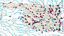
| Figure 1. Streamflow monitoring sites, water year 1999. |
Water quality can deteriorate during drought. The smell and taste of water supplies have been affected in some areas because of algal blooms in lakes as lake levels decline and chemical conditions change. In addition there is less dilution of wastewater discharges during drought because of the reduced flow in the streams. State regulations use the median 7-day low flow, called the 7Q2, to estimate the dilution potential of the receiving stream and the acceptable quality of the discharged waste. Accurate monitoring of streamflow (fig. 1) during drought is critical to determine the effect of wastewater discharges on streamwater quality and to provide data used to calculate an accurate and up-to-date 7Q2.
The ability to anticipate the availability of water from streams, reservoirs, and aquifers during a drought is critical to management of scarce and dwindling resources. Accurate and timely streamflow data also are needed during a drought to
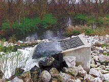
| Figure 2. Water from municipal and industrial waste-water plants is discharged after treatment directly to streams, such as at this site on the Canadian River. Design of the treatment plants and management of their discharge in order to protect streams from degradation relies on historic streamflow data. |
The U.S. Geological Survey (USGS) operates a statewide network to monitor streamflow. This network, which benefits all Oklahomans, exists because of the supportive partnerships between Federal, State, and local governments. Streamflow data are available online through the USGS Oklahoma home page at http://wwwok.cr.usgs.gov/.
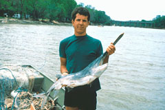
| Figure 3. The paddlefish is identifiable by its broad, flat, bill-like snout. |
USGS scientists at the Oklahoma Cooperative Fish and Wildlife Research Unit assessed the population structure, habitat use, and reproductive activity of native paddlefish (fig. 3) in the Arkansas and Cimarron River arms of Keystone Reservoir. The study was conducted in partnership with the Oklahoma Department of Wildlife Conservation. Previous anecdotal evidence suggested that paddlefish populations in the two rivers had been increasing since the construction of Keystone Reservoir in 1964. USGS scientists used mark-and-recapture and ultrasonic tracking techniques to measure population characteristics and identify environmental factors associated with spawning and seasonal movements. Spring and summer movement patterns were largely governed by rates of water flow. Paddlefish avoided the warmest and most saline areas of the reservoir. The paddlefish population appears to have adapted successfully to the altered water temperatures and fluctuating flows brought about by the construction of Keystone Reservoir.
The Oklahoma GIS Council, USGS, Natural Resources Conservation Service, and Farm Services Agency are working in cooperation to produce digital data products for Oklahoma. Digital orthophoto quadrangle images are precisely rectified, highly accurate digital aerial photographic images. Digital elevation model datasets are sets of regularly spaced elevations. There are literally hundreds of geographic information system (GIS) applications for which these digital products could be used to benefit the citizens of Oklahoma such as
The south bank of the Red River is the border between Oklahoma and Texas. For about 60 miles of this border, the nature of the Red River streambed and seasonal fluctuations in water level cause the river to change course, making it difficult to delineate an exact boundary between the States and causing decades-old land-ownership, tax-assessment, and jurisdictional problems. The Red River Boundary Commission was established by the U.S. Congress to determine a way to define the boundary permanently.
The Oklahoma members of the Commission propose to use USGS digital orthophoto quadrangles, digital elevation models, and global positioning system (GPS) technology to help determine the boundary. Instead of measuring the fluctuating south bank of the river, the plan would delineate "fast land" as the boundary between the States. Fast land is defined as the land adjacent to a stream that was created by the depositional processes of the stream and that is no longer inundated by the waters of the stream, except during major floods. The proposed plan would use the digital data for the Red River, along with field surveys using GPS and other techniques, to determine the fast land boundary and then to erect permanent markers delineating the boundary. The use of digital data should dramatically improve the speed and accuracy with which this and other such projects can be completed.
The upper Washita River watershed in Oklahoma is the subject of a cooperative project between the USGS and the U.S. Environmental Protection Agency (EPA) designed to develop a method for rapid and accurate delineation of watershed boundaries that can be applied nationwide. An improved version of digital elevation data, termed the National Elevation Dataset, is being used in combination with the National Hydrography Dataset of streams and waterbodies and electronically scanned maps to delineate watershed areas more precisely. A detailed delineation of watershed areas is required for many types of environmental studies, such as determining the effect of land use on water quality and availability and for modeling flood-frequency.
The USGS, as part of the National Oil and Gas Assessment Project, is determining the amount of natural gas in the Anadarko Basin, one of eighteen priority provinces in the United States estimated to contain 90 - 95 percent of the known and undiscovered natural gas resources. Undiscovered natural gas resources, including conventional and continuous resources, will be assessed. The petroleum geology of the basin will be studied, including source rock characterization, hydrocarbon movement, timing of movement and structural evolution, sequence stratigraphy, and gas quality.
Naturally occurring radioactive material (NORM) occurs as dissolved radium in oilfield-produced waters and in scale and sludge on oilfield equipment. NORM forms when minerals, particularly barite, precipitate from water produced during drilling as the temperature and pressure drop. At some sites, NORM may occur in soils as a result of spills of produced water, scale, and sludge. The EPA estimates that about 30 percent of the producing oilfields in the United States have enough NORM to warrant health and environmental concerns. The main health risks for humans are direct gamma radiation from NORM-bearing soils and equipment, breathing of NORM-bearing dust, or breathing indoor radon in structures built on NORM-affected soils. Several States are regulating NORM in oilfield operations. Oklahoma has proposed regulations that would limit radium activity in soils at NORM-affected sites to 30 pCi/g (picocuries per gram) and radioactivity in equipment to 50 microR/hr (microrems per hour). The EPA is gathering information about NORM in several different mining, mineral processing, and energy industries in preparation for proposing regulations.
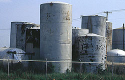
| Figure 4. Abandoned tanks and pipes may contain radium in scale and sludge. |
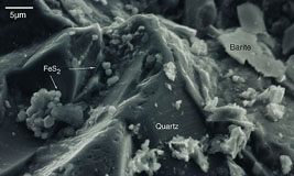
NORM is found in some areas of Oklahoma. In a 1989 American Petroleum Institute survey of radioactivity in gas processing and oil production equipment, elevated levels of NORM in oil-production equipment were found most often in counties in eastern and northeastern Oklahoma. Studies by the USGS in Osage and Lincoln Counties show that NORM occurs in the bottoms of produced-water tanks, (fig. 4) in stacks of scaled, corroded pipe left on older production sites, in tank sludges placed on soils or spilled on roads, in material removed from a wellbore during injection well workovers, and in pipe recycled for use in cattle guards. Most of the NORM-affected soils contain 5-30 pCi/g of radium. Radium in some of these tank sludges and scales exceeded 2,000 pCi/g. Erosion of spilled material tends to disperse and dilute the NORM-bearing solids to lower levels over distances of a few to several meters downslope. The radium bearing barite in the sludges does not easily dissolve in water, therefore, not much radium is being released to water that comes into contact with sludge.
| Figure 5 . Electron microscope study of the sand and clay was used to identify naturally occurring minerals, including barite, that react to decrease landfill contamination. |
Substances dissolved and suspended in ground water are partly dependent on reactions between the water and rock or sediment. Studies of an abandoned landfill near Norman are an example of how USGS scientists study the manner in which these reactions change water quality. Sand and clay deposited by the Canadian River react with contaminants dissolved from waste buried in the landfill (fig. 5). Some of these reactions actually decrease the toxicity of the water by decreasing a contaminant concentration or altering the potentially toxic substances. For example, USGS scientists determined that sodium, potassium, and ammonia in contaminated ground water from the landfill are exchanged with calcium and magnesium on clays. This exchange decreases the amount of sodium and ammonium in the water and, therefore, diminishes the toxic effects of these elements. Some reactions between water-borne contaminants and soils and rocks are indirect and result from bacteria in the sediment. USGS scientists are working with microbiologists at the University of Oklahoma to understand these changes. Bacteria in the sediment use organic compounds in water for food. Because some of these compounds are toxic, the bacteria actually clean the water. Studies of the sediment detected the sources of important compounds that the bacteria need to be able to process the organic substances in the water. One group of bacteria at the landfill needs sulfate to use the dissolved organic compounds. USGS scientists detected barite in sand as a possible sulfate source. Based on these observations, University of Oklahoma microbiologists conducted experiments that demonstrated the potential of barite to supply sulfate to bacteria and increase the rate at which bacteria alter organic compounds. This knowledge could be applied to an economical reduction of environmental risk from natural and human-caused toxins.
Eastern wild turkey populations have declined in southeastern Oklahoma during the past decade. USGS scientists at the Oklahoma Cooperative Fish and Wildlife Research Unit, in cooperation with the Oklahoma Department of Wildlife Conservation, recently completed a 3-year investigation of turkey nesting success and adult survival to identify factors responsible for the population declines. More than 130 female turkeys were radio collared and monitored to identify patterns of habitat use and to locate nests. About four of every five nests failed due to predation of turkey eggs or chicks. Annual survival of females was relatively low, ranging from 48 to 60 percent. The study concluded that predation by bobcats, raccoons, and coyotes may be responsible for the low populations of turkeys; these predators have increased in numbers, perhaps because fewer are killed.
| Figure 6. The Conservation Reserve Program may be providing new breeding sites for the prairie chicken. |
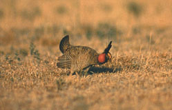
USGS scientists at the Oklahoma Cooperative Fish and Wildlife Research Unit are studying the effects of natural and human-caused changes to lesser prairie chicken breeding habitat in Oklahoma, Texas, and New Mexico (fig. 6). Rangewide population declines of this rare species prompted a recent petition for its listing under the Endangered Species Act. Scientists are assessing habitat change at 16 breeding sites by analyzing more than 400 historical aerial photographs. Scientists are using geographic information system software to correlate temporal changes in prairie chicken habitat with population trends at different traditional and nontraditional breeding areas. Preliminary results suggest that population declines in some areas may be partially offset by newly established breeding sites on Conservation Reserve Program and agricultural lands.
|
The USGS office locations
|
USGS State Representative USGS Home Page: Reports and products: |
| AccessibilityFOIAPrivacyPolicies and Notices | |
 |
|