|
The U.S. Geological Survey (USGS) is
involved in mapping and studying land, mineral,
biological, and water resources and
determining the risk from earthquakes and
other natural hazards, which are of importance
to the citizens of Pennsylvania. This
Fact Sheet describes how the USGS is
addressing some of the major environmental
issues in Pennsylvania, which include availability
of mineral resources; contamination
of the environment by hazardous wastes;
effects of coal mining, oil and gas production,
and agriculture on the environment;
nutrient input to streams and estuaries; and
adequacy of good-quality water supplies.
Information on acquiring the thousands of
map, book, and aerial photographic products
of the USGS also is given.
|
Mineral-Resource Information | |
|
The USGS Mineral Resource Data System (MRDS)
is a digital data base that contains information
from more than 110,000
sites nationwide and worldwide. The MRDS
provides information on the occurrence of
minerals and related data to Federal and State
agencies, industry, and the public. The
MRDS contains information on about 800
sites in Pennsylvania that relates mostly to
deposits of iron, limestone, sand, and gravel.
|
|
Mineral-Resource Assessment | |
|
The USGS is completing a prototype
quantitative national assessment of mineral
resources for five commonly used metals—gold,
silver, copper, lead, and zinc. The
assessment lists significant known deposits,
identifies areas with mineral potential, and
estimates the quantity of each metal present.
As a complement to the national assessment,
the USGS is conducting a more-comprehensive
regional assessment of the metallic- and
industrial-mineral resources in the Eastern
United States.
|
As part of this regional work,
the USGS is preparing an inventory of
known mineral resources in Pennsylvania
and is assessing the potential for undiscovered
mineral resources. This work involves compilation
of digital geological, geophysical, geochemical,
and mineral-deposit data.
Products include traditional maps and digital
(CD–ROM) data sets.
|
Continuous-Type Natural Gas Accumulation | |
|
A natural gas accumulation of regional
dimensions may be present in Lower Silurian
sandstone reservoirs in northwestern Pennsylvania,
eastern Ohio, western New York, and western West
Virginia. This continuous-type accumulation is
at the edge of largely
depleted oil and natural gas fields in central
and east-central Ohio. The reservoirs of the
continuous-type accumulation are at greater
depth, are less permeable, and yield less gas
per well than reservoirs in discrete-type
accumulations.
|
However, reservoirs in the
continuous-type accumulation probably are
gas saturated, and nearly all wells completed
in this accumulation should be productive
after hydrofracturing. Several tens of trillions
of cubic feet of gas may be recoverable from
the accumulation. The USGS has begun a
multi-year investigation to increase understanding
of the nature, size, and origin of the
accumulation.
|
Contamination of Water by Hazardous Wastes | |||||
|
The USGS, in cooperation with the U.S.
Department of Defense and the U.S. Environmental
Protection Agency (USEPA), has
studied hazardous wastes in ground water at
numerous sites in Pennsylvania. For example,
the USGS recently completed a study at
a Superfund site at Warminster in Bucks
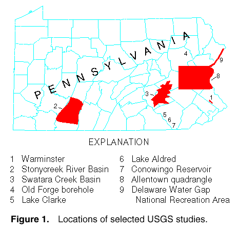
County (fig. 1, site 1)
to determine the distribution,
transport, and fate of volatile organic
compounds (VOC's). Several methods were
used to investigate the geohydrology of the
site, including borehole geophysical logging,
measurement of vertical borehole flow, isolation
of specific zones in the borehole for
depth-discrete hydraulic testing and water-sample
collection, drilling, coring, installation of
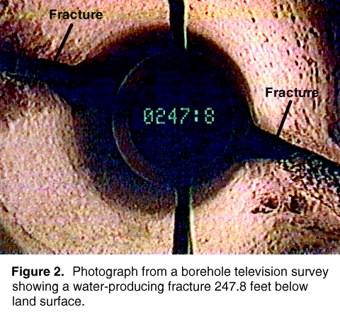
monitor wells, and continuous water-level monitoring. Borehole geophysical logs were used to construct a map of the underground rock layers at the site. Borehole television surveys (fig. 2) were used to help understand the geophysical logs and to locate smooth sections of the boreholes where packers could be inflated. Aquifer-isolation tests were run in six boreholes by inflating rubber-bladder packers above and below a water-bearing fracture. By placing a pump between the packers, hydraulic testing was conducted, and a water sample for laboratory analysis was collected. Elevated quantities of several VOC's were detected in most water samples. The downward hydraulic head gradient at the site, which was partly the result of the pumping of nearby public supply wells, caused the downward vertical migration of VOC's deeper into the aquifer through three wells with open-hole construction in the main contamination area. The VOC's then moved outward into the aquifer at different depths in response to the pumping of nearby wells and natural hydraulic gradients. The results of this study are enabling the USEPA to evaluate and improve the remedial activities at the site.
|
| ||||
Discharges From Coal Mines | |||
|
Acidic drainage from abandoned and
active coal mines has affected more than
2,400 miles of streams and associated
ground water in Pennsylvania. Increased
concentrations of sulfate and metals in mine
drainage make the water unfit for most uses
and are toxic to aquatic organisms. To assist
State, Federal, and local agencies in their
efforts to remediate and improve utilization
of affected waters, the USGS has documented
the extent and severity of surface-water
and ground-water contamination associated
with bituminous coal mining in western
Pennsylvania and anthracite coal mining in
eastern Pennsylvania and has evaluated the
effects of mining and reclamation practices
and water-treatment methods on water quality.
These studies have been supported by
the USEPA, the Office of Surface Mining,
the Pennsylvania Topographic and Geologic
Survey of the Department of Conservation
and Natural Resources (PaDCNR), the
Pennsylvania Department of Environmental
Protection (PaDEP), the Philadelphia Water
Department, the Somerset County Conservation
District, coal companies, and The
Pennsylvania State University. In the Stonycreek River Basin in Somerset and Cambria Counties (fig. 1, site 2), 270 discharges from coal mines were precisely located, sampled, and prioritized (ranked) with respect to their loading on the receiving stream, and 37 streamwater sites were sampled during base-flow conditions. A ranking index was developed for all streams in six subbasins of the Stonycreek River Basin that were moderately to severely affected by discharges from coal mines. This ranking provides a basis for selecting the sites for remediation that will provide the greatest improvement in stream quality at the least cost. In the Swatara Creek Basin in Schuylkill County (fig. 1, site 3), mine-drainage treatment systems are being evaluated to improve understanding of the treatment process, so that PaDEP can design cost-effective treatment systems to protect water quality in a proposed reservoir. At the opening to the Orchard Mine, three 80-foot-long limestone drains were constructed in parallel; access points in the drains enable collection of water, gas, and rock samples. As water flows through the drains, concentrations of alkalinity and calcium increase; concentrations of acidity and dissolved and suspended iron and aluminum decrease; and concentrations of sulfate, magnesium, manganese, and trace metals are unchanged. Water at the inflow was very acidic; at the outflow it was nearly neutral.
|
A USGS study of large discharges from
mines in the anthracite coal fields shows that
many mines discharge water with increased
concentrations of aluminum, calcium, cobalt,
iron, lithium, magnesium, manganese, nickel,
strontium, zinc, and sulfate. From 1975 to
1991, the acidity of water discharged from
most mines in this region decreased and
concentrations of iron, manganese, and sulfate
decreased. Figure 3 shows the decrease in
iron concentration in water from the Old
Forge borehole (fig. 1,
site 4), which is a
major discharge point in the Northern
Anthracite Field. Borehole discharge ranges
from about 4 to 400 cubic feet per second,
but discharge does not appear to have any
long-term trend. Changes in the exposed surface
area of limestone drains caused by dissolution
and, possibly, coating of sulfide
minerals probably account for most of the
improvement in water quality with time that
has been observed at many mines in the
anthracite region. This study provides the
data that PaDEP can use to plan remedial
activities and to determine the effects of new
mining on water quality.
|
||
Sediment in the Lower Susquehanna River | |||
|
Many State and Federal agencies are
involved in a major effort to protect and
improve water quality in the Chesapeake Bay.
The USGS has undertaken several studies to
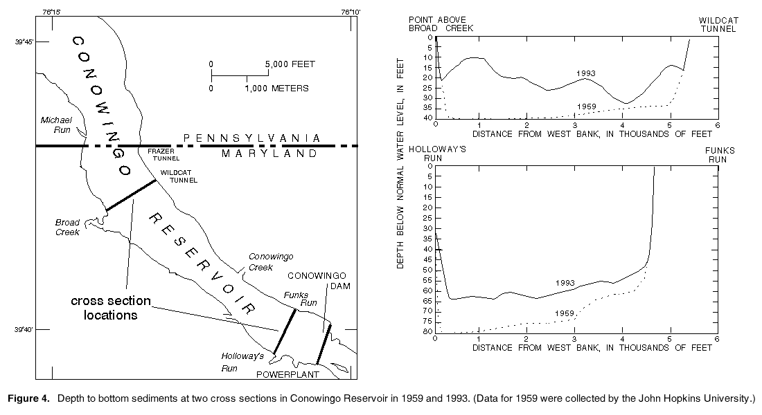
support this effort. The Susquehanna River drains 27,510 square miles in New York, Pennsylvania, and Maryland and is the largest contributor of sediment to the upper Chesapeake Bay. Data collected by the USGS and the Susquehanna River Basin Commission have shown that, in an average year, streams in the Basin transport 150 pounds per acre of sediment from forested land, 1,100 pounds per acre from cropland, and 2,200 pounds per acre from areas that are undergoing development. During an average year, the Susquehanna River transports about 3.3 million tons of sediment, but only 0.89 million tons enters the Chesapeake Bay. Three large hydroelectric dams span the lower Susquehanna River. Safe Harbor (Lake Clarke) and Holtwood (Lake Aldred) are in southern Pennsylvania, and Conowingo (Conowingo Reservoir) is in northern Maryland about 10 miles upstream from the Chesapeake Bay (fig. 1, sites 5, 6, 7). The reservoirs behind the dams have trapped large quantities of sediment, nitrogen, and phosphorus and kept the sediment and nutrients from reaching the Bay. In fall 1990, sediment stored in the three reservoirs was about 260 million tons. About 33 percent of the sediment in the three reservoirs is sand and coal. The sediment in the reservoirs contained about 814,000 tons of organic nitrogen, 98,900 tons of ammonia (as nitrogen), and 226,000 tons of phosphorus.
|
Lake Aldred and Lake Clarke reached
equilibrium with incoming river sediment by
1910 and 1950, respectively, and have no
capacity to store additional sediment. The
original (1928) capacity of the reservoir
formed by Conowingo Dam was about
300,000 acre-feet. USGS studies show that by
1990, deposition of sediment reduced
the capacity to 196,000 acre-feet. When
Conowingo Dam was completed in 1928, the
reservoir ranged from 100 feet deep just
above the dam at Holloway's Run to about 60
feet deep at Broad Creek. Surveys by the
USGS in 1993 indicated depths of about 62
feet just above the dam and about 22 feet at
Broad Creek (fig. 4). Once the average depths
in the reservoir are reduced to about 55 feet
just above the dam and to about 15 feet at
Broad Creek, the reservoir will no longer
accumulate sediment. Conowingo Reservoir
will probably reach equilibrium and cease to
accumulate sediment in the next 20 or 30
years. As the capacity of Conowingo Reservoir
to store additional sediment decreases,
the loads of sediment, nitrogen, phosphorus,
and metals that reach the Chesapeake Bay
from the Susquehanna River will increase.
Because this may adversely affect habitat in
the Bay, understanding the effect that reservoir
filling will have is of critical importance
for planning the actions that need to be taken
to protect the Bay.
|
||
National Water-Quality Assessment Program | |||
|
The National Water-Quality Assessment
(NAWQA) Program involves studies of 60
major hydrologic basins of the United States.
It is designed to describe the status and trends
in the quality of the Nation's surface-water
and ground-water resources and identify the
natural and human factors that affect the
water quality. The NAWQA Program
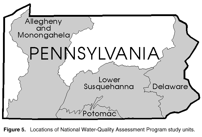
includes four river basins in Pennsylvania.
The Lower Susquehanna and the Potomac
River Basin studies began in 1991. The Ohio
River Basin (Allegheny and Monongahela
Rivers) study began in 1994. A NAWQA Program
study of the Delaware River Basin is
scheduled to begin in 1997 (fig. 5). Consistent study designs are achieved by dividing the Basins into subunits on the basis of physiography, lithology of bedrock, and land use. By using standardized methods of sampling and data analysis, results are comparable among different river basins and subunits. The primary focus of the Lower Susquehanna and the Potomac River Basin studies has been on the occurrence of nitrogen, phosphorus, and herbicides. The concentrations of nitrogen and herbicides indicate that the streams and ground water in each of the subunits have different sources of these contaminants and different degrees of water-quality problems. For example, concentrations of nitrate nitrogen in streams and ground water from agricultural subunits underlain by limestone bedrock are significantly higher than average values from the other subunits with less agricultural land use. In addition to water quality related to agriculture, such important issues as bacteria and radon concentrations in water from rural wells and the concentrations of VOC's have been addressed in these studies.
|
The USGS, in cooperation with several
other Federal agencies, is acquiring satellite-image
data for the entire United States to provide
current information on land use. These
data are used by the NAWQA Program
projects to help determine the effects of land
use on water quality.
|
||
Geologic and Hydrologic Mapping | |
|
Bedrock and surficial geologic maps and
hydrologic maps are prepared by the USGS.
These maps are essential for studies of water
contamination, resource availability,
environmental effects of mineral extraction, hazard
mitigation, and land-use management.
|
The USGS, in cooperation with the Pennsylvania
Topographic and Geologic Survey
and Bloomsburg University, is preparing
surficial and bedrock geologic maps of the
Allentown 1:100,000 quadrangle and component
1:24,000 quadrangles (fig. 1, site 8).
These maps and derivative products are
being used by the Lehigh–Northampton
County Joint Planning Commission to develop
wellhead-protection strategies. The USGS
also is cooperating with the National Park
Service in the Delaware Water Gap National
Recreation Area (fig. 1, site 9) by supplying
and interpreting geologic data for public
outreach, training of park rangers, and park
management.
|
Topographic Mapping | |||
|
The National Mapping Program of the
USGS strives to ensure the availability of map
data in graphic and digital forms to the public
through timely data collection and revision
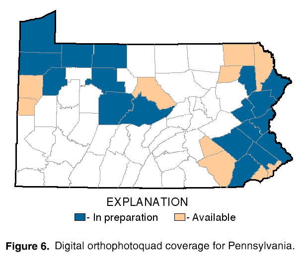
procedures. Among the most popular and versatile products of the USGS are its 1:24,000-scale topographic maps (1 inch on the map represents 2,000 feet on the ground). These maps depict basic natural and cultural features of the landscape, such as lakes and streams, highways and railroads, boundaries, and geographic names. Pennsylvania is covered by 876 maps at this scale. About 90 percent of Pennsylvania is covered by digital elevation model (DEM) data and work is in progress to complete the coverage. Among other uses, DEM's have been used to construct hydrologic models, determine landslide probability, and assist in forest fire control. The USGS, in cooperation with PaDCNR, completed statewide aerial photographic coverage between 1992 and 1994 that is being used to prepare digital orthophotoquads (DOQ). A DOQ is derived from digitized aerial photographs, with displacement caused by camera tilt and terrain relief removed. It combines the image characteristics of a photograph with the geometric qualities of a map. They are becoming increasingly useful in geographic information system databases, where they are used in combination with other data. DOQ's have been completed for 10 counties and are being prepared for 18 counties (fig. 6). The USGS, in cooperation with PaDEP, was preparing statewide 1:24,000-scale digital raster graphic (DRG) coverage during 1995. A DRG is a scanned image of a topographic map that retains the positional accuracy of the map in raster format. A DRG can be the basic reference layer for a geographic information system, thus allowing digital spatial data to be overlaid or integrated with a high degree of accuracy. The USGS and PaDEP are cooperating on the production and demonstration of a spatial data set of the Lake Erie shoreline to be used for coastal zone management. This data set is available on CD–ROM and includes DRG's, DOQ's, DEM's, and digital line graphs.
|
An Earth Science Information Center operated
by the Pennsylvania Topographic and
Geologic Survey in Harrisburg, provides
information on such earth science topics as
cartography, geography, digital data, remote
sensing, geology, geophysics, geochemistry,
hydrology, aerial photography, and land use.
The Center is operated in cooperation with the
USGS and is supported by the USGS with
reference materials, technical assistance, training
and outreach activities, and access to USGS
data bases.
|
||
Collection of Hydrologic Data | |
|
The USGS, in cooperation with more than
30 local, State, and Federal agencies, collects
streamflow, ground-water, and water-quality
data at sites throughout Pennsylvania. Many
of these data-collection sites are equipped
with data-collection platforms that use radio
and satellite relay technology to provide
near-realtime data to the users. These data are
helpful for day-to-day administration and
management of water resources, determining the
extent and severity of droughts, characterizing
and predicting conditions during floods, and
monitoring the effects of human activities on
water resources, among other uses.
|
|
Cooperative Programs | |
|
The USGS cooperates with more than 30
local, State, and Federal agencies in Pennsylvania.
Cooperators include State agencies,
counties, municipalities, basin commissions,
water authorities, universities, and other
Federal agencies. Cooperative activities include
water-resources data collection, interpretive
water-availability and water-quality studies,
mineral-resource assessments, mapping, and
studies of channel instability and scour at
more than 16,000 highway bridges over water.
When local or State agencies are involved,
activities typically are funded by USGS and
cooperating agencies on a 50–50 matching
basis. In addition to the agencies already
mentioned, the USGS in Pennsylvania cooperates
with the U.S. Army Corps of Engineers, the
Chester County Water Resources Authority,
the Delaware River Basin Commission, and
the Pennsylvania Department of Transportation,
to name only a few.
|
The USGS provides support to the Environmental
Resources Research Institute of the
Pennsylvania State University, which
conducts a program of research, education, and
information and technology transfer.
|
from U.S. Department of the Interior, U.S. Geological Survey, Fact Sheet FS-038-96
For more information contact any of the following: | |
|
USGS State representative 840 Market Street Lemoyne, PA 17043-1584
Phone: (717) 730-6900 Additional earth science information can be found by accessing the USGS Home Page on the World Wide Web at http://www.usgs.gov/ For more information on all USGS reports and products (including maps, images, and computerized data), call 1-888-ASK-USGS
|
The USGS provides maps, reports, and information to help others meet their needs to manage, develop, and protect America's water, energy, mineral, biological, and land resources. We help find the natural resources needed to build tomorrow and supply the scientific understanding needed to help minimize or mitigate the effects of natural hazards and environmental damage caused by natural and human activities. The results of our efforts touch the daily life of almost every American. |
USGS Fact Sheets (listed by state)
Maintainer: USGS Fact Sheet Team. If you have suggestions for this page, please let us know!
http://water.usgs.gov/lookup/get?fs03896
Web version by: Steven Siwiec
Last modified: 10:23 27 Mar 97 ghc