![]()
This picture is from USGS FS-038-99
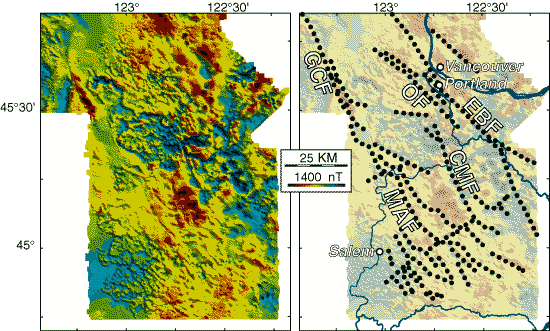
Figure 3. The colors on these aeromagnetic maps of the Portland-Salem area indicate the intensity of the magnetic field near the ground surface, which in turn reflects the magnetic properties of underlying volcanic rocks. Both maps show the same magnetic data; the map on the right highlights interpreted geologic structures. The dotted lines on the map show the location of several magnetic linears, some of which are caused by faults. These magnetic data are being used in conjunction with geologic mapping and other earth-science studies to characterize faults in the northern Willamette Valley. Faults: MAF, Mount Angel Fault; GCF, Gales Creek Fault; OF, Oatfield Fault; EBF, East Bank Fault; CMF, Canby-Molalla Fault. KM, kilometer; nT, nanotesla.