Most USGS work in Texas involves the appraisal of the State's water resources in cooperation with more than 80 local, State, and Federal agencies. The foundation of a wide range of hydrologic data-collection and interpretive programs is the stream-gaging program. The Texas network of streamflow-gaging stations, which provides water data for water-resources planning and design, hydrologic research, and operation of water-resources projects, is part of a nationwide aggregation of networks that is unique because of nationally consistent, prescribed standards by which the data are collected and processed.
Monitoring Floods, Droughts, and Earthquakes
 (Click on image for a larger version, 165K JPEG) |
| Figure 1. Severe drought in Central Texas is reflected by the dry, cracked streambed of the Pedernales River, July 1996. Mean annual flow of the Pedernales near the site of the photograph is about 200 cubic feet per second. |
In 1995, a magnitude 5.3 earthquake struck the Alpine-Marathon area of Texas. The largest historical earthquake, magnitude 6.4, to strike this region occurred in 1931 near Valentine. Both earthquakes caused damage; however, neither was large enough to rupture the ground surface. Large, surface-rupturing earthquakes (magnitude greater than 6.5) have not occurred in west Texas in historic times, but geologic evidence suggests that they might have in prehistoric times. The USGS, in cooperation with the Bureau of Economic Geology, has recently completed a compilation of data on potentially active faults in west Texas and adjacent Mexico. The compilation includes a conventional map (1:500,000 scale) and fully documents published information on 24 faults with evidence of surface rupture within the last 1.6 million years. The compilation is particularly useful for seismic hazard evaluation of regions, such as west Texas, that have low seismicity. The compilation is the first of many similar State and regional compilations that are planned for the United States.
Water-Quality Trends
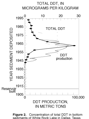
One of the first sites where the USGS applied the technique is White Rock Lake, which is a 2-square-mile reservoir in northeastern Dallas. Soils from the watershed have been eroding from the land surface into streams and subsequently accumulating on the bottom of the reservoir since its construction in 1912. By analyzing discrete sections of age-dated sediment cores, scientists are able to reconstruct water-quality conditions associated with the change from agricultural to urban land use and with the implementation of more stringent environmental controls.
 (Click on image for a larger version, 33K JPEG) |
| Figure 2. Concentration of total DDT in bottom sediments of White Rock Lake in Dallas, Texas. |
U.S.-Mexico Border Activities
 (Click on image for a larger version, 66K JPEG) |
| Figure 3. USGS environmental and mapping activities in the Rio Grande/Rio Bravo border region are increasing as a result of the North American Free Trade Agreement. |
Within the Rio Grande/Rio Bravo international watershed, the USGS is using age-dated bottom-sediment cores from reservoirs to define historic trends in water quality. This approach is being applied to Cochiti Lake and Elephant Butte Reservoir, New Mexico, International Amistad Reservoir, Texas/Coahuila State, Mexico, International Falcon Reservoir, Texas/Tamaulipas State, Mexico, and Laguna Madre, Texas. Occurrence and trends in radioactive elements in the upper Rio Grande Basin and pesticides and trace metals in the middle and lower parts of the Basin are of particular interest. The study is a cooperative effort with the Texas Natural Resource Conservation Commission, the El Paso County Water Conservation and Improvement District No. 1, the U.S. Bureau of Reclamation, and the Pueblo de Cochiti Tribe, in consultation with the International Boundary and Water Commission, the New Mexico Environment Department, and the U.S. Department of Energy.
The USGS is acquiring data needed in the border region of Texas to address surface-water quality issues that could arise as the region continues to develop. Data for future constituent trend analyses and studies of constituent transport and of processes, such as storage and remobilization of sediments and associated contaminants, are being collected. Data-collection sites are on the mainstem of the Rio Grande (six sites), at the Pecos River near Langtry, and at the Arroyo Colorado near Harlingen. The new water-quality initiative in the basin is associated with the USGS National Stream Quality Accounting Network, the focus of which is on the quantity and quality of water that moves within and from large river basins.
The USGS is cooperating with local, State, and Federal agencies and other organizations in the United States and Mexico to develop digital map data for the border area. These data support a wide range of studies by scientists of environmental and resource-management agencies on both sides of the border. Cartographic data are being collected within a 100-mile zone on each side of the border (fig. 3). In 1996, the USGS acquired color-infrared aerial photographs for the 100-mile zone on the U.S. side of the border. The USGS is producing digital orthophotoquads from the color-infrared aerial photographs. A digital orthophotoquad combines the image characteristics of a photograph with the geometric qualities of a map. The digital orthophotoquads are useful for revising and upgrading various maps, which include the popular USGS 1:24,000-scale topographic maps, along the border.
New Maps for Texas
National Coal Assessment
Texas ranks sixth in coal production in the United States. Most coal in the Gulf Coast area is used as fuel for electric power-generating plants. In the National Coal Assessment in Texas, the USGS is working with the Bureau of Economic Geology and the Railroad Commission of Texas to provide high-quality, organized information and interpretations on the location, quality, and quantity of the coal to be mined during the next several decades. Particular attention is being given to the characterization of hazardous air pollutants identified by the 1990 Clean Air Act Amendments.
Potential for Desertification of the Texas High Plains
Desertification is the loss of productive land. A cooperative study by the USGS, the Museum of Texas Tech University, and the University of Wisconsin suggests that stabilized sand dunes on the Texas High Plains could become active with only slight changes in climate. Sand dunes presently stabilized by sparse vegetation occur over much of the Texas Panhandle and adjacent States. Radiocarbon dating and soils studies indicate that more than 1 million acres of these dunes have been active in the past 1,000 years. Historical observations and examination of archival aerial photographs indicate appreciable areas of dune activity in the 19th century and during the 1930's drought. In a 21st century "greenhouse" climate or even under natural climatic cycles, the potential for reactivation of these dunes is high. Activation of presently stabilized sand dunes would significantly impact grazing, agriculture, and transportation routes in the Texas Panhandle.
Texas Earth Science Information on the World Wide Web
The Texas USGS website is continually evolving and improving. Currently (1996), available data include realtime and historic streamflow data, water-quality and ground-water data, peak-discharge information, and monthly precipitation data (obtained from the National Weather Service). For example, a canoeist interested in current streamflow conditions on the Guadalupe River in central Texas can access and retrieve an up-to-date hydrograph (or tabular data) of flow at the USGS streamflow-gaging station at Comfort. Each of the online data bases allows searching for information by county, hydrologic basin, or keyword search.
The USGS also is assisting local and State government agencies, universities, and private firms to develop and make accessible on the WWW spatial data that incorporate Federal Geographic Data Committee (FGDC) policies and standards. This assistance comes through the National Spatial Data Infrastructure (NSDI) Competitive Cooperative Agreements Program (CCAP), which was established by the FGDC through the USGS. One of three recent CCAP grants awarded to Texas will enable the University of Texas at Dallas, Bruton Center for Development Studies, to establish a NSDI website with procedures in place to make its data holdings consistent with FGDC standards.
Earth Science Information Centers
Earth Science Information Centers (ESIC's) and their affiliates nationwide provide information to the public about USGS programs, products, and technological developments. The Texas Natural Resources Information System in Austin is an ESIC affiliate. As part of the national ESIC network, this office provides information on cartography, geography, digital data, remote sensing, geology, geophysics, geochemistry, hydrology, geohydrology, aerial photography, and land use. It is supported by the USGS with reference materials, technical assistance, training and outreach activities, and access to USGS data bases.
A New USGS Division--Biological Resources
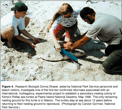
The USGS is cooperating with government agencies and private entities on long-term research at Padre Island National Seashore to increase understanding of five species of threatened or endangered sea turtles of the northwestern Gulf of Mexico. Data are being gathered to help scientists determine ways to protect, manage, and recover sea turtle populations ( fig. 4)
 (Click on image for a larger version, 66K JPEG) |
| Figure 4. Research Biologist Donna Shaver, aided by National Park Service personnel and beach visitors, investigate one of the first two confirmed returnees associated with an international, multiagency, experimental project to establish a secondary nesting colony of Kemp's Ridley sea turtles at Padre Island National Seashore, May 1996. The only remaining nesting ground for this turtle is in Mexico. The turtles stay at sea about 12 years before returning to their nesting ground to reproduce. (Photograph by Carolyn Gorman, National Park Service.) |
USGS scientists serve on technical advisory committees for several oil companies that fund major research projects in the Gulf of Mexico.
USGS toxicologists contribute to oil-spill contingency planning in Galveston Bay and other critical areas.