This document is also available in pdf format: ![]() fs-045-99.pdf
fs-045-99.pdf
In 1997, the Texas Legislature passed a comprehensive revision to the Texas Water Code. This legislation (Senate Bill 1) changed water planning in Texas from a statewide to a regional activity. By September 2001, the 16 regions created by Senate Bill 1 must produce water plans to address their water needs during drought-of-record conditions, and must identify water-management strategies for periods when stream-flows, reservoir storage, and ground-water levels are 50 and 75 percent of normal.
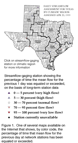
| Figure 1. One of several maps available on the Internet that shows, by color code, the percentage of time that mean flow for the previous day at network stations has been equaled or exceeded. |
A key aspect of the mandated planning is assessment of current and near-realtime hydrologic conditions. The USGS, in cooperation with the Texas Water Development Board, has begun a project to develop and maintain online maps and tables on the Internet that present comparative and descriptive assessments of current streamflows, reservoir storage, and ground-water levels for climatic regions, hydrologic regions, and river basins of Texas (fig. 1).
The statewide assessment network currently comprises 30 streamflow stations, and ultimately will comprise 50 streamflow stations, 124 reservoirs, and 40 wells. Online State maps show network stations linked to tables of current and the past 7- and 30-day streamflows, percentages of time that current values are exceeded, and other station-specific information.
The hydrologic assessment for Texas can be accessed through the USGS Texas home page at http://tx.usgs.gov/.
The U.S. Environmental Protection Agency (EPA) initiated the Environmental Monitoring for Public Access and Community Tracking (EMPACT) Program in 1998. The goal of EMPACT is to provide public access to accurate, clearly communicated, timely environmental monitoring data--physical, chemical, and biological information intended to give insight into environmental conditions--in 75 major metropolitan areas of the country.
The USGS, in cooperation with the EPA, initiated a pilot EMPACT project in 1998 to monitor and report on the water quality at three sites on Buffalo Bayou, a primary stream in the Houston metropolitan area and tributary to the Houston Ship Channel. All data collected are to be presented on the Internet through the EPA home page. Monitored water-quality properties are to be provided on a near-realtime basis in graphical and tabular displays that include explanatory information, descriptive statistics, and applicable State standards for the selected properties.
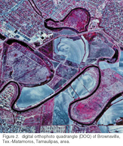
| Figure 2. Digital orthophoto quadrangle (DOQ) of Brownsville, Tex.- Matamoros, Tamaulipas, area.. |
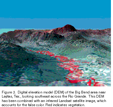
The Texas Strategic Mapping Initiative (StratMap) is a multiyear initiative among the State of Texas, the USGS, and local partners to develop current digital data layers for Texas. The data layers include digital orthophoto quadrangles (DOQ) (fig. 2), digital elevation models (DEM) (fig. 3), high-resolution water features, topographic contours, transportation, boundary, and soil surveys. A DOQ is a digital image of an aerial photograph that combines the image characteristics of a photograph with the geometric qualities of a map. The DOQ's, created from 1995 to 1997 color-infrared photographs, are the foundation for developing the other data layers. A seamless DEM of the entire State will be used to delineate small watersheds; this information is essential for water management and protection. The high-resolution hydrography will be integrated into the National Hydrography Dataset, a well-documented, maintainable, and nationally consistent dataset for hydrologic modeling that the USGS and the EPA are cooperatively developing.
| Figure 3. Digital elevation model (DEM) of the Big Bend area near Lajitas, Tex., looking southeast across the Rio Grande. This DEM has been combined with an infrared Landsat satellite image, which accounts for the false color. Red indicates vegetation. |
StratMap is a model approach to encouraging cooperation with private, local, State, and Federal agencies to create a spatial data framework that is too costly for any single entity to finance. Appropriations in Texas Senate Bill 1 provided initial funding for StratMap. The USGS has established a Texas mapping liaison office in Austin to help support this cooperative effort.
The assessment of Texas Gulf Coastal Plain coal deposits is part of the USGS National Coal Resource Assessment, a multiyear project to identify and characterize coal beds and coal zones that will provide the bulk of the Nation's coal-derived energy during the first quarter of the 21st century. Texas ranks sixth among the States in U.S. coal production. Most of the coal mined in Texas is used as fuel for electric power-generating plants. In Texas, the USGS is working with the Bureau of Economic Geology, the Railroad Commission, and mining companies to provide high-quality, digital, georeferenced databases and geologic interpretations characterizing the coal that is expected to be mined during the next 30 years in several priority areas. Geologic studies are underway to improve understanding of the stratigraphy of the coal-bearing beds. Emphasis is being given to characterization of coal geochemistry, including the environmentally sensitive trace elements identified by the U.S. Clean Air Act Amendments of 1990.
| Figure 4. General chemical composition of samples from the Austin Chalk from an oil well, Giddings field, Tex. The producing zone in this well is in the lower part of the Austin Chalk, where nonchalk material content is near or less than 10 percent, and brittle chalk rock content is most abundant.. |
The USGS also is conducting a National Oil and Gas Assessment to understand the geologic reasons for, and assess the availability of, oil and gas resources in the United States. In 1995, the Assessment determined that the Austin Chalk in Texas and Louisiana is the Nation's largest onshore domestic continuous-type, unconventional oil resource. "Unconventional" refers to a broad class of hydrocarbon deposits that cannot be developed by traditional methods. Recent exploration and production in the Austin Chalk (fig. 4) has shown that the unit has additional potential as a continuous-type deep-gas resource. In 1997, an Austin Chalk well in Washington County, Tex., set an initial gas-flow-rate record for horizontal wells in the United States of 84.7 million cubic feet per day.
USGS scientists are studying the stratigraphy and the burial and production histories of the Austin Chalk to determine a reasonable quantitative estimate of this large domestic oil and gas resource. Through such studies, scientists improve their understanding of the generation, distribution, accumulation, availability, and recoverability of oil and gas. For example, data and relations between composition and production demonstrate that productive intervals commonly have the lowest nonchalk material content and are the most "brittle" zones of the Austin Chalk. Knowledge of the distribution of the Austin Chalk assists scientists in outlining geographic extent, maturity, and economics, among other factors, needed to identify current and future exploration areas.
The United States and Mexico share concern about many environmental issues within the 2,000-mile border region that comprises parts of four U.S. and six Mexican States. The USGS is involved in many initiatives to provide relevant scientific information for this region of diverse physical settings and habitats.
Current, accurate, binationally compatible geographic and spatial data are required to develop appropriate and effective ways to address environmental issues. The USGS in Texas is working with Federal, State, and local agencies and other organizations in the United States and Mexico to develop digital map data for the 100-mile zone on each side of the border. From 1996 color-infrared aerial photographs of the zone on the U.S. side of the border, the USGS is completing DOQ's to be used to revise maps and databases necessary for environmentally related projects. High-resolution land-use and land-cover data from the DOQ's are being used in a cooperative USGS-Texas Natural Resource Conservation Commission (TNRCC) project to determine the relative contributions of contaminants from various areas to Arroyo Colorado, a stream near the mouth of the Rio Grande. The land-use data will be used in a watershed model developed by the USGS and applied by the TNRCC to obtain total maximum daily load allocations for selected contaminants in Arroyo Colorado.
The U.S. Department of the Interior High-Priority Digital Data Program has allowed the USGS, in partnership with private industry, to complete DEM's, digital raster graphs (DRG), and public land-survey system (where applicable) and boundary digital line graphs (DLG) for the entire U.S. part of the border region. A DRG is a scanned image of a USGS topographic map that can be used as a base to register, collect, and interpret other data. A DLG is a digital representation of areas, lines, and points composed of specific data.
Additional information about U.S.-Mexico border mapping is on the Internet at http://rmmcweb.cr.usgs.gov/usm/.
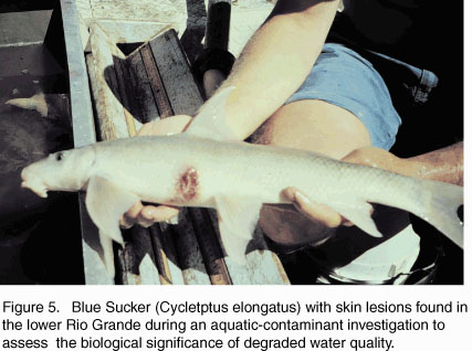
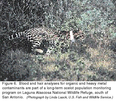
The Rio Grande Basin, which includes Big Bend National Park and the Lower Rio Grande Valley National Wildlife Refuge System, is a diverse and sensitive ecosystem. A multiphase binational toxic-substances study has shown some evidence of degraded water quality and habitat (figs. 5 and 6); however, little is understood about the specific sources of contaminants and the ecological effects of expanding industrial development and population growth.
|
|
USGS scientists are studying selected reaches of the lower Rio Grande, focusing on the relations between habitat degradation and the health of fish and wildlife communities dependent upon the river system. The USGS is conducting its work in collaboration with established binational partners in the border region--the U.S. Fish and Wildlife Service, Bureau of Reclamation, National Park Service, TNRCC, Texas Parks and Wildlife Department (TPWD); and counterparts in Mexico, which include the Commission for the Understanding and Use of Biological Diversity and the Secretary of the Environment, Natural Resources, and Fisheries.
The USGS has monitored water quality in the Rio Grande Basin as a part of the USGS National Stream Quality Accounting Network (NASQAN) since 1995. NASQAN is designed to characterize the concentrations and transport of sediment and selected chemical constituents in the Nation's large rivers. NASQAN sampling at eight sites in the Rio Grande Basin in Texas is providing information needed to identify regional sources of various constituents, including agricultural chemicals and trace elements.
The Kemp's ridley is the world's most endangered sea turtle. The only major nesting site for the sea turtle is a beach near Rancho Nuevo in Mexico. During the 1940's, an estimated 40,000 females nested on this Mexican beach. The number of nesting turtles dropped to the hundreds during the 1970's. In 1978, to help preserve the species, an international experimental project was launched at Padre Island National Seashore in Texas to establish a secondary nesting colony. In recent years, the discovery of Kemp's ridley turtle nests at Padre Island has confirmed the success of the program.
USGS scientists are conducting studies to document Kemp's ridley nesting and to protect, monitor, and incubate eggs in an effort to sustain the secondary breeding colony. Additional studies are focused on other species of sea turtles in the Mansfield Channel along the southern Texas coast.
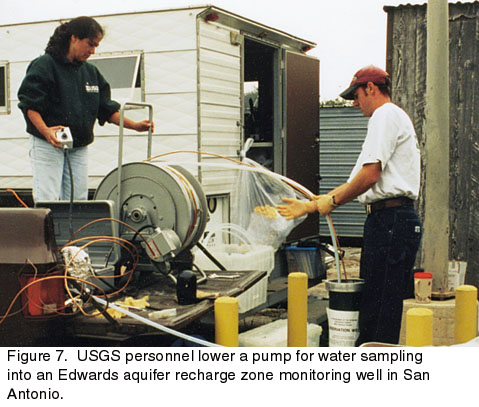
The highly productive Edwards aquifer is the sole source of water for San Antonio, and is the major source of water in south-central Texas. Most recharge to the Edwards aquifer is from direct infiltration of rainfall and streamflow losses in the faulted and fractured limestone outcrops of the recharge zone. The permeable rocks of the outcrop make the source water for public supply susceptible to contamination from spills or leakage of hazardous materials and runoff from rapidly developing urban areas on and near the recharge zone.
| Figure 7. USGS personnel lower a pump for water sampling into an Edwards aquifer recharge zone monitoring well in San Antonio. |
The USGS is assessing the quantity and quality of runoff and the quality of shallow ground water to learn more about the relations between residential and commercial land use and the quality of Edwards aquifer water in and near the recharge zone (fig. 7). Information to define current conditions and to assess potential land-use impacts is being developed through cooperative surface-water projects with the San Antonio Water System and ground-water projects supported by the USGS and the Edwards Aquifer Authority.
Working with the EPA, U.S. Department of Energy, Texas State Soil and Water Conservation Board, TPWD, and animal feedlot operators, the USGS has developed a treatment for wastewater from feedlots that makes the water suitable for reuse using constructed wetlands. Water and manure are collected from 1,000 head of cattle and 280 sows at the Texas Tech University Animal Science Facility in New Deal. The water and manure are directed through a series of ponds to allow settling of waste, removal of nutrients by aquatic plants, and removal of organic material by aquatic organisms. The treated water ultimately is diverted into a playa lake. This integrated treatment of feedlot wastewater demonstrates conversion of livestock wastes by microorganisms, aquatic plants, and animals including sulfur-reducing bacteria, microalgae, duckweed, and fish. The process also involves diverting some of the waste to an anaerobic pit designed for recovery of methane gas that is used on-site for producing steam and electrical energy.
|
The USGS has 180
|
USGS State Representative USGS Home Page: Reports and products: |
.gif)