|
|
The safety, health, and economic well being of West Virginia's citizens are
important to the U.S. Geological Survey (USGS), which is involved in water,
resource, mapping, and land-use issues in many parts of the State. Through
cooperative programs with many State and local agencies, the USGS is
studying coal extraction and its effects and assessing water quality and
mineral potential. Through national programs, citizens of West Virginia
have access to the thousands of map, book, and digital products of the
USGS. This Fact Sheet details some of the programs and activities of the
USGS in West Virginia.
|

|
|
|
|
Coal accounts for between 20 and 25 percent of the total energy used and
more than 50 percent of the electricity generated in the United States.
Coal from Appalachian Basin fields in West Virginia is a major resource for
the Nation. Assessment of potential coal development recognizes both
physical constraints and societal restrictions on mining. Since 1988, the
USGS, in cooperation with the West Virginia Geological and Economic Survey
(WVGES), has identified these restrictions as part of a national effort to
analyze the relation between mining restrictions and potential coal
availability.
New technologies that use coal will require resources of specific and known
quality. The economics of coal utilization depend on mining and
transportation costs. Coal quality affects those costs, especially with
respect to waste disposal. For example, high concentrations of sulfur in
coal beds and associated rocks may produce acid drainage after mining or
acid rain after combustion but may be beneficial in a synthetic fuel
process. The USGS, is supplying information to the WVGES, for development
of cost-effective strategies to predict areas of high potential for acid
production, to mitigate acidity problems, and to cleanup existing
contamination. |
Since 1975, the USGS, in cooperation with the WVGES, has evaluated and
correlated data from drill holes, mines, and outcrops by using the National
Coal Resources Data System. The USGS regularly provides the WVGES with
fossil and mineral analyses of key strata to identify coal beds better.
The location and quality of coal resources throughout the State will be
identified in the National Coal Assessment.
A natural gas accumulation of regional dimensions may exist in the deep
sandstone reservoirs in western West Virginia and other parts of the
Appalachian basin. According to the 1995 USGS National Assessment of
United States Oil and Gas Resources, several tens of trillions of cubic
feet of gas may be recoverable from this contiuous-type accumulation.
Recognizing the potential of this large energy resource, the USGS has begun
a multiyear study in West Virginia and adjoining States to increase
understanding of the nature, size, and origin of the continuous-type
accumulation.
|
|
|
|
|
|
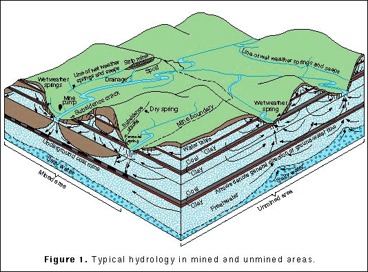
Coal mining and other forms of resource extraction, including logging or
drilling for oil and gas, affect West Virginians in many ways. The USGS,
often in cooperation with the WVGES, has completed numerous studies of the
economic, hydrologic, and water-quality effects of resource extraction
throughout the State. The fracturing and subsidence of rock layers that
result from underground mining increase the infiltration of precipitation
and streamflow and also increase the volume of water in subsurface storage
(fig. 1). These changes tend to reduce flood peaks and increase base flow
in streams. |

(Click on image for a larger version, 99K GIF)
|
|
Figure 1.Typical hydrology in mined and unmined
areas. | |
|
Water in mined areas generally has high concentrations of dissolved solids
because of increased contact between the water and subsurface minerals.
Where the sulfur content of the rocks is high enough, as is more common in
the northern part of the State, the water becomes acidic and may contain
undesirable concentrations of metals. The West Virginia Division of
Environmental Protection (WVDEP) reports that acid mine drainage has
affected at least 484 streams for a total of 2,852 stream miles. A recent
USGS assessment of potential mineral deposits included a map that shows the
distribution of acid stream water. In some rivers, acid drainage kills all
living creatures; in others, fish are able to live for a few weeks or
months but are unable to reproduce. Expanding suburbs in the Deckers Creek
Basin near Morgantown are affected by the area's history of acid mine
drainage. USGS sampling in the Basin during 1993-94 helped identify the
most heavily affected areas and allowed the U.S. Department of
Agriculture's Natural Resources Conservation Service to set priorities for
restoration. |
Land-surface disturbance related to resource extraction can increase
erosion, cause elevated concentrations of suspended sediment in streams,
and lead to deposition of sediment in reservoirs and navigable rivers.
Highway construction can produce large amounts of suspended sediment from
small areas, but sediment yield can be even larger in basins affected only
by mining and logging, according to USGS studies done in cooperation with
the West Virginia Department of Highways and the West Virginia Division of
Natural Resources. Like many other hydrologic processes,
suspended-sediment transport is most important under extreme conditions,
which makes monitoring, analysis, and interpretation difficult. For
example, during more than 4 years of study in one basin, 30 percent of the
total suspended-sediment movement occurred during just four storms.
|
|
|
|
|
|
An extensive data base of water-quality information for West Virginia has
been developed through resource assessments of individual basins, studies
of local problems, a series of federally funded coal hydrology studies, and
long-term monitoring at several stream-gaging stations. The data base,
however, is incomplete in the number of chemical and biological
characteristics measured and in the limited range of sampling times and
locations.
The USGS National Water-Quality Assessment (NAWQA) Program has long-term
goals to describe the status and trends in the quality of a large,
representative part of the Nation's surface- and ground-water resources and
to identify the natural and human factors that affect their quality. About
two-thirds of the State is included in three NAWQA Program study areas
(fig. 2). Between 1992 and 1996, the Potomac River Basin will have been
intensively assessed; planning began in 1994 for assessments in the
Allegheny and the Monongahela and the Kanawha-New River Basins. The
assessments combine a comprehensive review of existing data, wide-ranging
collection of new data, and regional analysis. These assessments provide
the background within which local water-quality problems can be understood
and managed; they also identify the occurrence and areal distribution of
potential issues of concern. During the 1990's, the Program is focusing on
pesticides; nutrients, such as nitrate and phosphate; volatile organic
compounds; and aquatic ecology. The three study units have local liaison
committees that involve more than 100 individuals and organizations with
water-quality interests and responsibilities. |

(Click on image for a larger version, 50K GIF)
|
|
Figure 2. National Water Quality Assessment Program study
units in West Virginia. |
|
|
|
|
|
|
The New River Gorge National River was established by the U.S. Congress in
1978 to preserve a 53-mile-long reach of the river as a free-flowing stream
for public enjoyment and benefit. The National River combines scenic
wilderness, fishing, and whitewater rafting. Water-resources information
is essential to the wise management of the area. Whitewater boating is
best when flow in the river is between 3,000 and 15,000 cubic feet per
second. The flow is affected by the operation of Bluestone Dam on the New
River and unregulated flow from the Greenbrier River. A study by the USGS,
in cooperation with the National Park Service (NPS), found that rapid
increases in flow advance through the gorge about 2 times faster at high
flow than at low flow. Whitewater users can plan their trips by calling
the USGS gaging station on the New River at Thurmond [(304) 465-0493]. A
series of beeps reports the river stage. |
The USGS computed flood elevations for 2-, 25- and 100-year floods on the
New River and five tributaries within the National River boundary. The NPS
is using the results to design facilities near the rivers to withstand
periodic flooding and to locate other facilities outside flood-hazard
areas. The USGS studied the movement of a hypothetical spill of a soluble
contaminant into the New River. A major railroad parallels the River, and
several major highways cross it in this reach. The study results indicate
that a spill could be mitigated in predictable ways by regulating discharge
from Bluestone Dam.
|
|
|
|
|
|
Stream-discharge data are needed to forecast floods, to operate reservoirs,
to prove that regulatory requirements have been met, to manage navigable
waterways, to plan whitewater recreation, and to supplement water-quality
monitoring. The USGS currently (1996) collects records of stream stage or
discharge at about 90 sites in West Virginia, including 73 sites where
satellite communication links automatically relay the data to central
computers. At 65 of the stream sites, telephone links also permit more
frequent data access when needed. Rainfall data are relayed by satellite
from 40 stream sites and 24 other sites. The data are used by the National
Weather Service to forecast floods and by the U.S. Army Corps of Engineers
reservoir operators to control floods, to supplement streamflow during
droughts, and to maintain whitewater for seasonal recreation on some
rivers. Operators of hydroelectric powerplants use USGS data to confirm
compliance with minimum-flow requirements set by the Federal Energy
Regulatory Commission. The WVDEP collects water-quality data at many of
the sites and uses the USGS discharge record to supplement their
data. |
Understanding floods and droughts is essential to planning for structures
near rivers. This understanding is the result of statistical analysis of
streamflow data that are available in the accumulated USGS data base.
Discharge records at least 10 years long are available for 126 sites; they
average 40 years, and the longest record is 115 years. Records less than
10 years long are available for an additional 105 sites. In a recent USGS
study, in cooperation with the WVDEP, a method was developed to estimate
low-flow characteristics for any stream in the State. This information can
be used to determine the reliability of flows at a proposed public
water-supply intake or how much wastewater could be discharged to a stream
without damage to other water users.
|
|
|
|
|
|
New hydroelectric generators are planned for several navigation dams on the
Ohio, the Monongahela, and the Allegheny Rivers. Flows through generators
would reenter the rivers downstream with less turbulence and air contact
than do previous flows through gates. This change could reduce reaeration,
which is the movement of oxygen from the air into the water. Loss of
reaeration potential could reduce the waste-assimilation capacity of the
rivers and affect waste-discharge permit limits.
The USGS, in cooperation with the city of New Martinsville, is monitoring
dissolved oxygen in two navigational pools on the Ohio River. The data
show that discharge variations and algal growth dynamics in the pools may
be as important as the characteristics of the dams in controlling dissolved
oxygen. Continuation of the work is expected to lead to new methods of
measuring the reaeration potential of gated navigational structures and to
provide the data necessary to construct a management model of water quality
and river discharge. |
USGS biologists, oceanographers, and geologists are using underwater
videography and sidescan sonar to characterize the river bottom near the 35
islands of the 365-mile-long Ohio River Islands National Wildlife Refuge.
The work, in cooperation with the U.S. Fish and Wildlife Service and the
West Virginia Division of Natural Resources, will provide a broad
assessment of aquatic habitat resources for freshwater mussels and other
species. Mussels are indicators of the health of the whole river. The
project supports resource management on the basis of ecosystems rather than
single species.
|
|
|
|
At an average altitude of 3,200 feet, the Canaan Valley is the highest
valley of its size east of the Rocky Mountains. Its forests and wetlands
support many plants and animals that are unusual or rare in West Virginia
and the Eastern United States. The Canaan Valley's natural beauty, diverse
ecology, and many recreational opportunities are enjoyed by seasonal and
permanent residents and by more than 1.5 million annual visitors. To
protect this area, the Canaan Valley National Wildlife Refuge was
established in 1994. The USGS, in cooperation with the WVGES, WVDEP, and
the West Virginia Division of Tourism and Parks, has studied the water
resources of the Canaan Valley since 1990 and has begun detailed geologic
mapping. The USGS recently developed a water-quality model for the upper
Blackwater River, which drains the Valley, that represents the effects of
physical, chemical, and biological processes on dissolved-oxygen
concentrations. The model is useful to the WVDEP for analyzing the
waste-assimilation capacity of the River as part of its regulation of
wastewater discharges.
|
|
|
|
Public water supply and sewage treatment are major factors that affect
economic development in many rural areas of West Virginia. More than
one-half of West Virginia's population lives in rural areas, commonly in
steep-sided, narrow valleys adjacent to small streams. The limited
available flat land combined with dispersed population has made development
of community water supplies and sewer services difficult. Efforts to
attract new industries to these areas are hampered by the lack of available
water and sewer capacity. Information from USGS water-resource appraisals
of several river basins and counties provide county leaders an overview of
local water resources that is useful for developing plans for new community
water-supply and sanitation facilities.
|
|
|
|
In response to a congressional request, the USGS, in cooperation with
WVGES, completed an assessment of the State's potential for metallic and
industrial minerals. The results of this assessment, which were published
in a folio of 11 maps, may be used to help diversify the State's mineral
industry and thereby augment West Virginia's economic development.
Numerous areas where undiscovered deposits of zinc, copper, lead, uranium,
and barium might occur have been delineated by using geological,
geochemical, and geophysical data. This information can be used to design
more detailed and site-specific follow-up studies by governmental agencies
and could stimulate and assist exploration by the mining industry.
|
|
|
|
The statemap component of the National Cooperative Geologic Mapping Program
funds important geologic mapping in West Virginia; the Program is in
cooperation with and is overseen by the WVGES. Geologic mapping is focused
in the Canaan Valley area where competing environmental and industrial
interests need geoscience information to make land-use decisions. Results
of the mapping Program can be used to address problems, such as management
of active and abandoned coal mines, as well as exploration, permitting, and
environmental regulation.
|
|
|
|
|
|
The use of maps and digital cartographic data is widespread, and
requirements for this information are expanding. Through the National
Mapping Program, the USGS strives to ensure the availability of map data in
graphic and digital forms to the general public through timely and
effective data-collection and revision procedures.
Among the most popular and versatile products of the USGS are its
1:24,000-scale topographic maps (1 inch on the map represents 2,000 feet on
the ground). These maps depict the natural and cultural features of the
landscape, such as lakes and streams, highways and railroads, boundaries,
and geographic names. West Virginia is covered by 493 maps at this scale.
These maps have long been favorites with the general public for outdoor
uses, as well as with scientists and engineers for technical
applications. |
The USGS, in cooperation with the West Virginia Geographic Information
System Technical Support Center at West Virginia University (WVU), is
developing a joint program to collect and disseminate digital data from the
USGS 1:24,000-scale topographic maps. The WVGES will benefit from this
program by using the contour data with geologic information to analyze the
coal-bearing areas better. The West Virginia Department of Tax and Revenue
also will benefit from the transportation, hydrography, culture, and
boundary files through WVU's geographic information system analysis
capabilities. This multiyear project will result in statewide map coverage
that meets national standards. The digital cartographic data are designed
to provide a foundation for future regional and county projects.
The USGS, in cooperation with the U.S. Environmental Protection Agency
(USEPA), is using Landsat thematic mapper satellite images to produce a
general land-cover map for USEPA Region III, which includes West Virginia.
This project is a prototype for generating similar land-cover maps for
other parts of the United States. The Landsat land-cover map incorporates
data from other sources, such as census population data and digital
elevation models. Land-use and land-cover information is useful for
modeling water quality, land and resource management, and assessing the
health of regional ecosystems.
|
|
|
|
The Earth Science Information Center (ESIC) provides information about the
USGS and its programs, products, and technological developments to the
public. The ESIC in Morgantown was established in cooperation with the
WVGES. As part of the national ESIC network, this office provides
information on many earth science topics, such as cartography, geography,
geology, hydrology, remote sensing, aerial photography, and land use. The
office is supported by the USGS with reference materials, technical
assistance, training and outreach activities, products available for
purchase and access to USGS data bases.
|
|
|
|
|
|
The USGS Biological Resources Division (formerly the National Biological
Service) maintains regional offices and major research facilities in West
Virginia.
The Leetown Science Center's (LSC) Fish Health Laboratory develops
technologies for the detection and control of infectious diseases of
cultured and wild fishes, develops bioindicators as measures of wild fish
population health and early detection of adverse environmental conditions,
and investigates the molecular genetics of fish and fish pathogens and the
immunological response of fish.
The LSC's Aquatic Ecology Laboratory is mapping the distribution of
macroinvertebrates and amphibian breeding ponds in the Canaan Valley
National Wildlife Refuge and is studying the effects of watershed and
riparian land use upon aquatic habitat and fisheries in midsized
watersheds. Scientists also are involved in research, including population
genetics, reproduction, distribution, and the development of statistically
reliable sampling techniques, directed at restoring depleted freshwater
mussels. |
In collaboration with the West Virginia Department of Natural Resources,
the LSC conducts research and provides assistance to resource managers in
the protection and restoration of watersheds and streams impacted by
land-use practices and urban and industrial pollution, including acid mine
drainage.
The West Virginia Cooperative Fish and Wildlife Research Unit, which is
located at the WVU in Morgantown, conducts research throughout the State on
fisheries, water-quality aspects of ecosystems, and avian ecology projects.
|