|
|
The U.S. Geological Survey (USGS) provides maps, reports, and information
to help others meet their needs to manage, develop, and protect America's
water, energy, mineral, biological, and land resources. In this capacity,
the USGS in Wyoming works in partnership with more than 30 local, State,
and Federal agencies and two Indian tribes. Local agencies include county
and municipal agencies, natural resources agencies, and county and regional
planning agencies. This Fact Sheet describes some of the current USGS
activities in Wyoming.
|

|
|
|
|
Several petroleum-resource projects are being conducted by the USGS in
Wyoming. Among the most prolific petroleum-producing basins in the State
are the Wind River and the Greater Green River. The USGS, in cooperation
with the Bureau of Indian Affairs (BIA), has been investigating the
petroleum potential on Indian lands in the Wind River Basin and has
provided the BIA and the Indian tribes with geologic information needed to
determine that potential. |
USGS investigations indicate that the Greater Green River Basin may contain
a vast, untapped supply of clean-burning natural gas. This gas, however,
may be in low-permeability reservoirs from which production is often
difficult.
|
|
|
|
In the Hartville Uplift, which is north of Cheyenne, USGS scientists
identified favorable areas for copper and zinc deposits. The USGS is
conducting more detailed studies to determine the geologic setting of this
geographically complex area. This information will be available to assess
the resource potential of the area.
|
|
|
|
|
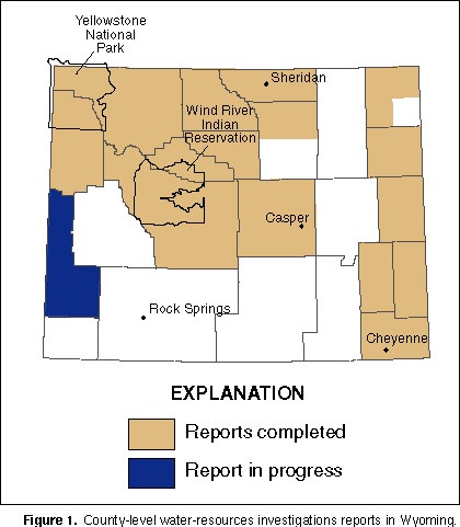
General information about the occurrence, variability, and quality of
surface and ground waters within political boundaries commonly is needed
for local water management. To meet that need, the USGS, in cooperation
with the Wyoming State Engineer, has conducted a series of county-level
water-resources investigations in Wyoming since the 1950's (fig. 1); the Lincoln County study is in
progress (1996). The USGS completed similar investigations of Yellowstone
National Park (1973) in cooperation with the National Park Service, and of
the Wind River Indian Reservation (1996) in cooperation with the Shoshone
Tribe, Northern Arapahoe Tribe, and the BIA. Results of the investigations
are used by all levels of government to manage and protect Wyoming's finite
water resources under ever-increasing demands. |

(Click on image for a larger version, 50K JPEG)
|
|
Figure 1. County-level water-resources investigations
reports in Wyoming. |
|
|
|
|
Where human activity meets rivers and streams, hydrologic and hydraulic
information about floodflows is needed. Since 1958, the USGS, mainly in
cooperation with the Wyoming Department of Transportation, has conducted a
series of integrated investigations to determine the flood characteristics
of Wyoming streams. USGS hydrologists use information from
streamflow-gaging stations to develop and refine procedures for estimating
the size of floods of a given frequency at unmeasured sites throughout
Wyoming. These procedures are being used by government agencies and
private engineering and natural-resource companies to delineate areas of
potential inundation, to determine the optimum size of highway bridges and
culverts for safety and cost effectiveness, and to plan drainage systems at
surface mines.
|
|
|
|
Geologic maps provide information useful for exploration and development of
minerals, as well as for planning and locating industrial and housing
developments. The USGS is funding geologic mapping of selected quadrangles
(1:24,000 scale) by the Wyoming State Geological Survey. Funds for the
mapping projects are administered by the USGS through its State Geologic
Mapping Program (STATEMAP). This Program is a component of the National
Mapping Act of 1992, in which States and the Federal Government share
equally in the cost of selected geologic mapping projects. The program in
Wyoming is in its third year. The current (1995) mapping project is the
Guernsey Quadrangle, which includes northeastern Platte and northwestern
Goshen Counties. This quadrangle is within the Hartville Uplift, where
there is active production of industrial minerals and decorative stone.
Past mapping projects include the Laramie, the Red Buttes, and the Howell
Quadrangles in the southeastern part of the State.
|
|
|
|
Although about 95 percent of the water used in Wyoming is from rivers and
streams, only ground water is available in many areas. The USGS,
principally in cooperation with the Wyoming State Engineer, has conducted
numerous small- and large-scale studies of the ground-water resource.
Examples include a statewide series of hydrologic atlases that provide
ground-water and related information for the major geologic basins of
Wyoming, quantitative studies of the availability of ground water for
irrigation and the estimated effects of future ground-water withdrawals,
and continuous, long-term monitoring of water levels and water quality in a
statewide network of observation wells. Large multi-State studies of
regional aquifers that are partly in Wyoming were sponsored by the USGS�the
Madison Limestone and the Northern Great Plains aquifer systems in
northeastern Wyoming, the High Plains aquifer in southeastern Wyoming, and
the Upper Colorado River Basin aquifer system in southwestern Wyoming.
|
|
|
|
|
|
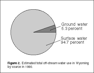
Every 5 years since 1950, the USGS has compiled water-use estimates for the
United States. Estimates for Wyoming for 1990 (fig. 2) include total water use, public supply,
domestic, commercial, irrigation, livestock, industrial, mining,
thermoelectric and hydroelectric power, and waste-water release. The
information may be useful to water-resource managers, State planners,
industries, and the general public as a source of data to use in economic
and resource allocation. |

(Click on image for a larger version, 33K JPEG)
|
|
Figure 2. Estimated total off-stream water use in Wyoming
by source in 1990. |
|
|
|
|
|
|
Although selenium is an essential element for animals and humans, excessive
amounts can have potentially adverse effects on fish, birds, and human
health. In Wyoming, areas where water flows over and through seleniferous
soil and rocks are of special concern, especially where water drains into
wildlife refuges, wetlands, lakes, reservoirs, and streams. |
As part of the U.S. Department of the Interior's National Irrigation
Water-Quality Program, the USGS, together with the Bureau of Reclamation,
the U.S. Fish and Wildlife Service, the BIA, and the Shoshone and the
Northern Arapahoe Tribes, conducted studies of three irrigation areas in
Wyoming�the Kendrick Reclamation Project near Casper, the Riverton
Reclamation Project, and the Wind River Indian Reservation. Samples of
water, bottom sediments, and fish and bird tissue were collected and
analyzed for selenium and other trace elements. Selenium concentrations in
the food chain exceeded threshold concentrations, which are known to cause
adverse effects in fish and aquatic birds, only in the Kendrick area.
Results of the studies are being used by local, State, and Federal agencies
to help evaluate potential cleanup options, irrigation practices, and
changes in land use in the Kendrick area.
|
|
|
|
USGS personnel frequently are asked to present exhibits and to give
presentations to schools and organizations. As part of a Partnership
Agreement with Cole Elementary School in Cheyenne, USGS personnel teach
science to the 5th grade class each week. The USGS, in cooperation with
the city of Evanston, created informational signs along the Bear River
Greenway.
|
|
|
|
|
|
The USGS is assisting the U.S. Air Force in studies of soil and water
contamination at F.E. Warren Air Force Base, Wyoming. Because of
contamination and the proximity of numerous suburban domestic wells, the
Base was placed on the National Priorities List by the U.S. Environmental
Protection Agency (USEPA) in February 1990. The USGS is characterizing the
hydrology to predict the movement of contaminants on and from the Base in
surface and ground water. The results of these studies are the basis for
assessments of the actual and potentially adverse effects that
contamination might have on human health and the environment and for the
design of cleanup options, if needed. |
Increased pesticide use has resulted in increased crop production but also
has raised concerns about the effects of pesticides on the environment and
human health. Ground water, in many cases the sole source for rural
residents, is particularly susceptible to contamination. The Wyoming
Department of Agriculture, in cooperation with other State and Federal
agencies, including the USGS, initiated the preparation of a State
pesticide management plan for the USEPA. The plan includes a pesticide-
monitoring program in selected agricultural areas to determine the extent
of pesticides in ground water. This information may be useful to State and
local entities that make decisions about pesticide use.
|
|
|
|
The geologic features and phenomena in the Yellowstone region in
northwestern Wyoming are the result of active volcanic and
mountain-building processes that have persisted for several million years.
Volcanic eruptions and large earthquakes have occurred many times in
Yellowstone's recent past and will likely continue to affect the region.
The USGS, in cooperation with the National Park Service and the University
of Utah, is studying past volcanic and seismic activity in Yellowstone and
monitoring signs of continued activity. These signs include frequent small
earthquakes, rapid uplift and subsidence of the ground surface, and
persistent, but ever-changing, hydrothermal activity. One goal is to
provide the scientific basis for timely warnings of any future volcanic and
earthquake activities.
|
|
|
|
|
|
The National Mapping Program of the USGS strives to ensure that map data in
graphic and digital form are available to the public through timely and
effective data collection and revision procedures. Among the most popular
and versatile products of the USGS are its 1:24,000-scale topographic maps
(1 inch on the map represents 2,000 feet on the ground). These maps show
natural and cultural features of the landscape, such as lakes and streams,
highways and railroads, boundaries, and geographic names. Contour lines
show the elevation and shape of terrain. Wyoming is represented by 1,922
maps at this scale, which are useful for civil engineering, land-use
planning, natural-resource monitoring, and other technical applications.
These maps have long been favorites with the general public for a wide
variety of outdoor uses. |
For many years, the USGS has worked with the Wyoming Geographic Information
Advisory Council (formerly the Wyoming State Mapping Advisory Council)
through the Wyoming State Engineer's Office to provide accurate map
products to the public at a nominal cost. Accomplishments include
accelerated completion of statewide coverage of 1:24,000-scale printed and
digital topographic maps, preparation of 1:100,000-scale digital maps for
identification of irrigated areas in the Wind River area and other parts of
Wyoming, and revised 1:24,000-scale paper and digital topographic maps that
represent the Cheyenne area.
|
|
|
|
The USGS, in cooperation with the Natural Resources Conservation Service
(NRCS), is producing 350 digital orthophotoquads (DOQ's) that will cover
the Wind River Indian Reservation in western Wyoming. A DOQ is a digital
image of an aerial photograph in which displacements caused by the camera
and the terrain have been removed. A DOQ combines the image
characteristics of a photograph with the geometric qualities of a map. The
Bureau of Land Management (BLM) and the BIA are participating in this
project by establishing horizontal control (land-surveyed data). The NRCS,
in cooperation with land-resource managers in Wyoming, will use the DOQ's
for conservation planning, habitat analysis, and soil surveys. The USGS,
in cooperation with the BLM, is producing 35 DOQ's that will cover the
Jackson Hole area. These DOQ's will be used by Federal, State, and local
agencies for planning and impact studies for the Snake River drainage area
in and around Jackson Hole.
|
|
|
|
Current, credible, understandable, and standardized information on the
location, quantity, and quality of the coal resources of the United States
is needed by Federal, State, and regional planners, as well as scientists
and industry. The USGS, in cooperation with the State Geological Surveys,
including the Wyoming State Geological Survey, initiated a study in 1975 to
develop the National Coal Resources Data System (NCRDS). The USGS provides
the central hardware, software, and analytical capabilities; the USGS and
the States contribute data and use the data bases. Currently (1996),
Wyoming and 21 other States, representing 98 percent of current U.S. coal
production, are participating in cooperative projects. The NCRDS data
bases provide baseline information that can be accessed for annual State
resource updates and used to meet many needs.
|
|
|
|
The Clean Air Act Amendments of 1990 created a renewed interest in locating
coals that have low concentrations of hazardous air pollutants, sulfur, and
ash. Coal of Tertiary age in Wyoming, Montana, and North Dakota has low
sulfur and ash contents, but detailed studies of the distribution of
hazardous air pollutants have only recently begun. USGS scientists have
developed models for the distribution of coal on the basis of the
environment that shaped and formed these deposits. The USGS, in
cooperation with the Office of Surface Mining and the Wyoming State
Geological Survey, is evaluating the models in anticipation of increased
coal production during the next two decades. This work is an important
step because most of the coal in Wyoming, Montana, and North Dakota is on
publicly owned land.
|
|
|
|
|
|
Recent geologic mapping by the USGS in the Jackson Hole area addresses
several issues important to local residents and visitors to this scenic
part of the State. The mapping project emphasizes three aspects of geology
in this area�the glacial history of the valley, the extent of recent
faulting, and the geology associated with 10 archeological sites around
Jackson Lake. The work is coordinated with and benefits Grand Teton
National Park, the Bureau of Reclamation, the Bridger-Teton National
Forest, and Yellowstone National Park.
Ever-increasing urbanization of the Snake River Valley in Teton County has
placed greater needs for accurate and reliable hydrologic and hydrogeologic
data and related interpretive investigations. The USGS, in cooperation
with the Teton County Board of Commissioners, the Teton County Natural
Resource District, the Wyoming State Engineer, and Grand Teton National
Park, is collecting data and investigating various aspects of ground- and
surface-water interchange and water-quality issues and is reevaluating the
ground-water resources within the Valley. This information may be used for
comprehensive water-resources management planning for the area. |
Gravel is used extensively as aggregate for asphalt-road surfacing. The
cost of transporting gravel from mine site to application site is a major
factor in the economics of road maintenance. The USGS, in cooperation with
the Teton County Planning Office, is conducting a study to determine the
availability and quality of gravel in the Jackson Hole area for road
surfacing in Teton County. Several gravel sites along the Snake River near
Jackson have been selected for the study. Availability includes an
assessment of the quantity of gravel to a depth of 20 feet below land
surface and the presence and depth of the water table. Quality includes
gravel size distribution, sediment content, presence of fractures in the
gravel, and quartzite content of the gravel.
|
|
|
|
|
|
Since 1895, the USGS has collected continuous, intermittent, and
single-measurement surface-water data at more than 2,000 sites throughout
Wyoming (fig. 3). Water-quality data have
been collected at more than 1,600 sites. About 170 surface-water stations
currently (1996) are in operation. The data-collection program is done in
cooperation with many local, State, and Federal agencies. These data are
used for the daily administration and management of water resources,
interpretive hydrologic studies, determining the extent and severity of
droughts, characterizing and predicting conditions during floods, and
monitoring the effects of human activities on streamflow and water
quality. |

(Click on image for a larger version, 66K JPEG)
|
|
Figure 3. Surface- and water-quality data-collection
sites in Wyoming.
| |
|
|
|
The Earth Science Information Centers (ESIC's) provide information about
USGS programs, products, and technological developments to the public. The
ESIC in Laramie was established under a cooperative agreement between the
USGS and the Wyoming State Geological Survey at its Cartographic
Information Center. As part of the National ESIC network, the ESIC in
Laramie provides information on such earth science topics as cartography,
geography, digital data, remote sensing, geology, geophysics, geochemistry,
hydrology, geohydrology, aerial photography, and land use in Wyoming. The
USGS supports the ESIC in Laramie with reference materials, technical
assistance, training and outreach activities, and access to USGS data
bases.
|
|
|
|
Cooperative activities include water-resources data collection,
interpretive water-availability and water-quality studies, mineral-resource
assessments, and mapping. When local and State agencies are involved,
activities typically are funded on a matching-funds basis. In addition to
agencies already mentioned, the USGS cooperates with the cities of Cheyenne
and Lander, the Midvale Irrigation District, the Fremont County Weed and
Pest Control District, the U.S. Army Corps of Engineers, the Wyoming Water
Development Commission, the Wyoming Department of Environmental Quality,
the Lingle-Fort Laramie Conservation District, the Shoshone and Heart
Mountain Irrigation District, the South Goshen Conservation District, the
Star Valley Conservation District, and the Saratoga-Encampment-Rawlins
Conservation District. |