This document is also available in pdf format: ![]() fs-051-99.pdf
fs-051-99.pdf
This document is also available in pdf format:
fs-051-99.pdf
The U.S. Geological Survey (USGS) is the Nation's principal earth- and biological-science agency. The USGS provides long-term monitoring, integration, and interpretation of data, and scientific research in partnership with State and county governments, municipal public-works departments, public-health agencies, water and sanitation districts, Indian agencies, and other Federal agencies. This fact sheet describes some of the current USGS activities in Wisconsin.
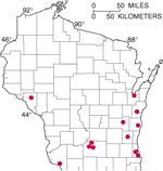
| Figure 1. Nonpoint pollution monitoring sites. |
Much of Wisconsin is faced with the growing problem of deteriorating water quality in streams because of increasing runoff from nonpoint pollution sources. The State has approximately 24,000 dairy farms from which sediment, nutrients, and pesticides can enter surface-water bodies. Additionally, runoff from tilled cropland and urban areas can add more sediment and pesticides to streams. Runoff of this type generally decreases dissolved oxygen in the stream water, and thus is detrimental to the health of fish and other aquatic organisms. The runoff also adds unwanted sediment and chemicals to the water that must be dealt with by water users downstream. The Wisconsin Department of Natural Resources (DNR) has proposed, and is implementing, several "Best Management Practices" (BMP) projects in an attempt to reduce some of the problems associated with this nonpoint pollution. The USGS has several studies directed toward evaluating the effectiveness of these DNR projects. The objectives of some of the USGS studies are to determine differences in the quality and quantity of surface-water runoff from several areas of different pasture-management practices, both before and after implementation of the BMPs. Other study objectives are to measure the amounts of solids and nutrients in urban runoff, and to measure runoff volumes and water quality from several pastures. The map (fig. 1) shows the locations of all of the monitoring sites, but it does not identify their purposes.
The objectives and the benefits of the results of the USGS studies are important to the future quality of the State's rivers and streams. The USGS documentation of before-and-after BMP applications can identify which practices work best under each type of pre-existing condition. After thorough study, the DNR will be able to protect stream-water quality by recommending the BMP for individual sites.
Fishing is a major pastime for 50 million Americans, and recreational fisheries have come to rely heavily on fish produced in public hatcheries. If hatchery-raised fish contract diseases, medicinal drugs regulated by the Food and Drug Administration (FDA) are required to restore their health. Only three drugs and one anesthetic are legally available to treat many of the fish species cultured by public aquaculture, and additional drugs are needed to support the hatcheries. The generation of data necessary to gain approval of a drug is costly. Private drug and chemical companies cannot justify the capital investment to develop aquaculture drugs. To address this problem, a partnership was formed between the States, Federal aquaculture advocacy agencies, and private drug companies to develop seven drugs and one anesthetic for public aquaculture. The Federal-State Drug Approval Partnership, a project of the International Association of Fish and Wildlife Agencies, represents the largest and most comprehensive effort ever undertaken on behalf of public aquaculture. Because of its expertise in this area, the USGS Upper Midwest Environmental Sciences Center in La Crosse has the leadership role to provide scientific oversight and coordination for the project and to conduct a variety of studies required by the FDA to support the drug approvals. Research has been completed that, when accepted by FDA, will allow the use of three new waterborne drugs for all 55 cultured freshwater fishes. When the project is completed (now scheduled for 2002), approvals will be obtained for five waterborne drugs, two oral drugs and one anesthetic. Supplied with a newly stocked medicine chest, public aquaculture facilities across the country will be able to produce the many species required to support America's popular recreational fishing activities.
Background geochemical surveys describe the concentrations of major and trace chemical elements and their natural variations across wide areas and between various earth materials within individual areas. This information is essential for assessing the effects of natural and human-induced chemical signatures on the environment and human health. This ongoing study is exploring methods needed to conduct background evaluations in glaciated areas, while assessing the background geochemical aspects of the Chequamegon National Forest and Isle Royale National Park. The study is in collaboration with the US Forest Service, which is concerned with land-use decisions in the Forest; the Bureau of Land Management, which anticipates writing an Environmental Impact Statement on the Bend massive sulfide deposit within the Forest; the National Park Service, which is concerned with factors that may be contributing to high mercury levels in fish, such as mercury levels in soils and glacial material around known mineralized areas; the Wisconsin Geological and Natural History Survey, which has expertise on the glacial geology of the region and geology of Pleistocene deposits in the project area; and the University of Wisconsin/Wisconsin Dept. of Natural Resources, which is dating and analyzing lake sediment cores from the mercury-impacted lakes in the National Park.
The USGS has developed a strategy to help identify the 7.5-minute topographic maps that are in highest demand and that need revision. This plan uses monthly map sales as one criterion to determine the demand and to set priorities in the map revision process. Those maps that need to be revised and are in high demand will be authorized. In Wisconsin, the Milwaukee, Wauwatosa, and Greendale 1:24,000-scale topographic maps will be revised using this strategy.
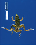
| Figure 2. Deformed frog captured during a study of deformities and disease in amphibians. |
The USGS's National Wildlife Health Center, in Madison, provides Federal and State land-management agencies with information, technical assistance, and research on national and international wildlife disease and health issues. USGS scientists have forged strong partnerships with several Wisconsin programs including the University of Wisconsin-Madison, University of Wisconsin-Stevens Point, the DNR, and private entities such as the International Crane Foundation. This unique facility is equipped with state-of-the-art disease-containment laboratories designed to meet the criteria established by the Centers for Disease Control and the National Institutes of Health for working with all but the most infectious agents. The Center has a national mission to monitor and assess the impact of disease on wildlife populations; investigate the ecological relationships leading to the occurrence of disease in freeranging wildlife; and provide on-site support for wildlife disease emergencies, as well as guidance, training, and technical information for reducing wildlife losses when outbreaks occur. Current Wisconsin activities include mortality investigations of wolves, bald eagles, and trumpeter swans for the Wisconsin DNR; collaborative studies with the University of Wisconsin and the Wisconsin DNR on the causes of deformities and disease outbreaks in frogs (fig. 2) and salamanders; investigation of an exotic waterfowl parasite in central Wisconsin's Shawano Lake; and the assessment of fishing sinkers as a cause of lead poisoning in fish-eating birds.
USGS research in the late 1980's identified widespread mercury contamination of game fish from lakes in Wisconsin. In most cases, the affected lakes were remote and the source of mercury was not apparent. Careful study showed that the dominant source of the mercury was atmospheric deposition, and that long-range transport from point sources (for example, coal-burning and waste-incineration facilities) were the primary contaminant sources. This research was the first of its kind, and it led to the development of expertise in the specialized field of the chemistry of environmental mercury. After completion of the work in Wisconsin, it was shown that mercury is a global pollutant, and that all aquatic ecosystems are affected by mercury contamination to some degree. Highly specialized sampling and analytical methods usually are required to quantify the extremely low levels of mercury found in most environmental samples (water, sediment, and tissues). Current research activities are focused toward determining what differentiates sensitive ecosystems, in which accumulation of mercury in the food web is acute, from those that are more buffered from this problem. The USGS Mercury Research Laboratory, in Middleton is participating in studies of mercury contamination of aquatic ecosystems across the conterminous U.S. and in Alaska and Hawaii. The overall objective of this work is to identify those factors that control mercury contamination of food webs, including mercury loading, landscape effects (watershed size, wetland density, climate, geology), and chemical effects (pH, dissolved organic carbon, sulfate). The mercury research team conducts these studies in collaboration with other Federal and State agencies and with private research laboratories.
This USGS-led study is intended to provide the information necessary to complete a qualitative (or, where possible, quantitative) regional or national mineral-resource assessment; address regional land-use questions, mineral development and minerals-related environmental issues; determine those areas for which information is lacking and need special attention; and provide regional datasets for incorporation in national databases. Toward this effort, the project has recently released a new, digital geologic map of the Great Lakes Region, and is acquiring new aeromagnetic data for southern Wisconsin. Current collaborators include the Minnesota Geological Survey; the Minnesota Department of Natural Resources; the Wisconsin Geological and Historical Survey; the University of Wisconsin-Oshkosh; the University of Western Illinois; the Department of Terrestrial Magnetism, Carnegie Institution of Washington; and the University of Minnesota-Duluth. Clients include the DNR, the Minnesota Department of Natural Resources, the Wisconsin Recycling Market Development Board, the U.S. Department of Agriculture Forest Service, the National Park Service, and the minerals industry.
New aerial photographs of Wisconsin are being obtained by the National Aerial Photography Program (NAPP). The USGS, through the NAPP steering committee (which includes representation from many Federal natural-resource agencies), has contracted to acquire the remainder of the 1:40,000-scale leaf-off, black-and-white photographs that were begun in the spring of 1998. Complete statewide coverage may take as long as 3 years because of weather conditions and a short flying season. When the project is complete, the photographs will be used by the USGS for revision of maps and production of digital orthophotos (DOP). A DOP is a computer-generated image of an aerial photograph that has the geometric qualities of a map. The USGS and the State Cartographer's Office of Wisconsin are working together to facilitate the completion of DOP coverage of the State. One proposal is to use existing DOP's that were made for use by cities or counties and to reformat them to comply with USGS DOP quarter-quadrangle standards. The State Cartographer's Office and the USGS are investigating whether those DOP's can be converted into the USGS digital orthophoto quadrangle format at a cost savings for all concerned.
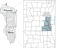
Southeastern Wisconsin has one of the most rapidly growing populations of the State, and in 1996 the area contained about 37 percent of the State's population. The economic growth and urban development of this area are partly due to the abundant water supply. Lake Michigan is the source for about 70 percent of the water supply, mainly for the lake-shore counties of Ozaukee, Milwaukee, Racine and Kenosha, which are principally in the Great Lakes Basin (fig. 3). The counties of Washington, Waukesha, and Walworth (in the Mississippi River Basin) rely on ground water for most of their needs because of the strict legal limits on the transfer of water from the Great Lakes basin to the Mississippi River Basin.
Because substantial economic growth is occurring and probably will continue in the areas that rely on ground water, there is a need for better management of ground-water resources. If it is assumed that the increase in ground-water use will be proportional to increases in population, then ground-water use might be expected to increase from about 93 Mgd (million gallons per day) in 1995 to about 140 Mgd by the year 2020. Water-level declines in the deep aquifer over the last 50 years range from 6 to 10 feet per year. Cones of depression centered on Milwaukee, Waukesha, and Chicago have intersected so that pumping in one area affects water levels in other areas.
Early researchers generalized the deep ground-water system in Southeastern Wisconsin as a "sandstone" aquifer comprising Cambrian-Ordovician age sandstone and dolomite, confined by an over-lying thick shale formation. Later studies split the sandstone aquifer into several aquifers and confining units. Although several ground-water flow models have been developed, no attempt has been made to simulate the interaction of the shallow aquifers, which consist of dolomite and unlithified materials, with the deeper ground-water systems. The interconnection and relation between the shallow and deep ground-water systems in the Southeastern Wisconsin is not well understood, and requires further evaluation.
Because of the complexity of the ground-water system, it probably is most effectively studied by the development and application of a numerical flow model in which the system is represented by multiple aquifers and confining units. Although most existing high-capacity wells are completed in the sandstone aquifer, it is likely that a higher proportion of future water-supply wells will be installed in the shallow aquifers. This shift is expected not only as a way of limiting the excessive drawdown in the deeper system, but also as a way to blend deeper water characterized by increasing radium and salt concentrations with lower-concentration shallow water.
| Figure 3. Area of intense ground-water study in the seven southeastern counties of Wisconsin. |
Long-term management and protection of the entire ground-water resource requires an understanding of the interactions between the multiple aquifers underlying the region. A planned new study (fig. 3) conducted by the USGS in cooperation with the Wisconsin Geological and Natural History Survey and the Southeastern Wisconsin Regional Planning Commission is intended to create an information base and a better conceptual understanding of the ground-water flow systems, both shallow and deep, and their response to urban development and water use; develop and refine management tools (conceptual and numerical models) that will be useful in water-resource management decisionmaking on a continuing basis and; use these tools to evaluate proposed management applications to prevent or minimize these adverse effects of urbanization and ground-water withdrawals.
Ground-water flow model simulation results and information will be useful to a wide variety of Federal, State and local agencies. The study is intended to provide needed information and guidance on potential management strategies to the Southeastern Wisconsin Regional Planning Commission, the DNR and municipal water utilities.
|
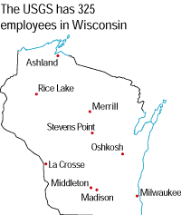
USGS office locations
|
USGS State Representative
USGS Home Page
Reports and products |