
|
|
|
|
|
"Crater Lake partially fills a 1,200-meter deep caldera, a depression formed by collapse of ancestral Mount Mazama during the violent eruption of 50 cubic kilometers of magma, or molten rock, about 7,700 years ago (6,845 +/- 50 14C years before present). By comparison, Mount St. Helens in 1980 erupted about half a cubic kilometer of new magma. Geologic history shows that catastrophic events of this kind can repeat. Are volcanic eruptions likely again at Crater Lake? One of the approaches U.S. Geological Survey scientists are using to answer this important question is to unravel the geologic history of the Crater Lake caldera floor." Young calderas pose a number of hazards for human activity
Calderas filled with water can produce tremendous flooding in the immediate vicinity if the caldera wall fails, as happened to Aniakchak Crater in Alaska when its rim was breached. Crater Lake shows no signs of imminent crater-wall failure: the last major wall failure occurred over 7,500 years ago, after the formation of the subaerial central platform of post-caldera lava flows, but before the lake water began accumulating. The Chaski slide, one block of which forms a prominent bench east of Crater Lake Lodge, was the last major landslide event and carried debris to the center of the caldera floor. Water-filled craters or calderas can release very large quantities of CO2 as happened at Lake Nyos, Cameroon, where hundreds of villagers in the vicinity of the Lake died of asphyxiation. Crater Lake, however, produces some circulation in its bottom half from hydrothermal activity on the caldera floor and strong circulation throughout from normal atmospheric influences. Moreover, sediment from the lake bottom shows no indication of the presence of gas, and the lake itself is surprisingly well-oxygenated, considering its depth. There is no evidence that Crater Lake is likely to turn over, as did Lake Nyos, and release large amounts of CO2.
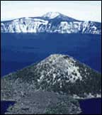
Understanding the history and evolution of calderas may help scientists predict when and where disasters are likely to occurThe interdisciplinary study of the Crater Lake caldera floor required extensive logistical assistance from the National Park Service and collaboration with scientists from Oregon State University in use of underwater vehicles. U.S. Geological Survey (USGS) scientists determined the geologic history of Crater Lake itself through detailed studies of the caldera and the Pacific ocean floor. The climactic eruption of Mount Mazama resulted in deposition of pumice and ash over more than a million square kilometers of the Pacific Northwest. Soon after, ash deposited in the Columbia River drainage basin was transported westward from the Pacific coast up to 700 kilometers offshore on the northeast Pacific ocean floor by turbidity currents along deep-sea channels. Collapse of the former volcanic edifice along a ring fracture system, forming the caldera, occurred during the eruption and compensated for the ejection of the 50 cubic kilometers of magma. Part of the erupted material fell within the developing caldera to form a plug of intracaldera tuff that may be as much as 2 kilometers thick. The basin that now contains Crater Lake is the resulting collapse caldera, 1,200 meters deep and 8 to10 kilometers in diameter at the rim. In a matter of only a few hundred years, the caldera was partially filled, first with landslide debris from the walls and later with post-caldera volcanic rocks, water, and lake sediment. USGS workers used Crater Lake's well-preserved, detailed geologic history to develop a genetic model of small caldera evolutionPost-caldera volcanic vents, geothermal features, and buried steam-explosion (phreatic) craters detected by seismic surveys collectively outline a ring fracture zone along which Mount Mazama subsided. These features began to form after caldera collapse about 7,700 years ago, but before the caldera filled with water to essentially its present level over the following 300 years. The large central platform of subaerial lava flows and domes erupted before the lake was present. Radiocarbon dates taken from lake-bottom organic matter indicate that the lake covered the central platform within at least 150 years of the caldera collapse. Wizard Island, one of the two major caldera-floor volcanic cones, erupted additional material into the lake as it finished filling. These subaqueous Wizard Island deposits accumulated to a height 70 meters below today's lake surface, and the subaerial island continued to grow nearly 250 meters above the present lake surface. Merriam Cone, the other large volcanic cone, erupted completely underwater, rising more than 400 meters above the caldera floor, but it remains 200 meters below the present lake surface.
Evidence for the timing of these events is found in detailed analysis of sediment sources and of radiocarbon dates from the central platform deposits. The age of the central platform sediment shows that the last main volcanic event, extrusion of a small rhyodacite dome east of Wizard Island, happened about 5,000 years ago. Investigations also show that the early lake sediment contained pollen from gradual re-establishment of post-eruption forest surrounding the lake as well as primitive diatoms that lived in the early, more hydrothermal water. Warmer and drier climatic conditions existed during the lake's early history, but a colder and wetter neoglacial climate has dominated for the past several thousand years. There is evidence that large slope failures may have been triggered while volcanic and seismic activity continued up to 5,000 years ago. Since then, the geologic history of the caldera floor is marked by a distinct absence of volcanic activity. Mass wasting from the caldera walls continues, but on a much reduced scale. Lake bottom sediments now cover the chaotic subaerial debris wedges and volcanic deposits laid down as the lake was forming. This lake sediment blanket on the floor is well-bedded with a variety of sediment sizes ranging from gravel at the edge to very fine sand toward the lake center. Organic-rich muds also have accumulated on the submerged volcanic features. The lake sedimentation rate is currently high, but remains considerably lower than that found during the subaerial mass wasting that occurred before the lake formed. Other USGS studies at Crater Lake, either published in scientific journals or in progress, include research on development of the shallow magma chamber which produced the climactic eruption, eruptive processes and caldera collapse as indicated by features of the volcanic deposits, and the early history of Mount Mazama and the many smaller volcanoes in the Crater Lake area. In addition, scientists from the USGS Cascades Volcano Observatory periodically make geodetic measurements and look for tilting or swelling of the caldera area that might forewarn of renewed volcanic activity.
|
Related Publications:
Mount Mazama and Crater Lake: Growth and Destruction of a Cascade Volcano - USGS Fact Sheet 092-02 Volcano and Earthquake Hazards in the Crater Lake Region, Oregon - USGS Open File Report 97-487 Related Links: Oregon State University National Park Service Description:
Mount Mazama Volcano and Crater Lake Caldera, Oregon Maps, perspective views, and fly-over movies of Crater Lake Crater Lake Seismicity Information
Crater Lake National Park |