 |
|
|
||||
| Fact Sheet 077–95 |
| About USGS / Science Topics / Maps, Products & Publications / Education / FAQ |
Aeromagnetic survey data collected by helicopter over hazardous waste sites can be used to map the distribution of buried metallic (ferrous) objects at these sites, including drums and scrap metal. Thorough knowledge of the locations and nature of hazardous waste containers and contaminated objects is needed prior to the start of remediation efforts. Non-invasive geophysical techniques such as the aeromagnetic method provide the best way to obtain this knowledge. The U.S. Geological Survey (USGS) not only has experience in processing and interpreting aeromagnetic surveys of this type but also offers aid in the design and monitoring of contracts for such surveys.
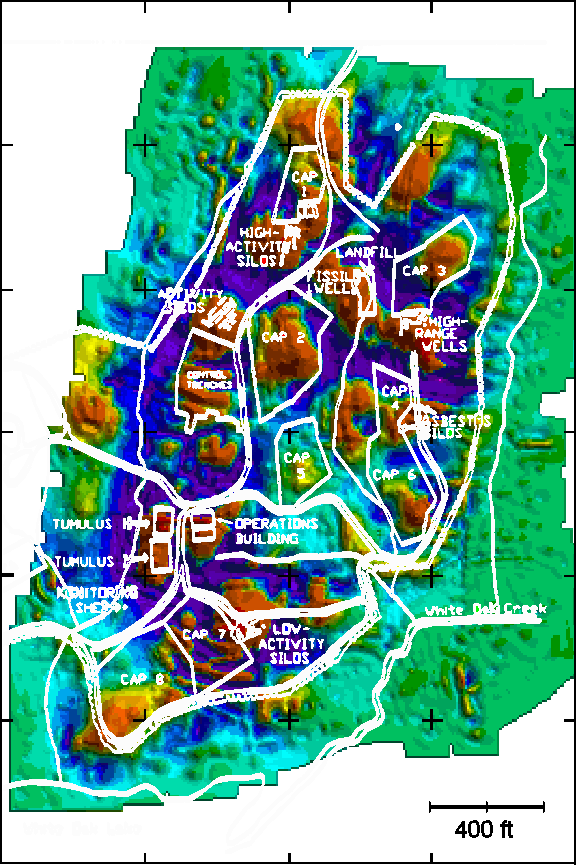
Figure - Oak Ridge Reservation, Oak Ridge National Laboratories, Oak Ridge, Tennessee.
Distribution of magnetic materials at a hazardous waste site as interpreted from aeromagnetic data. Exposed and buried ferrous metallic materials appear as yellows, oranges, and reds. A site plan showing known structures, such as impervious caps covering pit and trench areas, is superimposed in white. Note that magnetic materials appear in several areas unassociated with known structures. These areas, which may be previously undocumented dump sites, require further investigation.
For further information please click here.
The USGS has 50 years of experience in the development and application of the aeromagnetic method. In particular, the USGS has taken a leading role in software development for processing, interpreting, and displaying helicopter aeromagnetic survey data. Often existing software must be modified or new software developed to address the individual needs of a particular survey. Examples of processing steps include (1) taking magnetic field measurements collected along flight lines at varying altitudes and reducing them to a common level above the waste site and (2)interpreting the measurements to produce a map or cross sections showing the distribution and characteristics of magnetic material within the site.
When used to map the distribution of ferrous objects at known hazardous waste sites, aeromagnetic survey data can confirm available records of the site contents or reveal discrepancies between the data and these records. Aeromagnetic surveys are also a cost effective way to map large areas suspected of containing unrecorded hazardous waste dumps. In either case such surveys will leave the sites completely undisturbed. Aeromagnetic surveys can also detect geologic features such as faults, dikes or sills, and volcanic flows that can act as conduits or barriers to groundwater flow through the site. The aeromagnetic survey data, in conjunction with other geophysical and geological data, must be carefully processed and interpreted in order to accurately characterize the site.
Jeffrey D. Phillips
U.S. Geological Survey
Box 25046, MS 964
Denver Federal Center
Denver, Colorado 80225
(303) 236-1206
Fax: (303) 236-1425
EMail: jeff@usgs.gov
| AccessibilityFOIAPrivacyPolicies and Notices | |
| |
|