 |
|
|
||||
| Fact Sheet 078–95 |
| About USGS / Science Topics / Maps, Products & Publications / Education / FAQ |
Gridded geophysical data sets for the conterminous United States are available on CD-ROM from the U.S. Geological Survey (USGS). The data sets include magnetic anomalies; Bouguer gravity anomalies; isostatic residual gravity anomalies; uranium, thorium, and potassium gamma-ray measurements; and topography with and without bathymetry. The magnetic anomaly and gamma-ray data sets are gridded at a 2- kilometer grid interval; the gravity anomaly and topographic-bathymetric data sets are gridded at a 4-kilometer grid interval. The gridded data are provided in both ASCII and PC-binary formats. Potential-field geophysical software, included with the data sets, can be used to display, process, and interpret the gridded data.
Magnetic anomalies are produced by variations in the distribution of iron minerals, usually magnetite, in the rocks of the Earth's crust. Igneous and metamorphic crystalline rocks can be very magnetic. By comparison, sedimentary rocks are usually nonmagnetic. Magnetic anomalies therefore provide a way of mapping exposed and buried crystalline rocks.
Gravity anomalies are produced by density variations within the rocks of the Earth's crust and upper mantle. Mapping of these density variations is the primary use of gravity anomalies. Gravity measurements made on the surface of the Earth must be corrected in various ways before they can be made into an anomaly map.
The free-air correction adds to the measured gravity the predicted difference in gravity between sea level and the elevation of the observation. The simple-Bouguer correction subtracts the predicted effect of the mass between the observation and sea level, using a uniform slab of constant density to model the mass. The complete-Bouguer correction adds the predicted effect of constant-density topography within 166.7 km of the measurement location. A gravity reference field is subtracted from the corrected measurements to produce the free-air, simple-Bouguer, or complete-Bouguer anomaly.
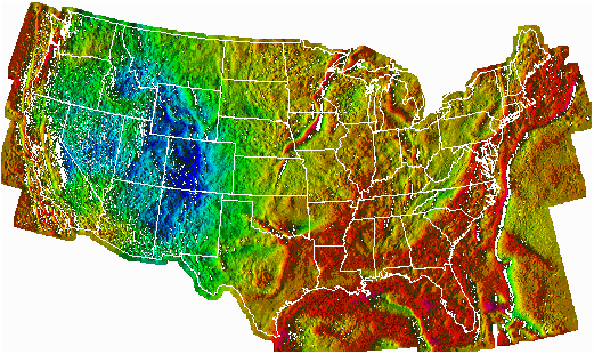
Figure - Color shaded-relief map showing the complete-Bouguer gravity anomaly data for the conterminous United States (onshore) and free-air gravity anomaly data offshore.
Red shades indicate areas of high gravity values produced by high average densities in the Earth's crust and upper mantle; blue shades indicate areas of low gravity values produced by low average densities. Illumination is from the west.
The grid of Bouguer gravity data for the conterminous United States and adjacent marine areas was constructed from complete-Bouguer gravity anomaly values onshore and free-air gravity anomaly values offshore. Because the Bouguer anomaly equals the free-air anomaly at sea level, there is no discontinuity in the gridded data at the shoreline.
Isostatic residual gravity anomaly maps are produced by subtracting long-wavelength anomalies, produced by masses deep within the crust or mantle, from the Bouguer anomaly map. Isostatic residual gravity anomaly maps therefore reveal more clearly than Bouguer anomaly maps the density distributions within the upper crust that are of interest in many geologic and tectonic studies.
Aerial gamma-ray surveys measure the gamma-ray flux produced by the radioactive decay of the naturally occurring elements U-238, Th-232, and K-40, in the top few (as much as 50) centimeters of rock or soil. When the gamma-ray system is properly calibrated, the data can be expressed in terms of the estimated concentrations of these radioactive elements. The element concentration data are useful in geologic studies to identify (1) the lithology of rock outcrops, (2) areas of high-grade metamorphism or hydrothermal alteration, (3) areas of possible uranium mineralization, and (4) areas where high levels of radon gas in the soil or high gamma-ray exposure levels may pose health risks.
Topographic and bathymetric data are used in the reduction and interpretation of magnetic anomaly and gravity anomaly data and in the construction of geologic and topographic maps.
The gridded data sets are available on CD-ROM (DDS-9) from:
USGS Information Services
Box 25286, Building 810
Denver Federal Center
Denver, Colorado 80225
(303) 202-4200
Jeffrey D. Phillips
U.S. Geological Survey
Box 25046, MS 964
Denver Federal Center
Denver, Colorado 80225
(303) 236-1206
Fax: (303) 236-1425
EMail: jeff@usgs.gov
| AccessibilityFOIAPrivacyPolicies and Notices | |
| |
|