This document is also available in pdf format:![]() fs-019-99.pdf
fs-019-99.pdf
| As the Nation's largest earth-science and civilian mapping agency, the U.S. Geological Survey (USGS) works in cooperation with many Federal, State, and local organizations to provide reliable and impartial scientific information to resource managers, planners, and others throughout the country. This information is gathered in every state by USGS scientists to minimize the loss of life and property from natural disasters, contribute to the conservation and sound management of the Nation's natural resources, and enhance the quality of life by monitoring water, biological, energy, and mineral resources. This Fact Sheet describes some of the USGS activities in Louisiana. |
The Atchafalaya Basin (fig. 1) in south-central Louisiana is the largest river-bottomland hardwood swamp in the Nation. The USGS, in cooperation with the U.S. Army Corps of Engineers (USACE), is monitoring the basin to determine environmental effects of flood-management practices. Physical and chemical-related properties being monitored include continuous velocity and stage, specific conductance, pH, dissolved-oxygen (DO) concentrations, water temperature, and sediment deposition.
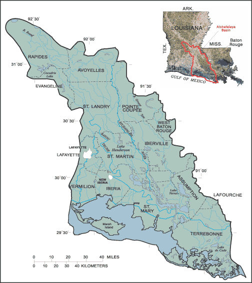 |
Figure 1. Atchafalaya Basin, Louisiana |
The USGS Cooperative Fish and Wildlife Unit, at Louisiana State University in Baton Rouge, has been monitoring the basin to assess the health of the fin fisheries and commercial crawfish farms. In addition, scientists are analyzing digitized historical maps of the basin to assess sedimentation patterns. Information from this study will be useful in designing and implementing management plans for the Atchafalaya Basin.
Louisiana has 25 percent of the forested wetlands and 40 percent of the coastal wetlands in the 48 contiguous States but accounts for 80 percent of wetlands losses. The State's coastal area (wetlands, estuaries, and barrier islands) is under stressed conditions resulting from a complex array of adverse natural environmental processes and human-related activities. Every year, the Louisiana coastal area, one of the world's most productive ecosystems, loses as much as 20 to 25 mi2 (square miles) of land.
About 1,000 to 1,500 mi2 of Louisiana's coastal wetlands have been converted to open water during the past half century. The processes and activities that have contributed to this conversion include long-term erosion and land subsidence (sinking of the land) caused, in part, by compaction of Mississippi River Delta sediments and by large storms that strike the area about every 5 years, rising sea levels, changes in human population, energy development, flood control, and maintenance of navigation channels. As wetlands, estuaries, and barrier islands vanish, the State loses important natural buffers protecting New Orleans and other populated coastal areas from storms and flooding.
The USGS is assessing changes in Louisiana's coastal environment for improved understanding of the contributing processes and activities to assist Federal, State, and local managers and planners in developing and utilizing restoration and preservation methods. The USGS National Wetlands Research Center (NWRC) in Lafayette provides basic information and spatial analysis of data from small-scale restoration projects (fig. 2) throughout the Mississippi River Delta. The restoration projects are supported through the Coastal Wetlands Planning, Protection and Restoration Act of 1992 and managed by the Federal and State Wetlands Task Force. The NWRC also studies vigorous "super plants" that could lessen coastal erosion, restoration of threatened coastal prairie habitats, effects of hurricanes on wetlands and barrier islands, and changes in global climate.
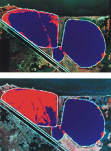 |
Figure 2. Example of a successful restoration project being monitored by the USGS, showing before (above) and after (below) restoration of the LaBranche wetland site just west of New Orleans, Louisiana, and adjacent to the Mississippi River. |
The USGS, in cooperation with the Louisiana Department of Natural Resources
(DNR) and the Louisiana Department of Wildlife and Fisheries, is monitoring
surface water along the Louisiana coast to provide Louisiana with vital information
during hurricanes. The data also are used to manage freshwater-diversion and
coastal restoration projects by the State and the USACE.
The USGS is participating in the evaluation of an area referred to as a hypoxic or "dead" zone that appears in the Gulf of Mexico; the area extends westward from the mouth of the Mississippi River along the Louisiana coast. Hypoxia exists when DO concentrations in the bottom water decrease to levels that are insufficient to support marine life such as fish, shrimp, and crabs. The depletion of DO occurs nearly every spring and summer in response to inflow of nutrient-enriched water from the Mississippi River into the Gulf of Mexico. The nutrient-enriched water encourages the vigorous growth of algae that, as they die and decompose, deplete the DO supply. Under hypoxic conditions, most animals move to an area having higher DO concentrations; animals unable to move, such as those living in the mud, die if the hypoxia persists.
In relation to hypoxia monitoring, the USGS monitors nutrient transport in the Mississippi River as part of the National Stream-Quality Accounting Network and the Midcontinent Herbicide Programs. Data and interpretations from these programs provide the only nutrient-load estimates for water transported by the Mississippi River into the Gulf of Mexico. Furthermore, the USGS is a member of the Committee of Environment and Natural Resources, White House Office of Science and Policy, that is evaluating hypoxia in the Gulf of Mexico.
The USGS is conducting studies in the Acadian-Pontchartrain Study Unit, http://la.water.usgs.gov/nawqa, as part of the National Water-Quality Assessment Program. This program is designed to describe the status and trends in the quality of the Nation's ground- and surface-water resources and to provide a sound understanding of the natural and human factors that affect the quality of these resources.
The study unit, which covers about 26,000 mi2 in southern Louisiana and southwestern Mississippi, includes many large drainage basins and Lake Pontchartrain, one of the Nation's largest estuaries. About 3.1 million people live within this study unit.
Water-quality concerns in the study unit include the following:
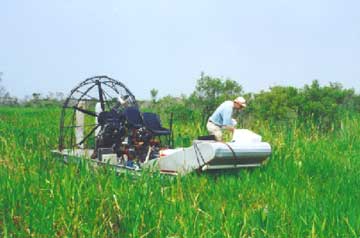 |
Figure 3. USGS scientist sampling flotant marshes at Jean Lafitte National Historical Park and Preserve, south of New Orleans, Louisiana. |
Through the Acadian-Pontchartrain study, the USGS and the Louisiana Department
of Environmental Quality (DEQ) are sharing data to evaluate the occurrence of
mercury in fish tissue and to further understand the transport and fate of mercury
in the environment. The USGS has analyzed bottom-material samples for grain
size and organic carbon and provided fish tissue samples to DEQ for analysis
of mercury.
Louisiana leads the Nation in property damage caused by floods. To help reduce
future losses, the USGS, in cooperation with Federal, State, and local agencies,
operates a statewide real-time flood monitoring system to measure river stage
and transmit data. During floods and hurricanes, this information is passed
on to the appropriate emergency response agencies and the news media through
the Louisiana Office of Emergency Preparedness (LOEP), and the USGS provides
on-site assistance at the LOEP. The information also is available on the Internet
at http://la.water.usgs.gov.
During floods in the Amite River Basin near Baton Rouge, the USGS records real-time,
river-stage data on a local voice-mail system (a prototype of a planned statewide
system), which is accessible by telephone. Additionally, the USGS, in partnership
with the Louisiana Department of Transportation and Development (DOTD) and the
Amite River Basin Drainage and Water Conservation District, has produced and
widely distributed a flood-tracking map for this basin. The map can be used
to track rising river stages and, by using hydrologic information obtained through
the voice-mail and news media, to make decisions about evacuation and protection
of personal property. The map is available at local public libraries and information
centers and on the Internet at http://la.water.usgs.gov.
The USGS National Oil and Gas Assessment is a program designed to assess the
undiscovered oil and natural gas resources in the United States. Ongoing USGS
investigations in Louisiana include developing the sequence stratigraphy of
the Tertiary of southern Louisiana, the geologic characterization of the Austin
Chalk, and porosity evolution of deep Tuscaloosa sandstones, all of which provide
geologic information for further assessment activities.
In 1995, the USGS determined that the Austin Chalk is our Nation's largest, onshore domestic unconventional, continuous-type oil resource. More recently, exploration and production in frontier areas of Texas and Louisiana (fig. 4) have shown that the Austin Chalk has additional potential as a continuous-type deep-gas resource mostly to the east and downdip of existing oil plays.
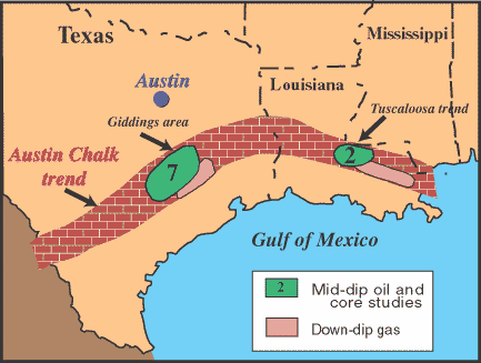 |
Figure 4. The Austin Chalk trend in Texas, Louisiana, and Mississippi. |
The USGS is studying the geologic framework, stratigraphy, lithology, and the
burial and production histories of the Austin Chalk to assess the quantitative
estimate of this large domestic resource. Distribution of the Austin Chalk from
framework studies will assist in outlining geographic extent, among other factors,
to identify current and frontier exploration target areas.
The assessment of Louisiana's coal deposits is part of the USGS National Coal
Resource Assessment. This program is designed to identify and characterize coal
zones that will provide the bulk of the Nation's coal-derived energy during
the next few decades. The coal mined in Louisiana is used as fuel for electric
power generating plants.
The USGS is working with DNR, the Louisiana Geological Survey, and various
mining companies to provide interpretive information on the location, quality,
and quantity of the coal to be mined in several areas in east Texas and Louisiana
(fig. 5). USGS scientists are studying the stratigraphy and coal geochemistry
of Gulf Coast coal-bearing intervals to better understand the region's resources.
Planned results of the study include geologic and stratigraphic interpretations
characterizing the coal and digital, geographical-referenced data bases that
will include stratigraphic and geochemical information.
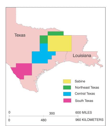 |
Figure 5. Coal assessment study areas in Texas and Louisiana. |
The USGS, in partnership with the Louisiana Office of the Oil Spill Coordinator,
several Federal agencies, and a private aerial mapping company, has completed
about 95 percent coverage of color infrared aerial photography of the State,
as part of the National Aerial Photography Program (NAPP). The NAPP coverages
can be useful in identifying areas that could be affected from potential oil
spills along the Gulf Coast. One of the products from the color infrared aerial
photographs will be 1:12,000-scale digital orthophoto quadrangles that can be
useful as base-maps in geographical information system data bases.
The USGS and DOTD partnership provides current and accurate 1:24,000-scale topographic maps (1 inch on the map represents 2,000 feet on the ground) for Louisiana. The maps depict landscape features such as lakes and streams, highways and railroads, boundaries, and geographic names. Contour lines depict the elevation and shape of terrain. The maps are useful for civil engineering, land-use planning, resource monitoring, hiking, camping, exploring, and fishing expeditions. The map revisions for 1999 are shown in figure 6.
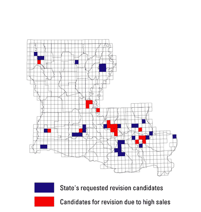 |
Figure 6. Status of 1:24,000-scale topographic map revisions for Louisiana, 1999. |
|
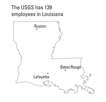
The USGS office locations
|
USGS State Representative USGS Home Page Reports and products |
| AccessibilityFOIAPrivacyPolicies and Notices | |
 |
|