Understanding Earthquake Hazards in Urban Areas
 |
ANSS—Reducing the Devastating Effects of Earthquakes |
| U.S. Geological Survey Fact Sheet 046-03 |
| Version 1.0 |
Earthquake Safety and Economic LossesEarthquakes represent the single largest potential cause of casualties and damage from a natural hazard facing this country. The severity of the impact is a direct function of the performance of structures during strong earthquake shaking. Building codes require that structures be built to protect against loss of life, but they do not generally limit the amount of damage that a structure will incur. Therefore, earthquakes can have large economic impacts. Although damaging earthquakes are infrequent, their consequences can be immense. According to recent studies, a future major earthquake in the urbanized area of northern or southern California could exceed $200 billion in losses, cause several thousand deaths, and significantly impact the national economy. In 2001, the Federal Emergency Management Agency (FEMA) reported that estimated future annualized earthquake losses in |
the United States will average about $4.4 billion/year based on 1990 census figures. FEMA also noted that damages and losses from earthquakes have steadily increased. Population growth, urbanization, and expansion of the built environment all contribute to this trend. In addition, many existing structures are not earthquake resistant and have not been retrofitted to meet current design codes. The effectiveness of emergency response also plays a crucial role in the losses associated with an earthquake.
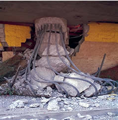
Inflation-adjusted economic losses from magnitude 6.7 or greater earthquakes impacting major U.S. urban centers during the past four decades. The 1995 Kobe, Japan, earthquake is included for comparison, as it also struck an urban area with construction standards similar to those of the United States. (Photo credits clockwise from top right - J. Dewey, USGS; Caltrans, with permission; J.K. Nakata, USGS.)
|
Response organizations, utilities, and transportation agencies depend on rapid shaking-level information from ANSS instruments to guide their critical initial post-earthquake efforts. However, many urban areas do not have adequate instrumentation to provide the input data for these critical maps of earthquake shaking. Decisive action is necessary to counter this trend of increasing losses; improved engineering design and public planning must be part of that action.
1994 M6.9 Northridge, Calif.

|
||
Correspondence between damage and amplified ground shaking in the region surrounding the 1994 Northridge, Calif. earthquake. Circles are locations where aftershock recordings were made, and their relative size shows amplification of ground motion from aftershocks compared to a rock site. Red symbols indicate red-tagged (heavily damaged) buildings. Notice that the damage is highly localized across the San Fernando Valley and is correlated with the ground motion amplification. Damage patterns appear to be related to the type of shallow soils and quality of building construction. If the localized hotspots of high ground motion amplification had been mapped prior to the Northridge earthquake, the most vulnerable structures could have been selectively retrofitted to resist this enhanced ground shaking. However, to recognize these hot spots first requires recording ground motion at many sites in urban areas and across all classes of buildings to assess potential damage. It also requires acquiring records from large earthquakes, not just related aftershocks. |
(2) how buildings respond to this ground motion. Currently neither characteristic is sufficiently well understood. The ground response to seismic shaking can be highly variable and dependent on a number of factors, such as near-surface geology, proximity to active faults, and deeper basin structure. Earthquake damage is often localized where geologic factors combine to amplify ground shaking. Presently recordings of ground motion in urban areas are insufficient to adequately characterize this variability. Not all buildings respond the same to seismic shaking. Response is affected by several factors, including irregular shape, use of different types of structural systems (such as moment frames, shear walls, and base isolation), asymmetrical loading, nonstructural elements, and the coupling between structure and ground. Currently the number of seismic instruments in buildings is insufficient to monitor representative structural types, calibrate design and retrofit standards, and set priorities. Because of these deficiencies in ground and structural monitoring, engineers must infer the characteristics and effects of shaking when they design structures. How Will ANSS Meet the Need for Improved Ground Shaking Observations?Through the Advanced National Seismic System, the USGS will greatly expand the ground- and building-based strong motion recordings in urban areas, thus providing the engineering community with the data they need to improve building codes and structural design practices. The ANSS plan calls for 3,000 additional ground-based instruments and 3,000 structural instruments in 26 seismically active metropolitan areas across the United States. The ANSS ground-based instruments will be positioned to sample a range of different soil types, geologic and basin conditions, and fault proximity. In addition, ANSS instruments will be deployed close to major fault zones to capture large ground motion should faults slip during a major earthquake. Instrument spacing will average 1-2 km across urban basins. Many types of building designs have never been tested by damaging levels of earthquake shaking, and if they have, the level of shaking that produced the damage is not well quantified. ANSS structural sites will be selected so as to validate and calibrate building design and retrofit codes |
||
Use of Strong Motion Measurements in Reducing Future LossesEarthquake-resistant design is the first line of defense in improving structural safety and reducing losses from earth- |
quakes. Structural engineers must take into account two fundamental characteristics of earthquake shaking: (1) how ground shaking propagates through the Earth (especially near the surface), and | ||
|
|||
| and priorities, calibrate post-earthquake evaluation procedures, and advance new methods such as performance-based design standards. Although placement of instruments in every building is not feasible, monitoring representative classes of structures in different areas can produce results applicable to other nearby structures with similar characteristics. Structural instrumentation sites will be coordinated with groundbased recordings so that the input ground motion to the structure can be determined. The data acquired from these ANSS ground and structure recording sites will greatly improve the current design standards for buildings, lifelines, and other structures, and possibly identify critical weaknesses of current structures. In addition, these studies allow for considerable financial savings through prioritization of building retrofits in areas of high ground motion amplification. Seismic Monitoring and Emergency Response Besides facilitating the improvement of building codes, additional seismic | stations are important in
quantifying the
ground shaking for emergency response.
ShakeMap is a tool that depends on strong
ground motion records to automatically
and rapidly generate computer maps that
portray the extent of potentially damaging shaking following an earthquake. ShakeMaps can be used for emergency response, loss estimations, and for public information through emergency response networks, the Internet, and the media. Because ShakeMap interpolates ground motion between seismic stations, and because ground motion can vary widely even over short distances (several kilometers), dense instrumentation is necessary for detailed predictions of damage. ShakeMap is currently running in Los Angeles, San Francisco Bay Area, Seattle, and Salt Lake City. More instrumentation is required to extend ShakeMap to other urban centers, such as Anchorage, Boston, Charleston, Las Vegas, Memphis, New York, Portland, Reno, Saint Louis, and San Diego. Strong motion recordings on and near structures can also be used for rapid |
damage and building state-of-health assessments. User-friendly displays of ground motion recordings are available that provide a facility manager with the information needed to evaluate–whether on-site or remotely–the likelihood of damage to a facility or a portion of a facility. Displays of peak levels of ground motion, combined with color-coded alarm systems and the ability to review recordings from multiple sensors deployed throughout a structure, provide an immediate method to evaluate whether a facility is safe or whether further action is required. In addition, the same data will be relayed to the USGS earthquake information center and integrated into a regional display of ground motion for emergency response and loss estimation purposes. Thus ANSS instrumentation used for monitoring earthquake-generated ground motion and response of the built environment can benefit both local building managers and State and Federal emergency response personnel, while also providing critical data that engineers can use to improve long-term building design codes and methods. |
Contoured displays of peak ground acceleration (PGA) from the February 28, 2001, M 6.8 Nisqually earthquake across the city limits of Seattle. Panel A shows the results provided by ANSS strong motion instruments (triangles) in place at the time of the earthquake. Panel B includes the strong motion recordings from panel A plus data recorded by a temporary array of 23 instruments (+ symbol). Note the identification of an area of strong shaking (orange and red shading) in central Seattle that was not identified based on the ANSS recordings alone. Panel C documents the close correspondence between this region of strong ground shaking as defined in panel B and the area experiencing damage. Red dots represent structural damage and ground deformation (liquefaction, lateral spreading, settling, and landslides). In the future, if instrumentation is sufficiently dense, urban areas of concentrated damage such as this can be identified in minutes following an earthquake and information conveyed to emergency response through ShakeMap.
|
||
The Gilroy Earthquake of May 13, 2002
The Gilroy earthquake of May 13, 2002, provides a vivid illustration of the density of strong motion instrumentation needed to reduce earthquake losses. This magnitude 4.9 earthquake occurred in the southern San Francisco Bay Area near the town of Gilroy. The event ended a post-Loma Prieta earthquake period of relative seismic quiescence in the South San Francisco Bay region that had been ongoing since 1989. Unlike the Loma Prieta event, this earthquake was recorded by dozens of newly installed ANSS instruments designed to detect strong ground shaking from urban earthquakes. The ground motion recorded by this array is shown in view A. The highest ground motion (reds and oranges) is mapped about 10 km east-northeast of the epicenter. The absence of higher ground motion near the epicenter, and the portrayal of localized areas of anomalously high or low ground motion marked by bull’seye contour patterns (e.g., the red high east of the epicenter), are indicative of too few stations in the area. An enlarged picture of recorded ground motion in the vicinity of San Jose, Calif., also includes the recordings from a temporary dense array of instruments (box) that has a station separation of about 1 km (view B). Much more spatial variability in ground motion is clearly evident within this dense array, where an east-westoriented band of higher ground motion is revealed. The presence of this scale of ground motion variability, with an estimated 5-km north-south by 10-km east-west scale, cannot be resolved by the existing ANSS instrument grid owing to insufficient spatial sampling. To resolve similar scale features across the Bay Area requires an ANSS station spacing of 1 or 2 km. Currently the number of ANSS-quality seismic stations in the San Francisco Bay Area is insufficient to map out the variability in ground motion from earthquakes. Approximately 100 ANSS-quality stations exist in the region, spaced every ≈10 km or more. To achieve station spacing of every 2 km will require approximately 600 strong motion sensors across this populated urban area. |
 |
ConclusionANSS offers an important next step in a long-term effort to reduce earthquake losses through improved structural and ground-based earthquake strong motion recordings. The dangers of unsafe underbuilding” and costly “overbuilding” for earthquakes can only be dealt with by the capture of vital information when earthquakes occur. If thorough sets of strong motion recordings are not obtained on engineered structures and in the free-field by the time of the next damaging earthquake, then a great opportunity to mitigate the effects of such natural disasters will be lost. |
|
| AccessibilityFOIAPrivacyPolicies and Notices | |
| |
|