U.S. Geological Survey Fact Sheet 050-03
2003
This Fact Sheet is available in pdf format (2.8 MB)
The U.S. Geological Survey (USGS), in cooperation with local, State, and Federal agencies, operates a network of 50 continuously recording stream-gaging stations in New Hampshire (fig. 1). Accurate and unbiased information provided by these USGS stations on the amount of water in rivers, streams, lakes, and reservoirs in New Hampshire is essential to safeguarding lives and property, monitoring and managing water resources, and understanding the effects of climate and land-use change on hydrology.
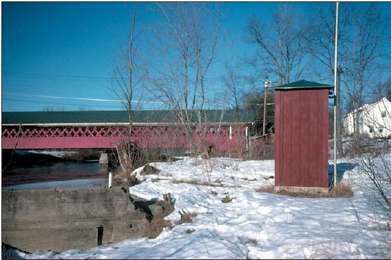 |
| Figure 1. Stream-gaging station at Ashuelot River in West Swanzey, N.H. |
A stream-gaging station is a device (fig. 2) along a river or stream that measures the stage or water-surface elevation of the river. Equipment at the stream-gaging station automatically measures and records the stage every 15 minutes. The stage then is converted to streamflow (defined here as the volume of the water in cubic feet passing the site every second) based on the relation between stage and streamflow. This relation is developed and maintained for accuracy by USGS personnel by measuring the flow of a river directly at each station with a flow meter at various stages throughout the year. Because of ice cover and changes in riverbed form, roughness, and vegetation, the relation between stage and streamflow is changing continually and direct measurements are made frequently.
At some stations--called partial-record stream-gaging stations--continuous streamflow data are not collected, only streamflow information, such as peak- or low-flow data, are collected.
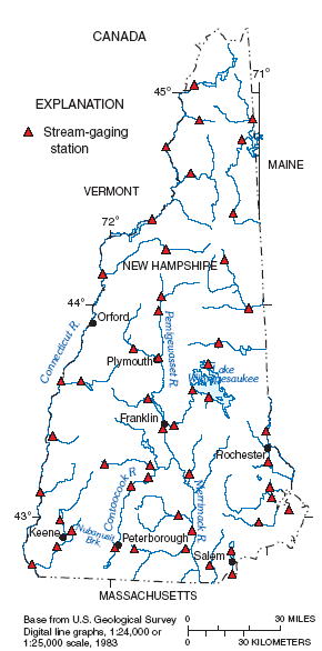 |
| Figure 2. Distribution of active, continuous-recording stream-gaging stations in New Hampshire. |
The earliest known systematic collection of surface-water data in New Hampshire began in 1886 on the Pemigewasset River at Plymouth, by the Proprietors of Locks and Canals at Lowell, Mass. In August of 1900, the USGS began collecting flow data on the Connecticut River at Orford. By 1903, surface-water data collection had begun on the Merrimack River at Franklin Junction, and on the Contoocook River at West Hopkinton. Flooding in 1927, 1936, and 1938, along with interest in the development of reservoirs, led to the expansion of the stream-gaging network to 32 stations by 1939. Through the years, the network has evolved as Federal and State interests in surface-water resources and funds for operating the network have increased.
Currently (2002), the stream-gaging network consists of 50 continuously recording stream-gaging stations (1 is a lake station) and 5 partial-record stations. Stage data from New Hampshire stations are sent by satellite to USGS computers once every 4 hours, and more frequently at times of flooding. Many Federal, State, and local agencies and industries rely on these satellite-transmitted real-time data for disaster response and daily operations. These data are available on the World Wide Web at http://nh.water.usgs.gov and are accessed regularly by many data users. Approximately 13,000 pages of New Hampshire real-time streamflow data are requested through the Web site each month. Historical data from active and discontinued stations also are available on the Web site and daily mean streamflow data are published annually in printed reports.
Stream-gaging stations are distributed across New Hampshire (fig. 1) providing sufficient spatial coverage of the State's waterways. Various stream types are represented by the network"—from steep, mountainous streams to low gradient, meandering streams; from free-flowing streams to streams with sufficient reservoir storage to moderate the effects of flooding; and from small brooks to large rivers. The drainage-basin size upstream from stations varies from 3.6 to 5,493 square miles.
There are some gaps in the basin characteristics represented by the stream-gaging network as shown in figure 3. For example, few sites have a drainage area of 15-35 square miles and most are greater than 35 square miles (fig. 3a). There are few stations with drainage basins in an urban setting (fig. 3b). Mean basin elevation and mean basin stream slope data appear to be adequately represented considering the ranges applicable to New Hampshire (figs. 3c and d). There also are few sites representing mean annual basin precipitation greater than 50 inches (fig. 3e).
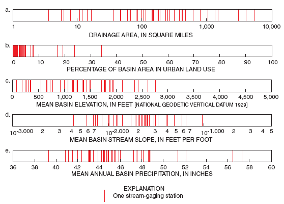 |
| Figure 3. Distribution of stream-gaging station basin characteristics (a) drainage area, in square miles; (b) percentage of basin area in urban land use; (c) mean basin elevation, in feet; (d) mean basin stream slope, in feet per foot; and (e) mean annual basin precipitation, in inches, in New Hampshire. |
The USGS has operated most of the stream-gaging network in New Hampshire, in cooperation with multiple organizations, to ensure uniform costs, consistency of data collection and analysis, quality control, and wide availability of resultant databases. Funding for a stream-gaging station typically is shared between the USGS and a cooperator(s) in proportion to the extent of Federal interests relative to those of the cooperating agencies, and may range from full USGS funding to full funding by the cooperator. In particular, the U.S. Army Corps of Engineers (USACE) and the New Hampshire Department of Environmental Services (NHDES) have been major cooperators in the operation of the network (fig. 4).
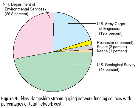 |
In 2002, the annual operating cost of a full-time, continuously recording stream-gaging station with satellite telemetry was $11,300. The entire New Hampshire network cost was approximately $570,000 in 2002, which includes operating the stations, maintaining the data systems, and disseminating the data.
Individual stations in the network have been installed and funded for specific purposes such as flood forecasting and warnings, flood-control operations, operation of lakes and reservoirs, water allocation, monitoring of streamflow withdrawals, and water-quality management, including the maintenance of instream flows. The collection of flow records for more than 10 or 20 years also is necessary to assess water resources, the flow-frequency characteristics of streams, and trends in basin yield.
The streamflow data-collection network in New Hampshire has evolved in response to a diverse range of needs during the past 100 years; therefore, the effectiveness of the network in meeting current and anticipated future data needs must be evaluated. These needs include the protection of lives and property, monitoring and managing water resources, and understanding the effects of climate and land-use change on hydrology.
Flooding is the most costly natural hazards that is experienced in New Hampshire. Streamflow data provide critical information that is used to forecast floods, issue warnings, and operate flood-control structures. The National Weather Service Northeast River Forecast Center (NERFC) is responsible for issuing river forecasts and warnings in New Hampshire. In the Merrimack, Contoocook, and Connecticut River Basins, there are 19 stations (fig. 5) that are used by the NERFC to forecast river flooding.
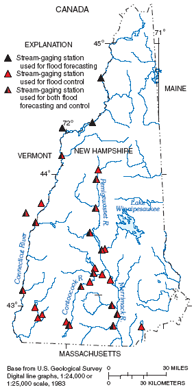 |
| Figure 5. Stream-gaging stations providing data used for flood forecasting and flood control in New Hampshire. |
Real-time streamflow data from 28 stations are used by the USACE Reservoir Regulation Team for managing their reservoirs in the Connecticut, Merrimack, and Contoocook River Basins for flood-control operations (fig. 5). Data from two other stations assist local officials in the Town of Salem, N.H., in mitigating, or lessening the effects of, flooding. The availability of near real-time streamflow data has improved the response time to floods of the NERFC, the USACE, and other agencies.
Historical streamflow data also are used to mitigate flood hazards. Long-term record (greater than 10 years) is required for computing flood-flow characteristics, such as the 100-year flood flow or the flow rate that is exceeded once, on the average, in 100 years. Flow statistics such as these provide the design criteria for building culverts, bridges, dams, and other infrastructure in and near water to ensure that these structures perform safely even during floods. These statistics also are used for floodplain mapping and management and by the Federal Emergency Management Agency to set flood-insurance rates.
Often, flow characteristics are needed at a stream site where no data have been collected. In this situation, statistical techniques that relate flow characteristics at stream-gaging stations to basin characteristics, such as drainage area or channel slope, can be used to estimate the desired flow characteristic at an ungaged site. Accurate flow estimates require a statewide stream-gaging network that spatially covers New Hampshire with an adequate period of record that represents a complete range of basin and streamflow characteristics (fig. 3). Olson (2002) reports that the error in estimating streamflow using statistical techniques would be reduced by adding stations with drainage areas smaller than 45 square miles.
As the population of New Hampshire continues to grow, enhancements to the stream-gaging network will be critical for comprehensive flood forecasting, control, and warning. Basins undergoing extensive development or prone to flooding are potential locations for new stations. In particular, ungaged streams in southern New Hampshire and in areas with recreational development encroaching on streams in mountainous regions are candidates for new stations.
Data from the New Hampshire stream-gaging network are used on a daily basis to monitor and manage water resources. For example, the NHDES funds a large portion of the network to provide information for the management of lakes and reservoirs. Under the Rivers Management and Protection Act, NHDES has the authority and responsibility of protecting designated stream reaches and maintaining streamflows for public uses. To do so requires data from the stream-gaging network.
Streamflow data also are used for drought forecasting and drought management. The streamflow data, along with precipitation data, provide officials at the National Oceanic and Atmospheric Administration and NHDES with the information needed to make decisions regarding issuing drought statements, warnings, and classification levels. The data then are used by the NHDES Drought Management Team to decide on a course of action to mitigate drought conditions. Streamflow data are used for determining the amount of effluent wastewater-treatment facilities can discharge while maintaining stream water-quality standards to ensure public health.
As water resources become more stressed with a growing population, water managers will rely more heavily on data from the New Hampshire stream-gaging network for allocating water resources; monitoring municipal, industrial, agricultural, and recreational stream withdrawals; optimizing hydropower generation; and maintaining riverine habitat. Various network improvements can be considered to support these emerging needs. Stream-gaging stations on ungaged river reaches designated to be protected under the Rivers Management and Protection Act could be established. To evaluate basin yield and water-resource sustainability as demands for water increase, additional stations could be established on ungaged streams in rapidly developing drainage basins. Additional stations on streams flowing into lakes, particularly Lake Winnipesaukee (fig. 1), could improve lake level and streamflow management for multiple users.
The New Hampshire stream-gaging network provides unique data for evaluating the effects of climate and land-use change on water resources. Long-term stations are essential for evaluating trends in streamflow that can be linked to changes in climate, land use, or water use. For example, population growth and sprawl can decrease streamflow because of the increased demands on aquifers that supply some of the flow. Increases in population also may result in increased runoff, and peak-flood flows, and a decrease in ground-water recharge because of the increased amount of developed or impervious land surface. These trends are of particular importance in southern New Hampshire where the population has increased.
To better monitor the effects of changes in land use on hydrology, stations are required in regions undergoing land-use changes such as southern New Hampshire. The collection of data over a long time period also is important because long streamflow records provide more confidence in identifying trends in water resources.
Accurate streamflow data have many uses and are essential to safeguarding lives and property, monitoring and managing water resources, and understanding the effects of climate and land-use change on water resources. To meet the demands of a growing population in New Hampshire, many water-resource issues need to be addressed such as public water-supply sustainability, wastewater treatment, flood forecasting and control, industrial water use, water-quality protection, and riverine habitat. To address these issues, an increase in the statewide coverage to include stream-gaging stations in ungaged basins is important.
Enhancements to the stream-gaging network could include additional stations (1) for flood forecasting and warning in areas where development is encroaching on waterways, such as recreational development along mountainous streams that react quickly to rainfall; (2) on or near ungaged reaches designated as protected under the Rivers Management and Protection Act to assist NHDES in monitoring instream flow requirements; and (3) for lake and reservoir management.
Finally, continued operation of the present stream-gaging network is important. Long-term data and continuity in the network are important for evaluating trends in streamflow. Long-term data also are effective in minimizing the error in computed peak-flood and low-flow frequency characteristics used as criteria for bridge design, flood-insurance rates, and wastewater-treatment-plant discharge permits.
Olson, Scott A., 2003, Effectiveness of the stream-gaging network in providing regional streamflow information: U.S. Geological Survey Water-Resources Investigations Report 03-4041, 64 p., accessed May 28, 2003, at https://pubs.water.usgs.gov/wrir03-4041
Kenneth W. Toppin
U.S. Geological Survey
361 Commerce Way
Pembroke, NH 03275
(603) 226-7808 Phone
E-mail: ktoppin@usgs.gov
OR
Copies of this report can be purchased from:
U.S. Geological Survey
Branch of Information Services
Box 25286 Denver Federal Center
Denver, CO 80225-0286
USGS Fact Sheet 050-03
June 2003
| AccessibilityFOIAPrivacyPolicies and Notices | |
 |
|