[an error occurred while processing this directive]
NATIONAL WATER-QUALITY ASSESSMENT PROGRAM
New England Coastal Basins

MAJOR WATER-QUALITY ISSUES IN THE NEW ENGLAND COASTAL BASINS

The New England Coastal Basins NAWQA study will increase the scientific understanding of surface- and ground-water quality and the factors that influence water quality. The study also will provide the information needed by water-resource managers to implement effective water-quality management actions and evaluate long-term changes in water quality.


man holding fish

Water-quality improvements in the study unit have been significant over the past half century because of advances in the treatment of municipal and industrial wastes. The effects of industrialization and urbanization on the quality of rivers, coastal embayments, and ground-water resources, however, remain as a primary concern to water-resource managers, planners, state and local governments, and citizen groups. Many of these issues relate to nonpoint sources (those sources resulting from runoff events) and are the subject of on-going research and management programs, such as the Merrimack River Initiative, Casco Bay National Estuaries Program, the Narragansett Bay Program, Gulf of Maine Program, and Federal and State anadromous fish restoration. Some of the major water-quality issues that currently face water-resource managers in the New England Coastal Basins are:

WHAT IS THE NATIONAL WATER-QUALITY ASSESSMENT PROGRAM?

During the past 25 years, industry and government made large financial investments that have resulted in better water quality across the Nation; however, many water-quality issues remain. To address the need for consistent and scientifically sound information for managing the Nation's water resources, the U.S. Geological Survey began a full-scale National Water-Quality Assessment (NAWQA) Program in 1991. This program is unique compared to other national water-quality assessment studies in that it integrates the monitoring of the quality of surface and ground waters with the study of aquatic ecosystems. The goals of the NAWQA Program are to (1) describe current water-quality conditions for a large part of the Nation's freshwater streams and aquifers (water-bearing sediments and rocks), (2) describe how water quality is changing over time, and (3) improve our understanding of the primary natural and human factors affecting water quality.


Map
showing NAWQA study units
Assessing the quality of water in every location of the Nation would not be practical; therefore, NAWQA Program studies are conducted within a set of areas called study units. These study units are composed of 59 important river and aquifer systems that represent the diverse geography, water resources, and land and water uses of the Nation. The New England Coastal Basins is one such study unit; it has been designed to (1) include many important New England rivers, (2) represent a mixture of urban and industrial areas, rapidly urbanizing areas, and large forested areas and, (3) include major sole-source aquifers such as the Cape Cod and Plymouth-Carver aquifers. Study activities in the New England Coastal Basins began in 1996.
  • Nutrient enrichment of ground and surface waters and coastal embayments such as the Gulf of Maine, Cape Cod Bay, and Narragansett Bay.
  • Toxic substances in surface and ground waters.
  • Effects of land use and combined sewer overflows (CSOs) on the presence of pathogens in surface waters.
  • Elevated concentrations of trace metals and radionuclides in aquifersand the occurrence of synthetic, organic chemical contamination in ground water.
  • Importance of point and nonpoint sources to pollutant loads in rivers. Effect of dams and impoundments on fish and benthic invertebrate communities. Effects of atmospheric deposition of trace metals, particularly mercury, on lakes, streams, and aquatic biota

STUDY UNIT DESCRIPTION

The New England Coastal Basins study unit encompasses 23,000 square miles (mi2) in western and central Maine, eastern New Hampshire, eastern Massachusetts, most of Rhode Island, and a small part of eastern Connecticut. Important drainage basins include the Kennebec (5,890 mi2), Androscoggin (3,520 mi2), Saco (1,700 mi2), and Merrimack (5,010 mi2) River Basins in Maine, New Hampshire, and northern Massachusetts, and the Charles (321 mi2), Taunton (530 mi2), and Blackstone (335 mi2) River Basins in Massachusetts and Rhode Island. Mean annual streamflow in these rivers ranges from 302 cubic feet per second (ft3/s) in the Charles River at Waltham, Massachusetts to 9,080 ft3/s in the Kennebec River at North Sidney, Maine. Most of these rivers originate in mountainous forested areas and their headwaters are often fast-flowing, cobble and boulder bottom streams. Flow in these rivers is generally regulated by upstream lakes, reservoirs, flood-control dams, and (or) powerplants. The study unit also contains a large number of natural lakes, many of which are enlarged and controlled by dams. The largest are Moosehead Lake in Maine (117 mi2) and Lake Winnipesaukee in New Hampshire (69 mi2). Cape Cod has no major streams yet has more than 350 lakes and ponds.

An estimated 7.8 million people lived in the study unit in 1990. The largest population centers are typically in the southern part of the study unit and include Boston, Worcester, Lowell, and New Bedford, Massachusetts; Providence, Rhode Island; Manchester, New Hampshire; and Portland, Maine. In 1990, land use was an estimated 75 percent forested; 11 percent residential, commercial, and industrial; 6 percent agricultural; 5 percent water bodies, and 3 percent other uses. Major industries include light manufacturing, pulp and paper production, silviculture, hydroelectric-power generation, tourism, and seasonal recreation.

The New England Coastal Basins study unit contains a mixture of rugged mountains, narrow to broad valleys, and flat plains. The entire study unit is within the New England Physiographic Province with the exception of the southern coastal islands of Martha's Vineyard, Nantucket, and Block Island, which are in the Coastal Plain Province. Elevations in the study unit range from sea level along the coast to greater than 6,000 ft in the White Mountains of New Hampshire. Average annual precipitation ranges from 40 to 50 inches, with higher amounts in the mountainous regions; about one-half of this precipitation becomes surface runoff. Average annual air temperatures varies from about 43 degrees Fahrenheit (o F) in the north to about 50o F in the south.

Two principal types of aquifers underlie the study unit: stratified-drift aquifers and fractured- bedrock aquifers. Stratified-drift aquifers are the most productive and are used intensively for public drinking-water supply; several are sole-source aquifers. These aquifers were formed during the retreat of the last glaciers more than 12,000 years ago, as meltwater streams deposited stratified drift composed of sand, gravel, silt, and clay in valleys and broad plains. Bedrock in the study unit ranges in age from Precambrian to Mesozoic and includes primarily fractured crystalline igneous and metamorphic rocks; small areas of Pennsylvanian age sedimentary rocks are found around Narragansett Bay and in southeastern Massachusetts. Wells drilled in the fractured crystalline and sedimentary rocks in the study unit generally yield less ground water than wells completed in the stratified drift, but the bedrock aquifer remains an important source of water for

Picture of The
		  Androscoggin River at Rumford, Maine
The Androscoggin River at Rumford, Maine. Point sources of wastewater have an influence on the water quality of many rivers and streams in the study area. (photo courtesy of Martha
Picture of covered bridge over the Saco River in New Hampshire
The Saco River in New Hampshire. Many of the study units major rivers originate in the White Mountains of New Hampshire and Maine. (photo courtesy of Charles Knox, New Hampshire Department of Environmental Services)
Picture of the Charles river where it drains into the Boston Harbor
The Charles River drains much of the Boston metropolitan area into Boston Harbor. (photo courtesy of Michael Tyo, mtyo@ziplink.net)

some municipalities, industries, and many individual homes not connected to a municipal water-supply system.

The rivers in the New England Coastal Basins study unit have influenced the development of the region's economy. During the past two centuries, the transportation of timber to mills and shipping ports and the generation of power to run the sawmills and industrial mills depended on the rivers and streams. These rivers and streams continue to be used extensively for drinking water, industry, power generation, fishing, swimming, and boating. In 1990, approximately 1,520 million gallons per day (Mgal/d) of water were withdrawn from the rivers and aquifers in the study unit. Both cold- and warm-water fish communities are found throughout the study unit.

blank image blank image

table showing schedule of study activities

Map of the New England Coastal
Basins Study Unit

Map of the New England Coastal Basins Study Unit

SCHEDULE OF STUDY ACTIVITIES

The New England Coastal Basins study is one of several NAWQA studies that began in Federal fiscal year 1997 (October 1996). Study planning and design, and analysis of existing data will be done during the first 2 years, which is consistent in all NAWQA studies. After the 2-year planning period, surface- and ground-water and biological data are collected intensively for 3 years (termed the high-intensity phase). A low-intensity phase follows for 6 years, during which water quality is monitored at a selected number of sites and areas assessed during the high-intensity phase. This combination of high- and low-intensity-monitoring phases allows the NAWQA Program to examine trends in water quality over time. During the planning period, existing data and results from previous studies are reviewed to understand the primary physical, chemical, and biological factors that affect water quality in the study unit and to identify gaps in the current data. Descriptions of how land use and land cover, soils, geology, physiography, climate, and drainage characteristics may influence water quality are to be included in technical and nontechnical reports. Information obtained from reviews of previous studies, along with field checks of existing monitoring stations and candidate sampling sites, and field reconnaissance data, are used to design a sampling program for the study unit.

During the high-intensity phase, new chemical, physical, and biological data are collected for selected areas at local and regional scales to describe the quality of water throughout the study unit. Measurements are made to determine water chemistry in streams and aquifers; the quantity of suspended sediment and the quality of bottom sediments in streams; the variety and number of fish, benthic invertebrates, and algae in streams; and the presence of contaminants in fish tissues. Individual streams and aquifers, chemical constituents, and biological species are selected for sampling to represent the important water resources and water-quality concerns in the study unit and the Nation. A series of technical and nontechnical reports describing results of high- and low-intensity-phase data collection and analysis are planned.

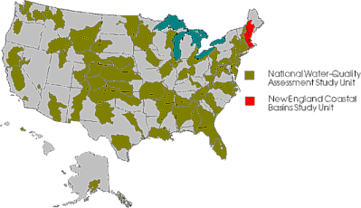
ASSESSING WATER QUALITY IN THE NEW ENGLAND COASTAL BASINS STUDY UNIT

The NAWQA Program is designed to assess the status of and trends in the quality of the Nation's ground- and surface-water resources and to link the status and trends with an understanding of the natural and human factors that affect the quality of water. The design of the Program balances the unique assessment requirements of individual study units with a nationally consistent design and data collection structure that incorporates a multiscale, interdisciplinary approach. Surface- and ground-water studies are done at local (a few square miles to hundreds of square miles) and regional (thousands of square miles) scales to understand the water-quality conditions and issues within a study unit.

An Occurrence and Distribution Assessment is the largest and most important component of the first intensive study phase in each study unit. The goal of the Occurrence and Distribution Assessment is to characterize, in a nationally consistent manner, the broad-scale geographic and seasonal distributions of water-quality conditions in relation to major contaminant sources and background conditions. The following discussion describes the typical surface- and ground-water monitoring components of the Occurrence and Distribution Assessment. The New England Coastal Basins NAWQA study will have a similar design.

SURFACE WATER

The national study design for surface waters focuses on water-quality conditions in streams using three interrelated components--water-column 
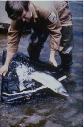
studies, bed-sediment and fish-tissue studies, and ecological studies. Water-column studies monitor physical and chemical characteristics, which include suspended sediment, major ions, nutrients, organic carbon, and dissolved pesticides, and their relation to hydrologic conditions, sources, and transport. Most surface water is monitored at sites termed either basic-fixed sites or intensive-fixed sites, according to the frequency of the sampling. The sampling sites are selected to determine the quality of water in relation to important environmental settings in the study unit. Most NAWQA study units have 8-10 basic-fixed and 2-3 intensive-fixed sites. Basic-fixed sites are sampled monthly and at high-flows for 2 years of the 3-year high-intensity phase. The intensive-fixed sites are monitored more frequently (as often as weekly during key time periods) for at least 1 year, to characterize short-term variations of water quality. Basic-fixed or intensive-fixed sites can be either indicator or integrator sites. Indicator sites represent relatively homogeneous, small basins (less than 100 square miles) associated with specific environmental settings, such as a particular land use that substantially affects water quality in the study unit. Integrator sites are established at downstream points in large (thousands of square miles) relatively heterogeneous drainage basins with complex combinations of land-use settings. Indicator sites are typically located in the drainage basins of integrator sites. Water samples are also collected as part of synoptic (short-term) investigations of specific water-quality conditions or issues during a specific hydrologic period (for example during low streamflow) to provide greater spatial coverage and allow investigators to assess whether the basic-fixed or intensive-fixed sites are representative of streams throughout the study unit. Bed-sediment and fish-tissue studies assess trace elements and hydrophobic organic contaminants at 15-30 sites to determine their occurrence and distribution in the study unit.

Ecological studies evaluate the relations among physical, chemical, and biological characteristics of streams. Aquatic biological communities at the basic- and intensive-fixed sites are surveyed during the 3 years of the high-intensity-sampling phase. These surveys are done along a delineated stream reach and include a habitat assessment of the site and annual surveys of the fish, algal, and benthic invertebrate communities. Additionally, ecological sampling may be integrated with surface water synoptic studies to provide greater spatial coverage and to assess whether the biological communities at basic- and intensive-fixed sites are representative of streams throughout the study unit.

GROUND WATER

The national study design for ground water focuses on water-quality conditions in major aquifers, with emphasis on recently recharged ground water associated with present and recent human activities, by using study-unit surveys, land-use studies, and flowpath studies. Ground-water samples are analyzed for major ions, nutrients, pesticides, volatile organic compounds, and trace elements. Study-unit surveys are used to assess the water quality of the major aquifer systems of each study unit. About 20-30 existing wells are randomly selected to be sampled in each of 2-3 aquifer subunits. Land-use studies focus on recently recharged shallow aquifer systems so that the influences of land-use practices and natural conditions can be assessed. Typically, about 20-30 new observation wells are randomly located within each land use and aquifer type. Results from the 2-4 land-use studies typically performed can be compared with results from the general study-unit survey to determine the effect of particular land uses on ground-water quality. Flow-path studies use transects and groups of clustered, multilevel observation wells to examine specific relations among land-use practices; ground-water flow; and contaminant occurrence, transport, and interactions between ground and surface water.

COMMUNICATION AND COORDINATION

Communication and coordination between the U.S. Geological Survey and other scientific and land- and water-management organizations are critical components of the NAWQA Program. Each study unit maintains a liaison committee consisting of representatives from Federal, State, and local agencies, universities, the private sector, watershed organizations, and those who have water-resource responsibilities and interests. Committee activities include the exchange of information about regional and local water-quality issues, identification of sources of data and information, assistance in the design and scope of study products, and the review of study planning documents and reports. The formation of the liaison committee for the New England Coastal Basins study is planned for 1997.

The overall success of the New England Coastal Basins NAWQA study will depend on the advice, cooperation, and information from many Federal, State, regional, and local agencies, and the public concerned about New England's water resources. The assistance and suggestions of all are welcomed.

SUGGESTIONS FOR FURTHER READING

Gilliom, R.J., Alley, W.M., and Gurtz, M.E.,1995, Design of the National Water-Quality Assessment Program: Occurrence and distribution of water-quality conditions: U.S. Geological Survey Circular 1112, 33 p.

Leahy, P.P., Rosenshein, J.S., and Knopman, D.S., 1990, Implementation plan for the Nation Water-Quality Assessment Program: U. S. Geological Survey Open-File Report 90-174, 10 p.

FOR MORE INFORMATION

Information on technical reports and hydrologic data related to the NAWQA Program can be obtained from:

Keith Robinson, NAWQA Study Chief
U.S. Geological Survey
Water Resources Division
361 Commerce Way
Pembroke, NH 03275-3718
(603) 226-7809
Email:
necb.nawqa@maildnhbow.er.usgs.gov

Internet: NAWQA Home Page

By:Joseph D. Ayotte and Keith W. Robinson Layout by: Glo Morrill and Jim Caras

 
USGS Fact Sheet FS-060-97  
blank gif blank gif


FirstGov button  Take Pride in America button