
Reducing Landslide Hazards in the United States
Landslides threaten lives and property in every State in the Nation.
To reduce the risk from active landslides, the U.S. Geological Survey (USGS)
develops and uses real-time landslide monitoring systems. Monitoring can
detect early indications of rapid, catastrophic movement. Up-to-the-minute
or real-time monitoring provides immediate notification of landslide activity,
potentially saving lives and property. Continuous information from real-time
monitoring also provides a better understanding of landslide behavior,
enabling engineers to create more effective designs for halting landslide
movement. |
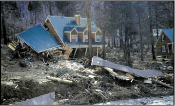
Homes destroyed by a sudden catastrophic landslide in 1997 along U.S.
Highway 50, about 25 miles east of Placerville, California (Photo:
Mark Reid, USGS) |
During heavy rains in January 1997, thousands of tons of earth gave way in the Sierra Nevada, destroying three homes, blocking a major northern California highway (U.S. 50), and briefly damming the adjacent American River. Waters dammed by the landslide quickly flooded two vehicles traveling on the highway, leading to dramatic rescues. Reopening the highway cost $4.5 million, and indirect economic losses from the highway closure exceeded $50 million.
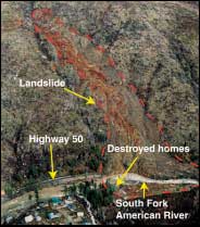 Massive landslide that blocked Highway 50 and temporarily dammed the South Fork of the American River (Photo: Lynn Harrison, Caltrans) |
Several large, active landslides in the same area continue to threaten U.S. Highway 50. Although these slides often move slowly, some have the potential to collapse catastrophically. To help reduce the risk posed by these landslides, the USGS, in cooperation with other agencies, acted quickly to provide continuous real-time monitoring of landslide activity using systems developed by the USGS for monitoring active volcanoes in remote areas. Data from a variety of sensors installed at the landslides are transmitted by radio to USGS computers. Graphs of sensor response are available over the Internet to local officials, geotechnical engineers, and emergency managers.
Many landslides are inactive during dry times and move only during or
following extended periods of infiltration from rain or melting snow. Increased
water pressure in the ground reduces the overall strength of hillsides
and starts downslope movement, but landslide speed and potential destructiveness
can vary widely. Some landslides move slowly, traveling only a few inches
in many days. Other landslides can transform suddenly into mud or debris
flows that travel thousands of feet in a matter of minutes, cause massive
destruction, and kill people. |
Why is it necessary to collect real-time landslide data remotely? The immediate detection of landslide activity provided by real-time systems can be crucial in saving human lives and protecting property.Traditional field observations, even if taken regularly, cannot detect changes at the moment they occur. Moreover, active landslides can be hazardous to work on, and large movements often occur during storms when visibility is poor. The continuous data provided by remote real-time monitoring permits a better understanding of dynamic landslide behavior that, in turn, enables engineers to create more effective designs to prevent or halt landslides.
 Current USGS remote landslide monitoring sites in the western United States (number indicates number of sensors in each area) |
At landslide areas remotely monitored by the USGS, ground movement and groundwater pressures are measured every second. The amount of downslope movement is recorded by extensometers that can detect stretching or shortening of the ground. Ground vibrations caused by slide movement are monitored by geophones buried within the slides. Ground-water conditions within the slides are monitored by porewater- pressure sensors, and on-site rain gauges record precipitation. Under normal conditions, data are transmitted to USGS computers every 10 minutes, but data are transmitted immediately if strong ground vibrations caused by massive landslide movement are detected.
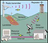 Network for transmission of real-time landslide data |
Currently, five landslides along U.S. Highway 50 are monitored in real-time using 58 instruments. This network, operated in cooperation with the California Department of Transportation, provides engineers and geologists with early notification of landslide activity and with information useful in the design of remedial measures to halt these slides. Real-time data from one of these landslides is available to the public over the Internet at http://landslides.usgs.gov/hwy50.
The USGS operates other remote real-time landslide monitoring sites. Near
Seattle, Washington, a real-time system monitors a slide threatening a major
railway (http://landslides.usgs.gov/woodway), and in Rio Nido, California,
another system monitors a large landslide threatening more than 140 homes.
Remote monitoring by the USGS in Fremont, California, detects landslide movement
threatening downslope homes, and in New Mexico, remote monitoring records the
effects of wildfire in destabilizing hillslopes. In Colorado, remote monitoring
at several landslide sites provides notification of ground movement caused
by large slow landslides or by rapid debris flows.

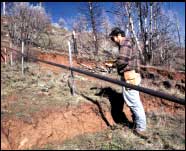
Testing a solar-powered radio telemetry system
for remote transmission of real-time landslide data
(Photo: Mark Reid, USGS) |
Active ground movement, including landsliding, occurs in every state in the Nation. To help reduce the risk from landslide hazards, scientists at the USGS have developed real-time monitoring and other tools that help in understanding and predicting where, when, and how landslides occur. USGS scientists also provide technical assistance to local authorities during landslide disasters. The work of the USGS Landslide Hazards Program is helping to protect people's lives and property from landslide hazards throughout the United States.
 Measuring landslide movement using an extensometer (an instrument that can detect stretching of the ground surface between stable ground and sliding ground) (Photo: Richard LaHusen, USGS) |
Mark E. Reid
Richard G. LaHusen
William L. Ellis
California Department of Transportation
California Division of Mines and Geology
California Office of Emergency Services
City of Fremont, California
Colorado Department of Transportation
Colorado
Geological Survey
Federal Emergency Management Agency
Garfield County, Colorado
National Park Service
Pitkin County, Colorado
Sonoma County, California
U. S. Bureau of Land Management
U. S. Department of Agriculture,
Forest Service
For more information: National Landslide Information Center |
| AccessibilityFOIAPrivacyPolicies and Notices | |
| |
|