![]()
In 1997, water withdrawals from the 155-square-mile Ipswich River Basin in northeastern Massachusetts supplied water to about 330,000 residents, two thirds of whom live outside the basin. Concern over decreased streamflow that results from water withdrawals and the potential effect this has on aquatic habitat, water quality, and recreational use of the river has intensified. Low flows in 1997 prompted the national environmental organization, American Rivers, to designate the Ipswich as one of the 20 most threatened rivers in the United States.The river also is listed under Section 303(d) of the Federal Clean Water Act as noncompliant with the Massachusetts Water Quality Standards.
The Ipswich River Task Force, representing government agencies, environmental groups, water suppliers, and private citizens, formed in 1996 to address problems associated with withdrawals and the river. The Task Force determined that a watershed model would help: (1) determine potential effects of increased human development on water resources and wildlife habitats, (2) make decisions on permitting of existing and new water withdrawals, (3) set streamflow standards to protect biota in the river, (4) determine safe yields of water-supply reservoirs in the basin, and (5) develop a water-resource management plan.
The U.S. Geological Survey (USGS), in cooperation with the Massachusetts Departments of Environmental Management and Environmental Protection, developed a numerical watershed model using the Hydrologic Simulation Program–Fortran (HSPF) to simulate the hydrology and complex water-use patterns in the Ipswich River Basin (fig. 1). The pumping of water from a well that is hydraulically connected to a stream can deplete the flow of the stream, but the effect is delayed, depending on aquifer properties and distance of the well from the stream. Streamflow depletions were computed for each pumped well using STRMDEPL, an analytical program developed for use within the HSPF graphic-user interface (GenScn). Withdrawals were input to the HSPF model, and the model was calibrated to streamflow measured at two USGS gaging stations (South Middleton and Ipswich) for the period 1989-93. The coefficient of model-fit efficiency indicates that at a minimum, the model explained 90 percent of the variance in the observed monthly flow and 79 percent of the variance in the observed daily flow.
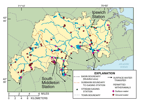 |
| Figure 1. Water withdrawals points in the Ipswich River Basin, Massachusetts. |
The effects of water withdrawals on streamflow were examined for the 1989–93 calibration period by comparing simulations with (1) actual withdrawals, (2) no withdrawals, (3) stopping only ground-water withdrawals, and (4) stopping only surface-water withdrawals. Three long-term simulations (1961–95)—under average monthly 1989–93 withdrawal rates, with no withdrawals under 1991 land-use conditions, and with no withdrawals under undeveloped land-use conditions—were also run to evaluate streamflow over a wider range of climatic conditions and to compute 1-, 7-, and 30-day low-flow frequencies.
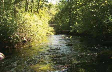 |
| Ipswich River during springtime. |
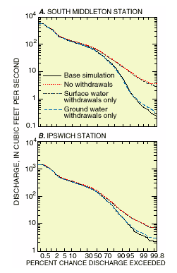
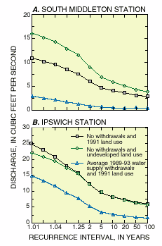
Flow-duration curves developed for the 1989-93 simulations (fig. 2) indicate that, at both gaging stations, simulated flows for the actual withdrawals (base simulation) or with ground-water withdrawals only are about an order of magnitude lower at the 99.8 percent exceedence probability than simulated flows under no withdrawals or with surface-water withdrawals only. The differences between flow-duration curves for various water-use patterns diminish above the median flow. Results of long-term simulations (1961–95) were similar to those for the 1989–93 simulations for similar water-withdrawal patterns. Low flows for simulations under average 1989–93 withdrawals rates were substantially lower than simulated flows under no withdrawals under either land-use condition. For example, at the South Middleton station, the 7-day, 10-year low-flow (7Q10), a widely used regulatory statistic, was 4.1 ft3/s (cubic feet per second) with no withdrawals and 1991 land use, 5.8ft 3/s with no withdrawals and undeveloped land-use conditions, and 0.54 ft3/s with average 1989–93 withdrawals and 1991 land use. The 7Q10 at the Ipswich gage was about 8.3 ft3/s for simulations with no withdrawals for both the 1991 land use and the undeveloped land use conditions, and 2.7 ft3/s for simulations with average 1989–93 withdrawals and 1991 land use (fig. 3).
 |
 |
|
Figure 2. Flow-duration curves for varying conditions of water withdrawals from the Ipswich River at (A) South Middleton, and (B) Ipswich gaging stations, Massachusetts, 1989–93. |
Figure 3. Log-Pearson Type III low-flow recurrence intervals for
the 7-day annual minimum mean streamflow based on long-term simulations
(1961–95) for the Ipswich River at (A) South Middleton, and (B) Ipswich gaging stations, Massachusetts. |
Simulation results indicate that the cumulative withdrawals of ground water in the Ipswich River Basin substantially decrease low flows. Surface-water withdrawals, which are restricted to times of relatively high flow, represent only a small part of the total river flow when these withdrawals are taken. Thus, these withdrawals have little effect on the overall magnitude, duration, and frequency of flow of the river.
The Ipswich River Basin watershed model was conceptualized and calibrated to evaluate the effects of water withdrawals on streamflow. As such, the model can be used to evaluate management plans or to predict flow under conditions that would be difficult or impossible to obtain otherwise. The model is currently being used in a related study of the river to evaluate flows at critical habitat sites under various water-withdrawal conditions. Results of these studies will help water resource planners and managers allocate water for the protection of stream habitat and water quality, recreational use, and water supply.
Zarriello, P.J. and Ries, K.G., III, 2000, A precipitation-runoff model for the analysis of the effects of water withdrawals on streamflow, Ipswich River Basin, Massachusetts, U.S. Geological Survey Water-Resources Investigation Report 00-4029, 99 p.
For more information contact:
U.S. Geological Survey, MA-RI District
10 Bearfoot Road, Suite 6
Northborough, MA 01532
telephone (508) 490-5000
website http://ma.water.usgs.gov
and/or http://water.usgs.gov
Download a PDF version of this fact sheet (1025K)
Download Adobe Acrobat Reader version 4.0 for free