 |
|
|
||||
| Fact Sheet 180–97 |
El Niño and the National Landslide Hazard Outlook for 1997-1998
The U.S. Geological Survey (USGS) has prepared national maps of landslide hazard outlook for 1997 and 1998 by combining forecast information for precipitation from the National Oceanic and Atmospheric Administration (NOAA) with a USGS map showing landslide incidence and susceptibility for the conterminous United States. These predictive maps show contours of precipitation anomalies and zones of landslide susceptibility and incidence for large areas of the country.
The World Wide Web address for the Landslide Hazard Outlook map and additional information on El Niño is: www.usgs.gov/elnino.html.
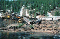
Derailment of California Zephyr
near Granby, Colorado. Landslide triggered by anomalously high precipitation
in the spring of 1985. (Photo: USGS/R.L. Schuster)
Abnormally high precipitation that may accompany the current El Niño climatic event is causing mounting concern that late 1997 and 1998 may be years of exceptional landslide activity. El Niño events are characterized by a warming of equatorial waters in the western Pacific Ocean that spreads eastward to the Western Hemisphere. El Niño events occur every few years, and some events are much larger than others. The El Niño of the winter of 1982-83 was marked by widespread landsliding in different parts of the Western Hemisphere. According to NOAA, the current El Niño may be the largest of this century. Although long-term forecasting is very generalized, a strong possibility exists for increased precipitation with the current El Niño that could lead to increased landsliding.
As part of the USGS response to El Niño, the Landslide Hazards Program is combining the newly digitized USGS National Landslide Overview Map with NOAA's National Climate Outlook Maps. The digital landslide map delineates areas where large numbers of landslides have occurred and areas that are susceptible to landsliding in the conterminous United States. NOAA's National Climate Outlook Maps show contours of probability that El Niño-induced precipitation will be above, near, or below normal for 1997-98. We have not included the below-normal contours in the combined maps, since dry conditions are not conducive to landsliding. The resulting maps of the conterminous United States appear on the World Wide Web and indicate where there may be above-normal precipitation and potential landsliding during late 1997 and 1998.
In the digital National Landslide Overview Map, landslides are characterized as any downward and outward movement of earth materials on a slope. The term landslide includes downward movement of rigid blocks on thin surfaces of slippage and earth and debris flows, where movement is more fluid. Landslide movement can be slow to rapid.
Susceptibility to landsliding is (1) defined as the probable degree of response of geologic formations to natural or artificial cutting, loading of slopes, or to above-normal precipitation and (2) classified as being high, medium, or low. Because individual landslides could not be shown at the small scale of these maps, the percentages used for classifying the incidence of landsliding (number of landslides) are defined according to the percentage of the area observed to have been involved in landslide processes.
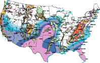

Outlook as of November 13, 1997
How to Interpret Precipitation Outlook:
These precipitation outlook maps show contours of the probability that a given area will experience above-, near-, or below-normal precipitation. These contours are based on measured precipitation from historical El Niño events and several models used by NOAA to characterize climate and weather. These maps do not show areas of below-normal precipitation because this condition does not generally increase landslide activity.
For example, the dark pink contours show areas for which there is a 63 to 67 percent chance for above-normal precipitation; a 33 percent chance for near-normal precipitation, and a 0 to 3 percent chance for below-normal precipitation. In a two-category system, there is approximately an 80 percent chance for above-normal precipitation and approximately a 20 percent chance for below-normal precipitation.
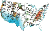

Outlook as of November 13, 1997
How to Interpret Landslide Incidence/Susceptibility:
The landslide incidence/susceptibility map was prepared by (1) classifying geographic areas as having high, medium, or low landslide incidence and (2) evaluating geologic formations or groups of formations in these areas as being of high, medium, or low susceptibility to landsliding.
Landslide incidence is defined by the number of landslides that have occurred in a given geographic area. Susceptibility to landsliding is defined as the probable degree of response of geologic formations to natural or artificial cutting, loading of slopes, or to unusually high precipitation. Generally, it is assumed that unusually high precipitation or changes in existing conditions can initiate landslide movement in areas where rocks and soils have experienced numerous landslides in the past.
The map units are split into three incidence categories according to the percentage of the area that has been involved in landslide processes. High incidence means greater than 15 percent of a given area has been involved in landsliding; medium incidence means that 1.5 to 15 percent of an area has been involved; and low incidence means that less than 1.5 percent of an area has been involved. High, medium, and low susceptibility are delimited by the same percentages used for classifying the incidence of landsliding. Susceptibility is not indicated where it is the same as or lower than incidence.
Abnormally high precipitation that may accompany the current El Niño climatic event is causing mounting concern that late 1997 and 1998 may be years of exceptional landslide activity. El Niño events are characterized by a warming of equatorial waters in the western Pacific Ocean that spreads eastward to the Western Hemisphere. El Niño events occur every few years, and some events are much larger than others. The El Niño of the winter of 1982-83 was marked by widespread landsliding in different parts of the Western Hemisphere. According to NOAA, the current El Niño may be the largest of this century. Although long-term forecasting is very generalized, a strong possibility exists for increased precipitation with the current El Niño that could lead to increased landsliding.
As part of the USGS response to El Niño, the Landslide Hazards Program is combining the newly digitized USGS National Landslide Overview Map with NOAA's National Climate Outlook Maps. The digital landslide map delineates areas where large numbers of landslides have occurred and areas that are susceptible to landsliding in the conterminous United States. NOAA's National Climate Outlook Maps show contours of probability that El Niño-induced precipitation will be above, near, or below normal for 1997-98. We have not included the below-normal contours in the combined maps, since dry conditions are not conducive to landsliding. The resulting maps of the conterminous United States appear on the World Wide Web and indicate where there may be above-normal precipitation and potential landsliding during late 1997 and 1998.
In the digital National Landslide Overview Map, landslides are characterized as any downward and outward movement of earth materials on a slope. The term landslide includes downward movement of rigid blocks on thin surfaces of slippage and earth and debris flows, where movement is more fluid. Landslide movement can be slow to rapid.
Susceptibility to landsliding is (1) defined as the probable degree of response of geologic formations to natural or artificial cutting, loading of slopes, or to above-normal precipitation and (2) classified as being high, medium, or low. Because individual landslides could not be shown at the small scale of these maps, the percentages used for classifying the incidence of landsliding (number of landslides) are defined according to the percentage of the area observed to have been involved in landslide processes.
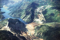
Aerial view of 1983 Thistle,
Utah, landslide associated with high El Niño precipitation, resulting
in $400 million loss. (Photo: USGS/R.L. Schuster)
High incidence means greater than 15 percent of a given area is involved in landsliding; medium incidence means that 1.5 to 15 percent of an area is involved; and low incidence means that less than 1.5 percent of an area is involved. High, medium, and low susceptibility are delimited by the same percentages used for classifying the incidence of landsliding. Susceptibility is not indicated where it is the same as or lower than incidence. The susceptibility categories are largely subjective because the data needed to make precise determinations were not available.
Where more detailed information becomes available, we generally find that the landslide hazard has been underestimated. The level of detail shown for some areas was the result of greater availability of documented landslide hazards. Recent experience with major landslide events in the Western United States confirms that parts of western Washington and Idaho as well as the Sierra Nevada have more extensive landslide hazards than shown on the map.
The NOAA National Climate Outlook Maps used to prepare the national landslide hazard outlook maps are based on (1) precipitation patterns obtained from a composite of past strong El Niño events and (2) results from several forecast models. Data from strong El Niño episodes over the past 102 years were examined in 3-month intervals for above- and below-normal precipitation. In coastal southern California, for example, seven of 11 El Niño years were among the wettest third, three were among the near-normal third, and only one of the eleven was among the driest third. These observations, combined with modern forecast methods, determine the precipitation outlook for the winter of 1997. While the probability of above-normal precipitation is very strong from a climate prediction standpoint (as much as 25 percent above normal in some areas), the probability that precipitation will exceed normal in most of the map area is no greater than about 65 percent.
Because these highly generalized maps for national landslide hazard outlook were prepared at a small scale using limited landslide and climate information, they are not intended for local planning or actual site selection. These maps will indicate broad regions of the United States that may have increased potential for landsliding during the coming El Niño climatic episode. The national landslide hazard outlook maps will be updated frequently during 1997 and 1998 and will appear at the following internet website: http://geohazards.cr.usgs.gov/.
To help prepare for landslides and lessen their impacts, scientists from the USGS Landslide Hazards Program conduct research on landslide processes. An example of this research is the assessment of rainfall thresholds for landslide initiation. These thresholds are used for local and regional landslide warning systems. Additional Landslide Program activities include evaluation of landslide susceptibility at National and regional scales, and emergency response to landslide emergencies and disasters, both in the USA and in cooperation with foreign countries.
Jonathan W. Godt, Lynn M. Highland, and William Z. Savage
![]()
For more information, contact:
U.S. Geological Survey
National Landslide Information Center
Federal Center, Box 25046, MS 966
Denver, CO 80225-0046 USA
Tel: 1-800-654-4966
email: NLIC@usgs.gov
http://geohazards.cr.usgs.gov/
![]()
http://www.cpc.ncep.noaa.gov/products/monitoring_and_data/
| AccessibilityFOIAPrivacyPolicies and Notices | |
| |
|