
Fact Sheet 004-02
Online Version 1.0
Coal Resources of Selected Coal Beds and Zones in the Northern and Central Appalachian Basin
By Leslie Ruppert, Susan Tewalt, and Linda Bragg
The Appalachian Basin is one of the most important coal-producing regions in the world (figs. 1-3, table 1). Bituminous coal has been mined in the basin for the last three centuries, and the cumulative production is estimated at 34.5 billion short tons. Annual production in 1998 was about 452 million short tons (Energy Information Administration, 1999); the basin's production is mostly in the northern (32 percent) and central (63 percent) coal regions. The coal is used primarily within the Eastern United States for electric power generation, but some of it is suitable for metallurgical uses.

|
Figure 1. Locations of the three Appalachian Basin coal regions. Assessments were conducted on selected coal beds and zones in the northern and central coal regions, where 95 percent of Appalachian bituminous coal is produced. The Appalachian Basin is one of five regions being assessed in the U.S.Geological Survey's National Coal Resource Assessment. |
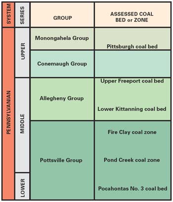
Figure 2. Generalized stratigraphic column showing the relative positions of the five assessed coal beds and zones (plus the Lower Kittanning coal bed) in the northern and central Appalachian Basin coal regions. |
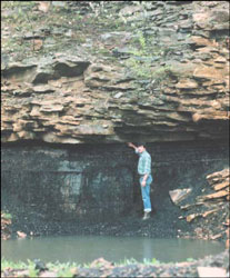
Figure 3. Contact between the Upper Freeport coal bed and the overlying sandstone in Pennsylvania. Photograph courtesy of James Shaulis, Pennsylvania Bureau of Topographic and Geologic Survey. |
|
Table 1. Original (Orig.) and remaining (Remain) coal resources (in millions of short tons) by State in each of five assessed coal beds or zones in the northern and central Appalachian Basin coal regions.
[Resource estimates are rounded to two significant figures. Asterisk (*) indicates that resources are less than reported here because mine maps are not current. Data are from Northern and Central Appalachian Basin Coal Regions Assessment Team, in press] |
||||||||||||||
|
|
||||||||||||||
|
PA |
OH |
MD |
WV |
KY |
VA |
Total |
||||||||
|---|---|---|---|---|---|---|---|---|---|---|---|---|---|---|
|
Coal bed or zone |
Orig. | Remain | Orig. | Remain | Orig. | Remain | Orig. | Remain | Orig. | Remain | Orig. | Remain | Orig. | Remain |
|
|
||||||||||||||
| Pittsburgh | 15,000 | 5,000 | 5,900 | 3,200 | 261 | 0 | 13,000 | 7,800 | -- | -- | -- | -- | 34,000 | 16,000 |
| Upper Freeport | 16,000 | 14,000 | 12,000 | 12,000 | 910 | <810* | 5,000 | 4,500 | -- | -- | -- | -- | 34,000 | <31,000* |
| Fire Clay | -- | -- | -- | -- | -- | -- | 2,100 | 1,800 | 4,200 | 3,200 | 55 | 49 | 6,300 | 5,100 |
| Pond Creek | -- | -- | -- | -- | -- | -- | 5,600 | 5,000 | 4,600 | 3,300 | 570 | 370 | 11,000 | 8,700 |
| Pocahontas No. 3 | -- | -- | -- | -- | -- | -- | 4,300 | 2,600 | -- | -- | 2,900 | 2,500 | 7,200 | 5,100 |
| Total | 31,000 | 19,000 | 18,000 | 15,000 | 1,200 | <810* | 30,000 | 22,000 | 8,800 | 6,500 | 3,500 | 2,900 | 93,000 | <66,000* |
|
|
||||||||||||||
The U.S.Geological Survey (USGS) is completing a National Coal Resource Assessment of five coal-producing regions of the United States, including the Appalachian Basin. TheUSGS, in cooperation with the State geological surveys of Kentucky (KY), Maryland (MD), Ohio (OH), Pennsylvania (PA), Virginia (VA), and West Virginia (WV), has completed a digital coal resource assessment of five of the top-producing coal beds and coal zones in the northern and central Appalachian Basin coal regions (fig. 2). These are the Pittsburgh coal bed, the Upper Freeport coal bed, the Fire Clay and Pond Creek coal zones, and the Pocahontas No. 3 coal bed. Of the 93 billion short tons of original coal in these units, about 66 billion short tons remain (table 1). Results and data are being released inUSGS Professional Paper 1625-C (Northern and Central Appalachian Basin Coal Regions Assessment Team, in press).
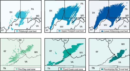
Figure 4. Maps of the northern and central Appalachian Basin coal regions showing the distribution of known coal resources in the Lower Kittanning coal bed and the five assessed coal units: Pittsburgh coal bed, Upper Freeport coal bed, Fire Clay coal zone, Pond Creek coal zone, and Pocahontas No. 3 coal bed. |
Ash yield, sulfur content, calculated sulfur dioxide content, and gross calorific value are summarized in table 2 for the five assessed coal beds and zones and the Lower Kittanning coal bed. For each assessed coal unit, 12 additional chemical parameters (antimony, beryllium, cadmium, chlorine, chromium, cobalt, lead, manganese, nickel, selenium, arsenic, and mercury) were mapped and were included inUSGS Professional Paper 1625-C.
|
Table 2. Arithmetic means of ash yield, sulfur content, calculated sulfur dioxide content, and gross calorific value for the
Lower Kittanning coal bed and the five assessed coal units in the northern and central Appalachian Basin coal regions.
[Data are from USGS Professional Paper 1625-C (Northern and Central Appalachian Basin Coal Regions Assessment Team, in press). wt %, arb = weight percent, as-received whole-coal basis; lbs SO2/million Btu = pounds of sulfur dioxide per million British thermal units] |
||||
|
|
Coal bed or zone |
Ash yield (wt %, arb) |
Sulfur content (wt %, arb) |
SO2 content (lbs SO2/million Btu) |
Gross calorific value (btu/lb) |
|---|---|---|---|---|
|
|
||||
| Pittsburgh | 9.02 | 2.80 | 4.34 | 13,130 |
| Upper Freeport | 12.31 | 2.24 | 3.46 | 12,950 |
| Lower Kittanning | 11.98 | 2.90 | 4.40 | 12,890 |
| Fire Clay | 10.62 | .99 | 1.55 | 12,910 |
| Pond Creek | 7.24 | 1.05 | 1.57 | 13,540 |
| Pocahontas No. 3 | 5.75 | .66 | .91 | 14,490 |
|
|
||||
Sulfur dioxide (SO2) contents were calculated to estimate potential SO2 emissions. Phase II of the Clean Air Act Amendments of 1990 (Public Law 101-549) was implemented in January 2000 and capped powerplant SO2 emissions nationally. This cap limits a plant's emissions to 1.2 pounds of SO2 emitted per million British thermal units (lbs SO2/million Btu). Some calculated SO2 values in table 2 exceed the cap, but the coal can still be utilized if it is blended with low-sulfur coal, washed to remove sulfur, or combusted in powerplants that have installed flue-gas-desulfurization units.
|
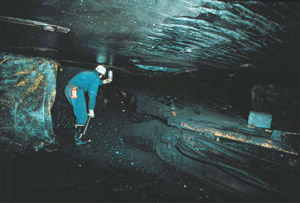
Figure 5. A continuous mining machine in an Upper Freeport coal mine in the Homer City region, Indiana County, PA. Photograph by Ronald Stanton, U.S.Geological Survey. |
Sufficient coal resources remain in the Appalachian Basin to meet regional electrical generation needs. SO2 emission regulations currently favor production of the lower sulfur central Appalachian coals over the more plentiful, but higher sulfur, northern Appalachian coals. Economic pressures may encourage utilities to build new coal-fired powerplants equipped with flue-gas-desulfurization units or to retrofit older units. This scenario could result in increased demand for northern Appalachian coals.
-- Leslie Ruppert, Susan Tewalt, and Linda Bragg
Northern and Central Appalachian Basin Coal Regions Assessment Team, in press, 2000 Resource assessment of selected coal beds and zones in the northern and central Appalachian Basin coal regions: U.S.Geological Survey Professional Paper 1625-C, CD-ROM's.
For more information, please contact:
Leslie F. Ruppert
U.S. Geological Survey
National Center, Mail Stop 956
Reston, VA 20192
Telephone: 703-648-6431
E-mail: lruppert@usgs.gov
URL: https://pubsdata.usgs.gov/pubs/fs/fs004-02/fs004-02.html
For more information, contact Leslie Ruppert
Maintained by Eastern Publications Group
Last modified: 17:47:22 Tue 29 Nov 2016
Privacy statement | General disclaimer | Accessibility